Thursday, 2 October 2014

DALLAS DART


After St. Louis, my next stop on this late-summer 2014 U.S. tour was Dallas (28-30 Sept), which boasts the largest light rail system in the country, so I was curious to find out whether it is also a good one. At least, it's not bad, although it has a few flaws, too.


The light rail extension to Dallas DFW Airport was only opened about a month ago, and ahead of schedule, so I was lucky to use it both on arrival and on departure. While generally it is a great thing to have a train go directly from the city centre to the airport, the location of the airport station is rather inconvenient as it still requires a bus ride in one of these minibuses called TerminalLink to get to the respective terminals except for those who fly with American Airlines (which I hope not to do too often in the future as I was almost victim of their overbooking practices, something long banned in Europe!). So they should really build a second peoplemover on the land side of the airport to distribute departing and arriving passengers with their luggage. Because upon arrival when you collect your bag you're dropped outside the security area and need to find the shuttle bus to the DART rail station, and given the size and layout of DFW this may take some time and you may end up rather dizzy because of all the loops the buses have to run through. Anyway, sad also that there seem no provisions to extend the DART line further into the airport to serve all terminals directly. But, all in all, it is a very cheap way to get to the airport as it only requires a local fare of $2.25. But it also takes 50 minutes from the city centre, and add another 30 minutes to get to your terminal! On the way in, I was also a bit disappointed as it has lots of slow-running sections, notably around North Lake, I guess this is to reduce noise emissions in this affluent area. On the way out, there were not too many air travellers on the train either, although they do a lot of advertising for the new extension. Maybe, DFW is not so much a destination but just a hub?
The DART system is indeed rather large and you can feel its size when you travel on one of the long outer legs. In fact, except for the downtown section it feels more like an S-Bahn, a feeling emphasized by rather long intervals of 20 minutes during off-peak, so taking a picture on these outer sections often brings with it long waits between trains, and with clouds coming and going, it can be frustrating when they reappear just in the moment when your long-awaited train finally arrives and you were hoping to get a good shot.
Probably DART's major flaw is the use of high-floor vehicles with low-floor platforms, so boarding a train often reminded me of our Tatra trams back home in Berlin. In Dallas, however, all trains have been extended with a central low-floor section, so at least it is fully accessible for wheelchair users or people who find it hard to climb the steps. The low-floor section is, however, very short so you tend to avoid it and leave it for the people who need it most. This is the same problem with many European tram system that use old stock with this kind of added low-floor section. In Dallas I usually travelled in the first car, not just for safety reasons, but because seats are orientated in the driving direction and you can get quite a nice view out through the driver's cab. High-floor vehicles generally have the advantage of providing a smoother ride, and generally it is quite good on these Kinkisharyo trains. I never liked their front design, they look too clumsy for urban routes, they should have a somewhat more gentle front, instead they appear like heavy rail trains. Also the bogies should be covered somehow. They also blow a horn at road intersections, and ring a bell when entering a station, but not too excessively, rather according to the crowd waiting on the platform. They generally run 2-car sets, but on the Green Line they used 3-car sets during my stay. I don't know whether this is the norm or just because of the Texas State Fair taking place at the moment so more people travel to Fair Park station. From the platform length, however, I would think that this is the only line able to use 3-car trains, because especially at stations on the older Red and Blue Lines, there are short slightly raised platform sections (like those found on the Hamburg U-Bahn) to match the low-floor entrance, and these would only coincide with the doors of 2-car trains. Newer stations have a platform height that matches the low-floor entrance throughout.


The stations are all pretty substantial structures, with rather wide platforms and roofed sections. As a general feature, all have a sort of vaulted roof, although this may have various shapes. The one most typical for Dallas is certainly the full vault, although this is always divided into 3 or 4 sections, i.e. in between there are always sections without a roof. What makes the stations quite pleasant are the trees planted on most of them. Some sort of artwork can usually be found on the columns that carry the roof or on the wind shields between them. All the stations have ticket-vending machines which were quite easy to handle, and also maps and timetables. The next-train indicators also function well, they display up to four trains, shown in the line's colour but also written out as 'Blue Line' for those not able to clearly distinguish colours. They don't, however, show where the train is going to, which may be confusing for those not good with orientation. The trains are announced accoustically about one minute prior to arrival. Onboard, the trains identify themselves accoustically before junctions, like 'This is the …. (and then there is an artificial break as if they had to look something up) Orange Line – the final stop is Parker Road station'.


In fact, DART has an easy-to-use fare system and it is also rather cheap. While a 2-hour ticket costs $2.25, a day pass is only $5.00. If you travel beyond the DART area, which is already quite a huge area, you can get a 'regional' ticket or pass for $5.00/$10.00, and this includes all of Fort Worth or the A-Train to Denton. The TRE, the commuter railway between Dallas and Fort Worth is also fully integrated, with a 'local' ticket you can use it up to Centreport/DFW station. So, as far as fare integration goes, Dallas is a good place. DART also has a centrally located customer service centre right next to Akard station in their headquarters. The old bearded man behind the window was not too friendly, though, just saying, we've run out of system maps, when a passing lady heard my dispair and said she would bring one if I waited. After a few minutes she came back with a full box of material and filled up the rack. The old bearded man behind the window should have done the same or at least have taken the trouble to organise such a refill, else he shouldn't be working in a customer service centre!

Headways could be better, though, not just for trains but also for buses which often only run hourly. Although with a 15-minute headway on four lines during peak hours, traffic already gets pretty busy on the downtown transit mall. It's also on this section where the trains are rather loud, probably worn out track combined with litter in the grooved rails, while otherwise the ride was fine. The trains are speeding up properly on most outer sections. Many stations are laid out as rail/bus transfers, and interestingly, in Dallas I saw lots of small neighbourhood buses connecting to the trains. These are often indeed needed as, like in many other U.S. cities, stations on outer sections are far apart, too far to my taste. Just travelling through once, I spotted various locations where I thought a station is missing as the train passes through what can be called a dense neighbourhood for American standards, for example between Mockingbird and White Rock or between Lake Highlands and LJB/Skillman (as the latter is on the eastern side of the freeway it is of no use for people living on the western side!) on the Blue Line or a second stop in Las Colinas at the southern side of the town, just like a stop between North Lake College and Irving Convention Center (well looking at the satellite image, there seem to be a provision exactly where I missed it at Green Park Drive). I know there is always the argument of 'more stops mean longer travel times' which is right, but for those people with no direct stops near them despite a line passing by directly, travel times become excessively much longer, and those people have paid the same share towards construction as others in the area. Other stations, like Irving Convention Center, seem to be badly placed, in the middle of nowhere, far from the namesake venue and not accessible at all for residents across the wide road. Why wasn't it placed some 300 m further west on the viaduct across West Las Colinas Blvd? And what about University station? Is this station actually accessible on foot or only by bus?


DART also features one underground station. Cityplace/Uptown station is quite nice, but too deep to be true (and both inclined lifts were out of service on Sunday!). It is a shame in the first place that such a long tunnel was built under a freeway. Why didn't they just use two road lanes to build the light rail line? The other shame is that there is at least one station missing. I read that actually at Knox-Henderson provisions had been made but as all the money had been spent on the superdeep and superlong tunnel, this important area is not accessible by train! If the area next to the southern tunnel portal is hopefully redeveloped one day soon (five years after the Green Line opened the old tracks of the original tunnel approach are still visible!), another stop might be useful in that area, too.


Dallas also has a streetcar system, the McKinney Avenue Trolley or the 'M-Line'. It is a free service, so we shouldn't complain too much, but I thought it is a pity that a timetable can only be found at very selected places, so one never knows when the next streetcar is coming as in fact, one never knows whether it is coming at all. So the least they could do is put up a timetable at every stop and reduce the number of stops, they are ridiculously frequent, but obviously as it is a heritage service they also want to maintain the user-unfriendly part of an old-style streetcar service. I think they should rather include a more modern approach and instead, charge $1.00 or so for a ride. Luckily, the line is currently being extended in the city centre, as so far it had terminated several blocks from the nearest DART station. Interesting to watch the turning loop at the Uptown terminus, a bit like San Francisco but operated electrically.
And as Dallas wants it all, it is now also building a modern, though initially hardly useful tram line. It starts at Union Station, well, to its south rather than in front and clearly visible, and runs on the Houston Street Viaduct to Oak Cliff. The line will be mostly single-track and without overhead wires, but I doubt it will have much success until it is properly extended at both ends. At the Union Station side everything seemed to be in place, there is also a track link to DART as I assume the streetcar will share the DART depot.


I didn't ride TRE, the commuter railway between Dallas and Fort Worth. At Union Station, it seemed quite busy with passengers in the afternoon peak, but again as with all these lines, I think how sad, why don't they convert it into something proper RER/S-Bahn-like with trains running on clear headways every 20 or 30 minutes and electrify the line, in this case, as DART is pretty S-Bahn-like anyway, integrate it into the DART network. Looking at the almost rapid transit-style alignment of the northwestern Green Line branch, with kilometres of elevated sections through/above industrial estates, money can certainly not be the problem. And I would add another downtown station in Dallas in the West End.


I did, however, try the A-Train, this Swiss made regional train which is a sort of extension of the Green Line. It is o.k. for the service it is meant to provide and it was surprisingly busy late morning. What is not satisfactory, however, is the timetable, which sometimes matches quite well with arriving Green Line trains, while at other times there is a 20-minute wait to continue, which is quite a long time considering that the entire journey to Denton is only 30 minutes. Their timetable indicates when the Green Line arrives, but you have to figure out by yourself when this Green Line train leaves downtown Dallas.


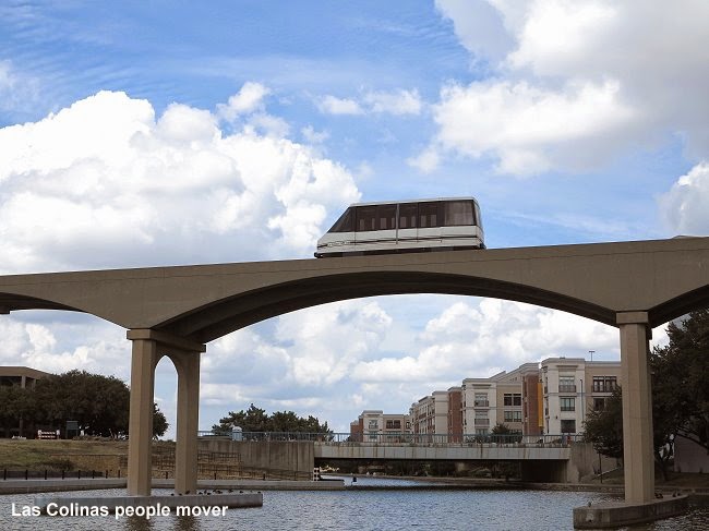
The most bizarre means of transport in the Dallas area is the Las Colinas people mover, once thought to be come a larger distributor in this also bizarre new town. The trains mostly run on demand, but not like the automatic people mover in Morgantown, but manually operated! So at least two drivers are always on stand-by until they receive a call to pick up someone in one of the four stations. Each of the two lines actually operates on its own track back and forth. Two stations are somewhat hidden between or inside office blocks, another is connected to the DART station and the fourth to a parking garage. Taking pictures can be tough if trains pass very irregularly on demand. The last driver who brought me back to the DART station was, however, very nice and waited for a few minutes until I got down on the lawn to take a picture of his cabin coming out of the station again – unfortunately by the time I got there to take my pictures, clouds had again covered the sun... Anyway, thanks for the nice gesture.

Next stop: Houston

LINKS


DART at UrbanRail.Net


Sunday, 28 September 2014

ST. LOUIS MetroLink


The third stop on my 2014 U.S. tour brought me to St. Louis, where I had already been on my very first U.S. trip back in 1995, but at that time I think I only took MetroLink once or twice from the Delmar area into the city and back again.
     The first thing that stroke me yesterday on my first trip from the airport towards downtown was that all stations have a vigilant, which I interpreted as a bad sign after having seen no or hardly any in Chicago or Minneapolis/St. Paul. And as I would find out later, these vigilants are primarily visible on the northern leg, although many of them are young girls who rather play with their mobile devices than actually watch the station. Anyway, not a setting too inviting to take many pictures.
     With a one and a half hour delay to arrive in St. Louis (I think it was due to major problems in the Chicago air space), I did not have much time yesterday to explore the system, so my main day was today, Saturday Sept 27, when trains only run every 20 minutes on each line, so waiting times can be rather long on outer legs. Given that they only operate 2-car sets, the headways should really be reduced especially on the Airport Line which gets pretty crowded up to North Hanley where many people transfer to buses (I resume they are going to northern suburbs like the now world-famous Ferguson).
The second important impression was that this system has a very German feel about it. If you close your eyes and hear the doors shut, with this cracking sound of their folding doors you might think that this is an old train in Frankfurt or Düsseldorf. Also these door-opening buttons were once typical for many German trams. Of course, the high-level platforms give an absolute Stadtbahn feeling, too. In fact, those cars are based on the type B Stadtbahn car developed by Duewag, which was later integrated into Siemens. At the front, next to the driver's cab, they have an additional door like that in Pittsburgh, with steps, but I think it is only used for staff stops at the depots. The cars, however, are a bit aging and don't have modern equipment like station indicators, instead the drivers make all announcements personally, in fact, they almost talk continuously giving all sorts of announcements like next stop and where this train goes, but mostly instructions about what to do and what not. As they do this continuously it gets a bit monotonous and hard to understand.
In the stations there are no properly working indicators, either, not even the automatic announcements are ideal. Even at the junction at Forest Park, the announcement would just say 'A westbound train is arriving in 30 seconds', instead of clearly indicating where this train is actually going. So passengers have to check the front of the train to know if it's theirs. Mostly the driver would then repeat the train's destination so people can jump off if they are on the wrong line. Apparently the network is not properly equipped with a system that identifies trains and thus enables proper information on platform panels. Maybe they wait until they get new trains to modernise this system.

Like on the train front, also at station accesses a huge (M) logo is visible on a pole which also displays the name of the station, so St. Louis boasts one of a few such systems in the U.S. to use a proper logo, something I always welcome
Of all American light rail systems, St. Louis' MetroLink is among the most metro-like when it comes to right-of-way. Long sections are grade-separated, and the newer Blue Line branch to Shrewsbury is almost completely a real metro line. At the existing level crossings, however, drivers are obliged to blow the horn twice, which I find really exaggerated, especially when they can clearly see that the barriers are down and there is no car or person anywhere nearby. For people living nearby any horn not blown would increase the quality of life!


The stations, especially after recently having seen those in Minneapolis/St. Paul, are rather basic, although all have some sort of shelter, but again they are similar to many Stadtbahn stations in Germany, which in most cases are not too sophisticated either. Two of them, Stadium and Forsyth, could also be in Stuttgart, where many such stops are located next to an adjoining tunnel. 


The older underground stations in the city centre are rather dark, with a slightly vaulted concrete ceiling which is illuminated indirectly. The staircases leading to the side platforms on level -1 are quite wide and offset from the platforms. 


The two newer underground stations on the Shrewsbury line are much larger, though not much brighter. What was very disappointing at the University City-Big Bend station (I did not get off at Skinker) were the access stairs and the mezzanine which feel like an unfinished concrete staircase leading down to a cheaply built underground car park, a shame really, because the station hall as such is quite impressive with its massive arches that support the vault.
Accesses seem to be a weak point in other stations, too, most notably at Brentwood where they forgot to build simple stairs in addition to long ramps, or at Forest Park, where only narrow stairs lead to the also narrow platform, although there are two lifts from platform to street level, too. At the airport, the terminus is reasonably close to the check-in area (compared to Chicago O'Hare and Midway and also Minneapolis' both terminals!), but at Terminal 2 passengers have to walk through or over a car park, although the walking distance is not too bad. St. Louis' Gateway railway station is connected to MetroLink's Civic Center station. Interestingly, surface stations in St. Louis also have heating devices – does it get that cold here?
     The Red Line now has a stately length of 61 km! But the question arises if this was really necessary. Apparently, an old railway right-of-way was available for most of its length, but the southeastern most section to College and eventually Shiloh-Scott was built through open countryside. Today was Saturday, so I probably didn't see its real ridership, but I wonder if it gets enough passengers during the week to justify a double-track line through the countryside when many other parts of the proper conurbation don't have any comparable type of service but have to cope with buses instead? Many stations, especially on this branch, are only surrounded by big car parks, whereas trains run through built-up areas without stopping. I would at least suggest an additional station at Belleville South.


A weak point of the otherwise rather fast service is that it avoids large parts of the city centre. I suppose, ideally, the line should have run further north along Washington Avenue or Olive Street to serve important parts of Midtown. Grand station covers parts of that area, but its location under an elevated freeway does certainly not make it an attractive alternative. Hopefully the future Delmar Loop Trolley may one day be extended along this corridor to provide a more local service than MetroLink.
     St. Louis' fare collection system also has a very German feel to it. No fancy smartcards exclusively (there are card readers), instead, day passes are issued as simple paper tickets you show to the bus driver or to ticket inspectors on trains, but I didn't see any. For tickets bought in advance there are German-style validating machines.

Next stop: Dallas

LINKS


MetroLink at UrbanRail.Net


Saturday, 27 September 2014

MINNEAPOLIS/ST. PAUL Light Rail


The Twin Cities were the second stop after Chicago on this year's U.S. tour, and although I didn't precisely like the two cities as such, their light rail system is certainly among the best in the country, especially for its frequency.
The colour-coded lines were built with a 10-year break between them and they are therefore rather different from each other, but they have in common that they link important centres rather than radiating from one city centre and ending in some low-density neighbourhood. The older Blue Line (initially the Hiawatha Line) connects downtown Minneapolis to the airport and the Mall of America, said to be the largest shopping mall in the USA (not sure about that, but with a huge amusement park in the middle it is certainly special). So there is always a certain level of demand for this line which therefore operates every ten minutes throughout the day. The newer Green Line has a similar even ridership, linking downtown Minneapolis to downtown Saint Paul and serving the busy University of Minnesota campus in between. The Green Line therefore also provides a 10-minute headway throughout the day, but additionally it actually runs 24 hours a day, approx. hourly during nighttime hours!


     The two lines, however, have a rather different type of alignment. The Blue Line runs partly segregated with fewer stations, so overall its faster, whereas the Green Line appears to be a typical European-style modern tramway, i.e. it runs on a reservation in the middle of an urban road for most of its length. Its overall speed is slower, but in the end, I guess, it would be my preferred option if I lived along the line, because it is better integrated into the urban structure and stations are placed at major intersections. The trains on this line do have to stop at several road intersections, but all in all, I think they travel at quite a high speed between stations, maybe a surveillance system should be implemented which adapts the speed to the traffic light cycle, and, of course, the tram should at least be able to keep a traffic light on green when it approaches a junction. All in all, the line is well built, the new Siemens trains run smoothly and even the downtown section in St. Paul is run through at a reasonable speed (well, it is not really a busy city centre, most vehicles on the streets are city buses!). 


What does get on my nerves, though, is the continuous bell ringing (also because I could hear it constantly from my hotel room all through the night. Apart from the bell, you can also hear a full horn blow as a special warning, the same sound Amtrak or freight trains all over America produce all the time. How have we Europeans survived without all these warning sounds?


     The major crawling section of the system is in downtown Minneapolis, where also some scissors crossovers look pathetic and feel horrible as the trams rattle over them, notably north of Downtown East (the Metrodome annex has been dropped as this venue is currently being newly built), and between Nicollet Mall and the original terminus at Warehouse District. At Target Field, they have recently opened a new station, and I had been wondering what happened to the old one – well, the trains stop twice, basically the old one is mostly used as it is closer to the Northstar commuter rail entrance and also for exiting the station. So it is not quite obvious why they built the new one with its nice white roof. To skip the old one in case of another tram coming right behind? It's a nice photo motif anyway! The slowest section is actually between Target Field and Warehouse District because of badly coordinated traffic lights. At Nicollet Mall, the proper city centre stop, an additional eastern side platform seems to be under construction. This station has a massive centre structure that carries the roof, but also obstructs the platform enormously. This station may even become busier when the planned streetcar line along Nicollet Mall is implemented.
The junction where the Green Line splits from the Blue Line south of Downtown East isn't too convincing. There are three tracks, and outbound Green Line trains actually have to wind their way through the junction via two adjoining crossovers, so they could theoretically remain on the centre track, which is the inbound Blue Line track, but this way they have to go rather slow and it is not pleasant for passengers who are shaken. In fact, twice the train was stopped at that location, and a prerecorded announcement said, there is a delay to evenly space trains. So were we too fast? Anyway, the train proceeded almost immediately. I would have preferred a proper trailing junction where the outbound Green Line track simply cuts across the inbound Blue Line track.
Both on the Blue and Green Line, all stations are quite substantial structures with some sections covered and with wind shelters – and what I hadn't seen elsewhere, with heaters mounted to the roof which passengers can put on when they freeze. With 27! degrees yesterday on a late September day, I did, of course, not get a chance to test this system, although the first thing that comes to my mind is how much energy does that waste? Can anybody give us their winter experience in Minneapolis/St. Paul?


     Apart from the only elevated station on the Blue Line, at Lake/Midtown, the single most important structure is the underground station at the Airport Terminal 1 – Lindbergh, which boasts a rather pleasant design, not like a tiny underground tram stop, but rather a full metro station. It is however, quite a long way from the actual terminal, so people have to take a short underground people mover, which like in those Las Vegas hotels is referred to as 'tram'. The trains speed up quite impressingly as they go through the tunnel.
     The Blue Line's terminus at Mall of America, however, is really ugly, lying in the middle of a bus loop located on the lower deck of a parking garage. If this is where it ends now, I don't really understand why they made it take a long detour from 28th Avenue, instead of taking it directly into this basement place from the eastern side?


     The spacing of stations wasn't always convincing. In the university area, I would prefer two stops on the East Bank, the first about two blocks further west, and another one, possibly instead of Stadium Village towards the eastern end of Washington Avenue, as the current Stadium Village stop needs time-consuming crossing of roads to get there. In fact, I don't understand why the Green Line needs to take this detour via Stadium Village and an existing transitway to Prospect Park. Why doesn't it stay on a straight alignment from Washington Avenue directly to University Avenue, would save some 2-3 minutes. There was no visible reason for me why trains need to run this detour. In downtown St. Paul, I would have place the 10th Street stop on Cedar Street further down, maybe on 8th, the gap between 'Central' and 10th Street seems to long for a city centre, but again, it is not a very busy city centre anyway.
On both lines, all stations have some sort of artwork, though this is more or less visible at first sight. On the Blue Line, also the roof structure is varying from station to station. There are next-train indicators, but they did not work, they don't even show the destination, just the time and some message. The next train is announced acoustically as for example „The next northbound train to downtown Minneapolis is due in two minutes“. Unfortunately the stations don't display a full system map, which would be good for bus connections, but there is a neighbourhood map also showing bus lines.


     What also gets on my nerves after a while is the endless invitation to report any suspicious activity! What sort of activities do they expect to be reported?
     The original Metro fleet was delivered by Bombardier (they are based on Cologne's low-floor stock) and they are still quite nice, now most also in new livery with a yellow front, although the middle bogie seems to rattle more that on the new Siemens trains, but also these have non-motorised centre bogies which tend to rattle a bit on faster sections. I find both with their livery rather photogenic, and with their colourful front, photos under a cloudy sky even look acceptable. Several units carry full adverts, something I generally don't like much, especially if the advert also inhibits a proper view outside. 


Inside, the trains feature bike racks, which are actually used a lot. But they don't have luggage racks, although the Blue Line goes to a busy airport, there is enough multi-use space, though (so Edinburgh's decision makers should have come here before ordering their trams). During my two days in the area, I only saw 3-car trains on both lines, which combined with the 10-minute headway mentioned above provides a good quality of service. And the trains were reasonably full at all times (I don't know about late night). They have quite a strong air-conditioning unit, certainly good on hot days, and I guess it also operates as heating during freezing winter days. In this context, it is strange that all doors open at all times although there are individual door opening buttons and also sort of detectors like on Bochum's Stadtbahn trains. Yesterday late afternoon, as I was going back to St. Paul, there was some accident and I had to change to bus line 16 instead, and saw once again how much more pleasant it is to ride a train than a bus! By the way, on the trains, corresponding bus routes are announced with their numbers.
     Unlike Chicago's CTA, Metro Transit does have several proper information centres, the one in Minneapolis is located centrally on Marquette Avenue with an old bus front as its shop window. The one in St. Paul, however, is hidden in one of those Skyways that link all the buildings and add to the rather deserted streets.
     Fortunately, Metro Transit has a flat fare system (except Northstar), although with single fares being higher during peak times, but then valid for all sorts of transfers within a 2.5 hour period. Express buses require a higher fare. A 24-hour pass is available at $6.00. They also have a contactless smartcard system called Go-To, but single and day tickets are also sold as paper tickets with a magnetic strip used to check the tickets on buses. The expiry time is printed clearly visible on the ticket.
    What I like about Metro Transit is their overall use of a nice red (T) logo, also used at bus stops (although bus stops could have some more easily visible line information next to the logo post, not just inside the shelters!) The (T) logo is, however, not well established outside the system, for example at the airports the signs just say 'Light Rail Transit'.
     I did not ride Northstar, the commuter rail line, as it is indeed a mere commuter rail system, with some five or six trains in the main commuting direction and only one in the opposite, so to check it out there would only be a single combination possible in the afternoon to return to Minneapolis, which I didn't bother to find out soon enough.

Next Stop: St. Louis

LINKS


Minneapolis/St. Paul at UrbanRail.Net

Thursday, 25 September 2014

CHICAGO 'L'


I have just left Chicago after exploring its 'L' system for five days. I'm sitting on the Empire Builder on my way to Minneapolis/St. Paul, but find it hard to use my netbook as the train wobbles and trembles too much to use a mouse and do some proper work. Anyway, this is September 23rd, and Chicago was the first stop on a 1-month tour through the American Midwest and South, all in preparation for my forthcoming book "Subways &Light Rail in the USA – Vol. 3 Midwest & South" due to be released in December 2014. So there will hopefully be more interesting blog entries in the next few weeks, so check back if you're interested.


The Chicago 'L' is quite well known so I won't give you a general description of the system, just my thoughts and impressions after riding the system intensively over the last few days and taking hundreds of photographs (which is no problem at all, it seems, I have never been addressed by anybody, just yesterday a woman took pictures of me while I was taking photos and probably meant to report me for 'out-of-the-ordinary' activity, although this was actually outside the station proper at Sox/35th on the Red Line). All in all, transit police or other vigilants are hardly present anywhere, which I hope is a good sign. Generally, I would say, people's behaviour is quite good and I felt quite comfortable on all trains. The only sections I didn't ride were the two southern ends of the Green Line beyond Garfield as they go through areas often quoted as delicate.

The fare system has now been completely changed to contactless smartcards, a system called Ventra (would be interesting to know why this is the name as to me it suggests 'belly, womb' as in Spanish 'vientre'). Arriving at O'Hare, it took me quite a while to get my 7-day ticket, not because the vending machines were so difficult to handle, but because they ask for your ZIP code when paying with a card, and I misunderstood this for PIN code, which would be what I would expect to enter. Living in Germany, my credit card can be identified by a 5-digit ZIP code, but what would happen if someone had a British or Canadian card with their weird post codes, or countries with a 4-digit code, would that be accepted by the machine? Anyway, I think that a major entry point like O'Hare really needs a proper staffed ticket window where people are properly helped, although there are staff around to help, there is nothing worse for many people than being confronted with a machine upon arrival to a new city. This brings us already to one of the major deficiencies of the CTA system, a lack of costumer service offices. In fact, there is only one at their headquarters near Clinton (Green/Pink) station. At other stations, there is someone in the booth and they come out when help is needed at the machines, but often they looked like saying 'please don't disturb me'. I think, any transit operator should have several staffed offices in strategic places and well visible where potential riders can go and ask for information. Network maps, especially the large system map, are available at the ticket gates in most stations, the smaller downtown map was also available in some places and also at the Tourist Office.
When you buy a single-ride ticket (with transfer within two hours or so) or a day ticket, you get a disposable paper smartcard, but anything valid longer, is loaded on a proper Ventra plastic card, which costs $5.00, so for a first-time visitor, a 7-day pass costs 28+5 US$. But given that a single ride from O'Hare would also cost $5.00, it's still a good deal. Otherwise a flat fare is required for the entire Chicago area, as far as CTA is concerned, Metra still maintains its own fares and Ventra cannot be used as of yet, I guess it will be expanded to them in the future, too. The Ventra card can also be used to store money to pay in shops. Although a day pass costs $10.00, all in all, the CTA fare system is quite good and easy to handle.


The 'L' system is changing continuously, which is natural, given that some of the elevated sections on the Green or Brown Lines are some 120 years old! CTA has closed entire sections over a longer period for upgrading, and now there were also lots of announcements 'We are being delayed because crews are working on the tracks' and often I actually saw workers walking on the tracks. Good results are perceivable on the southern Red Line, which was upgraded a few years ago, and which allows speeds of 100 km/h, I would guess, providing a similar experience to BART or DC's Metro. The Blue Line to O'Hare is quite fast beyond Belmont, although trains tend to hop a bit, but otherwise it is quite a crawl like most other lines. I also took the Purple Line Express once from Belmont to Howard, but it was so slow I was waiting for the Red Line to overtake (which it didn't, after all). Also many stations have been rebuilt, currently California (Blue Line) is out of service to be rebuilt in its traditional style, while others have been rebuilt at some stage but with a more contemporary design. Most of the Red Line's underground stations have already been refurbished, except Monroe and Clark/Division (the latter being done now), which really improved their appearance. Most of the Blue Line's underground stations, however, still boast their basic and, honestly, rather pathetic appearance, so some action is urgently needed here, too. All in all, the stations are very narrow, and now with lifts having been added to some, space and visibility is even more restricted. One thing I have not quite understood are the continuous underground platforms on both subway routes through the Loop, from Washington to Jackson on the Blue Line and from Lake to Jackson on the Red Line. The areas between the proper stations are lit, though slightly dimmer than the stations, and appear a bit spooky. I didn't walk through them, but what you see from the train is that hardly anyone is there, and those who are, you wouldn't want to meet. So wouldn't it save quite a lot of maintenance costs if these intermediate sections were closed off completely? Why were they built like that in the first place?


Signage generally is good, although next-train indicators do not exist in the entire system. At some stations there are video screens, but like with American TV news programmes, the information they are actually meant to provide, is only visible for a short moment, whereas most of the time adverts are played. If they want to play adverts to pay for the service, a split screen may be a solution, but having to waiting a full cycle until the desired information eventually comes back, is very user-unfriendly. In most cases, I thought that the indicators were positioned in the wrong place, they should be above the platform next to where people wait, actually a kind of norm on all European metros, I think. What I found missing, though, in stations are neighbourhood maps.


The elevated Loop is a funny and fascinating thing, but like a left-over from times gone by. Riding a train on it, is quite pleasant as you can enjoy the view through the streets with their high buildings, though it takes a while for visitors to figure out which line runs around the loop in which direction. But being on the street, it is more like a nuisance, very loud as the trains rattle over the iron structure, and visually rather an eye sore. Many iron trestle structure like old bridges often have an elegant appearance, but the Loop certainly hasn't, also because it looks neglected with paint peeling off. 


I can understand why New Yorkers demolished their elevated lines at least in Manhattan, and why Berlin didn't allow such structures through the city centre in the first place, instead Siemens had to build along a rather tangential route. Many of the elevated stations are not fully accessible, and climbing their steep stairs can be a pain for many, especially for those who travel to Midway Airport on the Orange Line. But, of course, tearing the elevated Loop down nowadays would kill a real landmark, but some modernisation is needed. I also suffered from its noise every night and morning as my hotel was close to the Green/Orange Line viaduct just south of the Loop. Track needs to be optimised and all other measures to be taken to reduce the noise impact. I guess the same is true for most elevated sections which often travel through the backyards of homes, a typical feature of the old 'L' routes.


What I like least in Chicago, however, is the rather unusual naming of stations. In the rest of the world there is a certain understanding that the station name should clearly identify a position within a city and should therefore be unique. In Chicago, however, the same name may appear several times as generally the name of the intersecting street is used, and streets are very long in Chicago. As a result, there are three stations called 'Chicago', five called 'Western' etc. and the worst case, there are two stations called 'Harlem' on the same line, the Blue Line! I wonder whether this system is not just confusing for visitors or also for locals and trip planners? Some stations like 'Clark/Division' actually carry the second part on all signs, whereas on some others, this is added in the acoustic announcements, e.g. at 'Grand/Milwaukee', otherwise I guess you always have to add the line colour to make sure people understand which station you mean. This is certainly easier since line colours were introduced officially in the early 1990s, I wonder how people managed to identify their station before, I guess just like 'Addison on the Howard Line' or so.


Just like in New York, what I miss for such a big system is a proper logo. In some places you can see a CTA logo, but although the 'metro' is generally called the 'L' (CTA always uses these quotation marks), there is no L-logo. True, 'L' is not the nicest letter in the alphabet for a logo, generally symmetrical letters like T, U, S or M are much nicer. Probably a Boston-style (T) would be the best choice, as it is also part of CTA and transit is a word widely used over here. It is also used in several other cities across the country, and I generally prefer a standard logo for an entire country so visitors know immediately what that is when they see such a logo. Elevated stations are, by nature, easily visible, but underground stations certainly need better signage. One example is North/Clybourn on the Red Line, which actually has a nice new headhouse (paid for by Apple, I was told), but you can actually only see it once you are in front of it, whereas a proper logo would be visible (if placed correctly) from all sides.


The CTA trains are all rather uniform although they belong to different generations, but even the blue and red colour on the older cars was removed to make them all look similar in stainless steel only. The new 5000 series is probably a good vehicle and provides a smoother ride than the older types (which are quite good, too), but if I hadn't read about them before, I wouldn't have identified them as new. It is a pity CTA is so conservative when it comes to train design, why don't they dare something more contemporary? So the big novelty for the passengers was the longitudinal seating but I've heard they don't like it much, and neither do I. They do have another, less visible, feature, though: when the doors open, they sort of kneel down to match the height of the platform. Otherwise, their setup is just like that of the older cars. I think the doors should be wider, and the standing area next to the doors should be larger. The driver's seat is always on the right side, although the larger number of stations have island platforms. This means that the driver has to get up and walk to the other side to open the doors, which in some cases costs several seconds (once I observed a driver who was hardly able to walk, no wonder that train had accumulated a long delay and the next was following soon after!). Generally, my impression was that trains run rather irregularly. I was already wondering when I saw the 'timetable' which mostly gives very vague intervals, like every 4-12 minutes...


Another anachronistic feature of the Chicago 'L' are its flat junctions on the Loop, which naturally cause some delays during peak hours, most notably at the northwest corner where two branches come into the Loop and different lines take different directions around the Loop. While the Red and Blue Lines are proper metro lines, the Loop lines have a certain Stadtbahn or light rail feel to them, especially on some outer sections, where the Pink, Brown and Purple Lines have several level crossings despite the use of a third rail power supply, but apparently this is no major safety issue. The Yellow Line (or Skokie Swift as it is still known) also features many level crossings. Until not too long ago, its outer section used an overhead wire inherited from the old North Shore interurban, but now it also has third rail throughout. Fortunately an intermediate station was added on that line recently, but it still runs nonstop through continuously built-up areas. Generally on the entire system, spacing of stations is very uneven. Historically, the old 'L' lines had too many stops, and many were closed over the years, and interestingly, new ones have been added on the Green Line, like Roosevelt or Morgan, and another one is now under construction at McCormick Place, actually in places where previously stations did exist!

Chicago kind of pioneered mass transit in the median of freeways, when it opened the Congress line to Forest Park in 1958 (now Blue Line), which actually replaced an old elevated line. Later new routes were built for the Red Line to 95th/Dan Ryan and the Blue Line to O'Hare. Generally I don't like this kind of alignment as the stations mostly are isolated from the neighbourhoods they serve and mostly not very pleasant to wait in with traffic rushing past on both sides. In the case of the Blue Line's Forest Park branch this is accentuated by very narrow and rather long ramps that lead down to the narrow platform, although the median of the freeway would actually allow a much more generous layout. Things are much more pleasant on the Blue Line's O'Hare branch.
As a network, Chicago's 'L' system basically consists of radial lines, so all transfers are located in the Loop area or nearby. Direct transfer options. i.e. without leaving the closed station area and exit to street level, only exist in very few places, namely Clark/Lake, Roosevelt and Jackson, and of course at Belmont and Fullerton where Red and Brown share the same platforms. In other cases, transfers are made via public streets, now no longer a problem with smartcards programmed for free transfers anyway (there are still many signs saying 'farecard holders only').


There is not much I could say about the Metra commuter rail system as I only used it once. I took the Metra Electric Line to South Chicago and then back to the University of Chicago at 59th Street. I have to say, I didn't like those trains, sitting upstairs you can hardly look out of the window because the windows are so small, and in fact I don't really understand the idea behind those gallery cars. Wouldn't a proper double-decker provide more capacity? Anyway, I don't like double-deckers on urban lines, and this line is pretty urban, even rather like a light rail line from where it splits from the trunk line, running in the median of an urban road, so they should really convert it to something St. Louis-like and run it more frequently to make it worthwhile. A train every hour is really no urban service. As the trunk line has four electrified tracks, a good local service with a train at least every 20 minutes should be possible. The other thought which frequently comes to my mind when I see a line like this is why doesn't it continue further downtown and out north. A tunnel under Chicago River would bring it to a deep-level station at Water Tower Square in the centre of the Magnificent Mile shopping area. Further north it could be linked to one or two of the Metra branches creating a proper RER-style system. If properly integrated into the Ventra fare system it would without doubt be very successful. I always think that Americans should more often look at Australia to see how existing railways can be converted into great urban rail systems.

LINKS


Chicago at UrbanRail.Net


Saturday, 2 August 2014

MÁLAGA Metro


With only very few new metros being built nowadays in Europe (in fact the only one expected in the next few years is Thessaloniki's), I thought I should see the latest on its very first day. Its inauguration had been delayed again and again, and as is quite common in Spain, a final date was not announced until approximately two weeks ago. July had been targeted some months ago, so I think that eventually they chose almost the last day of this month to keep the promise and at the same time have the maximum time to adjust and prepare things.
Well, eventually, after an official inauguration in the morning, doors opened for the general public at around 1 pm on 30 July 2014. Being in the middle of the week and during holiday season, the new metro was able to cope with the crowds, which had accumulated especially at El Perchel, the city-side terminus next to the city's main railway station. Travelling on the metro was free on the first day, but everybody needed a smartcard, which was distributed for free, to open the fare gates.
For a first day, service was quite regular and during the four hours of exploring each and every station, I did not observe any major disruptions or delays. There was a lot of staff around to help people, lots of them probably students on a summer job, while from autumn they will be among those who actually profit most of the new system. All in all, the opening was well prepared, although no spectacular party was held. I think the general reaction from the locals was quite positive, too.
The following day, the first day of normal service with everybody requiring a proper ticket, most stations seemed calm, some had more staff than passengers, although slowly, more and more people came to explore the new lines. At the end of the lines, many stayed on the train, especially on L1, as this line terminates in the middle of nowhere and with the heat outside, people were more comfortable staying on a well air-conditioned train. On that day, however, I observed that some of the next-train indicators did not display anything but a standard welcome message saying that trains would pass every 7.5 minutes and 'Gracias por su confianza' which sounds a bit like 'please, trust us!'.

So, let's have a closer look at stations and service. The first thing that surprised me quite positively when I entered El Perchel station for the first time was the fact that it is a bi-level station, when I had expected a simple station where the two lines converge. But this station was generously laid out for cross-platform interchange between L1 and L2, with a complex junction to the west of that station. If I observed it correctly, in the future people can change here in the opposite direction on the same level. As for now, trains actually switch from one line to the other, so on each level, one track is currently not used:


I assume that the bi-level tunnel than continues to Guadalmedina, from where line L2 is planned to continue north, come to the surface and serve 4-5 stops on its way to Hospital Civil. By 2017, however, line L1 is supposed to continue from Guadalmedina to Atarazanes and thus finally serve the city centre proper. This leads us to one of the major problems of the new system: it terminates short of what most people would consider the city centre and the busy old town. El Perchel is located conveniently between the railway station and the bus station. It is the only station with exits at both ends of the station, although from the platform level up to the large mezzanine, stairs and escalators are only available at the eastern end of the station. A third exit next to the railway station shopping mall is still under construction. I don't consider the name of the station very helpful, although it is consistent with other station names, i.e. they mostly refer to the neighbourhood where the station is located. But for El Perchel, something like 'Estación Intermodal' as initially shown on project maps would be more useful. There is an acoustic announcement that transfer to all sorts of trains and buses is available here, though, but station signs do not include a secondary name such as 'El Perchel – Estación Renfe' or so (generally I don't like ADIF's latest fashion to call railway station after some local hero, either, as it makes names very long and difficult to display in full length, resulting in something like 'MLG. M. ZAMB'...).


The first station on L1, La Unión, is the only one different from the otherwise standard pattern. This is due to the fact that it lies below a narrow street and therefore has two platforms one on top of the other (inbound on the lower level). The upper level extends into a side street and accommodates the ticket barriers. This narrow street is also the cause for two rather tight curves, the one to the west on the way to Barbarela being extremely tight so trains slow down to 10-15 km/h and you can hear the wheels squeaking. The tracks on the rest of the line are pretty well laid with proper super-elevation in curves, so maximum speeds of 70 km/h can be reached on longer stretches between stations, like between Portada Alta and Ciudad de la Justicia on L1 and between Puerta Blanca and Palacio de los Deportes on L2.
From Barbarela to Ciudad de la Justicia as well as all stations on L2 are mostly identical. They all have one (and some also two) encased entrance pavilion, but I only saw a free-standing logo pole at Palacio de los Deportes. There are up and down escalators as well as stairs between them leading to a large vestibule where the ticket vending machines and fare gates are located. All of them also have a staff office, but I wonder whether this will be manned during normal service. Also a lift connects the surface to the mezzanine. Compared to those in Bilbao, the fare gates are somewhat slow to react and open, which caused some overcrowding on the first day at El Perchel, especially as tickets have to be checked also on the way out (mostly due to the fact that there are five surface stops without fare gates). They also stay open for a while, so it will be easy to follow someone without paying.


Once beyond the fare gates, again a doube set of escalators, stairs between them as well as a lift connect the mezzanine to the island platform. The platform level features a high ceiling, in fact no ceiling at all, instead the space on mezzanine level is open and unused, although massive concrete girders kind of separate the proper platform level from that open space above, so maybe in the future it would be possible to add a proper ceiling and use the space above. The uniform design of stations is, of course, boring but functional and pleasant. The walls behind the tracks are just grey, and hopefully some colourful art is placed there in the future to give the stations some extra touch. In the original proposals shown some 10 years ago, all stations had bright colours, each a different one. But in the end, the Andalusian government, just like in Sevilla, opted for this rather inconspicuous design, giving priority to functionality rather than artistic design. The platforms are very wide and include all state-of-the art information panels, next-train indicators, area maps, network maps, etc. The length of the platform is laid out for double trainsets, but for the moment only single units will be used. Although I love these wide spaces, from an economic point of view, they are a waste of money, considering that such a huge space is continuously ventilated and that 4-6 escalators plus 2 lifts in each station consume a lot of energy. Some stations could certainly have been built without a proper mezzanine, given that platforms are wide enough and exits located at the ends anyway, to place fare gates on platform level. On the other hand, I was missing some additional exits from the large mezzanine, like at Princesa (which on some maps and displays has an additional 'Huelín' in its name), there should certainly be a second entrance on the south side of the road junction to avoid long detours.


Although the joint operation of L1 and L2 is a good thing, it has caused a lot of confusion among the new passengers, especially as fixed direction signs show 'El Perchel' for inbound trains, but the electronic displays indicate the real destination of the train, i.e. 'Andalucía Tech' or 'Palacio de los Deportes'. They should change the signs to 'El Perchel – Andalucía Tech' or so, because once the line is extended to Guadalmedina, they will need to change the signs anyway. Also, on the trains, before arriving at El Perchel, there should be an announcement that this train continues on the other line. Talking about acoustic announcements, the next station is announced in Spanish and then also in English. The English announcement seems to be a bit louder than the Spanish, and with the female speaker not just saying (or shouting) 'next station', she also announces the name, which due to her slight foreign accent caused at least some smiles on some passenger faces.


On L1, trains reach the surface at Universidad from where they continue west serving another four surface stops which are basically what you would expect of any modern European tram system. The track is not covered by lawn, however, but embedded in cobblestones. The noise on this stretch is quite low, though. There are several level crossings on this section, and I wonder whether the traffic lights work properly or not, but these first days they had extra posts at many of them making sure no cars cross when a tram approaches. Many areas along this surface section are rather undeveloped or stuck in some development due to the economic crisis. The area houses many university facilities, so this section of the line will get busy when the new term starts. The depot and control centre are located at some distance from the last stop Andalucía Tech. The surface stops have a reasonably wide roof, so it provides some shade in the hot Andalusian sun, also the open space with stone benches causes some air ventilation. Wisely, stops in the inbound direction have more sitting space than outbound. On the second day, extra staff was instructing people to validate their tickets as there is no clear sign and not doing so would cause problems at the exit gates in the underground stations.


The metro trains are actually standard low-floor tram vehicles, the modular Urbos 3 built by CAF and also in service in other cities like Sevilla and Zaragoza. I think they have a quite pleasant design and at 2.65 m, they feel rather spacious. The ride is pretty comfortable, despite the hard green seats (which for my taste have backrests at an appropriate angle!). What is most amazing on such a type of transport system, which after all has the appearance of an underground tram system, is that the trains run in ATO mode in tunnels, i.e. speeds are controlled automatically and the driver just presses a button to start the train after a station stop, just like a proper modern metro does. Sevilla's metro, which is completely segregated and even has platform screen doors in all stations, uses the same type of ATO, I assume. In Málaga, station drafts from as late as 2010 still showed platform screen doors, too, but these were then omitted. Other metros like that in Madrid show that these are not really necessary. As a result of the ATO system, doors are released somewhat too slowly, and people keep pressing the button trying to open the doors before the green light appears. Generally, in all the stations, except La Unión, the train stops in the half closer to the exit, which is very wise. Actually, the second half of the station could at least be closed off with a ribbon to avoid that people wait too far away from the train. Fortunately, stations were made long enough to allow 2-car sets if demand grows or for special events at the Palacio de los Deportes. That station does have a much larger entrance pavilion, but actually no exit in the direction of the arena, so passengers need to walk around that entrance building to get into the metro. In fact, I think there should actually be a full exit at the western end of the platform, at least during events at that venue. At La Unión, the station with the respective platforms on two different levels, and with the stairs located in the middle, the trains stop at the front end of the platform, which should be marked on the floor or on the walls.


As for fares, Málaga is a bit like Sevilla or Bilbao, no real integration with bus services, but at least partly shared stored-value tickets. The Consorcio de Transportes, the local transport agency, already had such a card, and this can also be used and loaded on the metro. For one ride 0.82 EUR is deducted. I do not see the point why Metro de Málaga has issued and distributed its own smartcard, which is only valid on the metro. Using their own card, a trip costs likewise 0.82 EUR. Using the Consorcio card, a discount is granted when changing to other modes. Single trips for the occasional metro rider cost 1.35 EUR.

As the opening date of the metro was announced at rather short notice, there was no time to adjust bus lines, although I wonder if this is intended, as the buses are operated by a different company. The L2 corridor is actually served by numerous buses, all of which go directly into the city centre, so many people will continue to use the bus instead of the metro. I suggest that Metro establishes a continuous free bus shuttle between El Perchel and Alameda as long as the metro extension is not completed. The cost of such a service would easily be compensated by more paying metro riders.

In the initial project, the metro was to be extended further east to Malagueta, and with an intermediate station slightly further east than the one now planned as a terminus at Atarazanes (a name referring to the nearby market), although the station will actually lie beneath the northern lanes of the Alameda, where most of the city's bus lines end/start or pass through. Before the current project was decided upon, there was also a proposal for a surface route along the Alameda, a wide tree-lined avenue. I would have considered that a feasible option, a ramp on the western side of the Guadalmedina river would easily be possible, with the road there being much too wide anyway. Along the Alameda, the tram would have become a visible part of the urban transport scene, and for the price of digging a tunnel below the river, the tram could have reached beyond the initial Malagueta terminus. Anyway, whatever the decision is, I think that Málaga has chosen the right type of system, which combines metro with tram and thus allows future extensions on the surface through outer areas.

So with this system now finally in operation, let's hope that Granada is also able to enjoy its 'Metropolitano' soon, although there the underground portion will just be a short section of the entire line.


Besides the new metro, Málaga also boasts a rather busy Cercanías line that connects the city with coastal towns such as Torremolinos and Fuengirola. The airport is located between Málaga and Torremolinos and is also served by an underground station every 20 minutes. The new station there was built a couple of years ago when the airport was expanded and a longer section of the railway line was put underground; this section features another underground station called Guadalhorce in an industrial area and thus barely used. Another section closer to the city centre was put underground in conjunction with the construction of the high-speed line into Málaga and features an underground station at Victoria Kent. Slightly older are the underground stations adjacent to the main railway station, now called María Zambrano, from where a single-track extension leads further into the city centre, with a rather narrow single-track stub-end terminus at Málaga Centro-Alameda. The station actually lies on the western side of the riverbed, but one of the access tunnels runs below the river to an exit quite close to the western end of the Alameda. So, as of now, the Cercanías line thus actually gets closer to the old town than the metro. Trains run every 20 minutes to Fuengirola, the headway being limited by the single-track stub and also other single-track sections beyond the airport. At Torremolinos and Fuengirola, trains also stop underground. There was a project to extend it further west beyond Marbella and regauge it to 1435 mm so that long-distance trains can serve the Costa del Sol directly from Madrid. But given the current economic situation and with many other rail projects unfinished, this project does not seem to be a priority. A second Cercanías line, C-2, is operated between Málaga and Álora on the old Iberian-gauge track towards Córdoba, but with less frequent trains than on line C-1.


LINKS


Málaga Metro at UrbanRail.Net