This was my first visit to Oslo after
almost 10 years. I had come in autumn 2003 in preparation for my book
'Metros in Scandinavia' (still available!), so I focussed mostly on
the T-bane system, although I did a bit of tram riding, too. This
time (23-28 July 2013) I had a closer look at the tram system as the
visit was in preparation for my forthcoming 'Tram Atlas Northern
Europe'.
All in all, Oslo has quite an extensive
urban rail network considering the size of the city (around 630,000
inh.) and its metropolitan area (about 1 million). There is a dense
tram network that primarily serves the central area, a metro (T-bane)
that primarily links the suburbs to the city centre, plus a frequent
Lokaltog (suburban & regional rail) network for the larger urban
area and region.

T-bane
The most striking difference I noticed
since I was here last is the completely renewed rolling stock on the
T-bane. Back in 2003, all trains were still red, some older than
others, and in the meantime, all have been replaced by new Siemens
3000-series 3-car sets. These are similar to the V train on the
Vienna U-Bahn, wider, of course, as Oslo's T-bane trains are among
the widest in the world at 3.2 m, allowing 3+2 seating in one row.
Instead of red, the new trains were painted white with grey doors,
but I guess that this was not a very good decision, as the white
colour after a few years looks rather dirty, which becomes especially
apparent when one of the older 3-car sets is coupled to a brand new
one that still looks beautifully white. In any case, I would have
preferred a red livery, much more noticable as a company brand,
whereas the white trains look pale in the landscape, and I realised
on the first day, which was covered with white clouds, that there is
no contrast between train and sky. I would have to come back in the
dark winter to see if the white trains look shiny then. Otherwise
they are prefect, smooth ride, nice spacious interior, quiet, but
probably too expensive for 'normal' cities (due to steep gradients
they need more motorised axles and advanced brakes as well, I
suppose) and that's why Siemens has recently come up with the trashy
Inspiro metro train instead of developing this train to be used as
their standard metro train.

The T-bane often reminds me of the
Frankfurt U-Bahn. With rather long trains it carries large crowds,
but despite the metro-like sections it does not really appear to be a
proper metro. Except for line 1, all other sections are now
grade-separated and operated with a third-rail power supply, but the
route alignments, often very winding and steep) and especially the
standard of the surface stations make it look rather like a typical
German Stadtbahn: most surface stations are just an asphalted
high-level platform with little more than a small shelter (again, I
have never been here in the winter, but I guess people know their
timetables well to avoid extra waiting in the cold...). Some have
recently been upgraded along with a line upgrade (like currently on
the eastern leg to Bergkrystallen or the entire Grorudbanen to
Vestli), but the upgraded stops now appear to be modernised surface
Stadtbahn stops in Frankfurt. The only exception is Ensjø, which has
only recently received a more substantial upgrade and is now partly
covered (awaiting construction on top of it), but as in many other
cases, access to the station from the western side is still via a
public bridge, i.e. if you want to get to the opposite side, you
cannot get from one platform to the other inside the station, but
need to take a detour (in other cases often quite long and badly
signed) via a bridge that does not belong to the station complex.
Some of the newer surface stations like Sinsen and Bekkestua at least
have an overall roof structure with wooden elements, but cold winters
may also have suggested fully encased stations here (like Kalasatama
in Helsinki). Some of the underground stations, though pretty
metro-style in layout, are not too pleasant, my negative favourite is
Trosterud, which I renamed Trostloserud (trostlos in German is
desolate). Luckily Carl-Berners-plass has been refurbished a bit with
coloured glass panels, but the overall inpression is still that of a
damp cavern, and a ceiling other than black would brighten the entire
space up enormously (the same is true for Nationaltheatret). My
favourite station remains Stortinget with its large and clearly laid
out central vaukted hall, the wide ramps down to the platforms and an
easily distinguishable colour scheme. Even the rather new and elegant
Nydalen station appears very badly lit.

Line 1 up to Holmenkollen and
Frognerseteren is a different case altogether. As a local expert told
me, decisions in Oslo are not always predictable and rather
spontaneous and this is probably how the Holmenkollbanen also became
a 'metro' line with third-rail power supply. Ten years ago, it used
to be mostly operated by the unpopular 2000-series, but now it is
also operated by the Siemens 3000-cars, unsuitable for this line in
many respects. First of all, the platforms, though somehow upgraded a
few years ago, are too short for the 3-car trains, so only the doors
in the first two cars can open. In a very user-unfriendly way, this
policy is also maintained at Holmenkollen station, where the
platforms were built for 6-car trains! and where most passengers
(tourists that go to the ski jump) get off, completely confused by
the fact that the doors don't open in the third car (though announced
also in English several times on the route), but there can't be a
technical or logical reason why the driver shouldn't open all doors
at this station. Precaution, in case he/she forgets to switch it back
to selective opening for the following stops? I would think that in a
high-tech country like Norway this should actually be done
automatically by the operation control system.
In any case, I think that the Siemens
trains, good as they are on proper metro lines, are not the ideal
choice for this route. They virtually torture themselves up the
winding route at the lowest imaginable speed, both up and down, and
leaving quite a wide gap at many platforms, as normal metro cars are
simply too long for such a winding route. Ten years ago, there was
some discussion whether the Holmenkollen line should rather get
connected to the tram system. Technically, I guess it would have been
wiser to use some sort of articulated light rail cars like the Alstom
RegioCitadis. From a passenger's point-of-view it is certainly better
to have it connected to the metro tunnel, but as only 3-car trains
can be used, while on all other lines 6-car trains are the standard
during most of the day, line 1 doesn't fit properly into the shared
(overloaded) tunnel headway (and therefore for some time they were
actually curtailed at Majorstuen, but passengers claimed a through
connection into the city). Whichever route would be chosen to bring
it into the city centre as a light rail line on existing or new tram
tracks, this would certainly increase travel times. On the other
hand, I found it quite a luxury that all line 1 trains go to the
Frognerseteren terminus, which is only useful for walks through the
woods, and trains were close to empty even on the best days of summer
beyond Holmenkollen. The last houses are at Lillevann, but even that
stop seems to be barely used during daytime, so terminating every
other train at Holmenkollen (and opening all doors there) would just
be as fine. It is not quite clear either why a third rail power
supply was necessary on this line after more than a 100 years of
overhead wires. The route still has many level crossings, where
generally an overhead equipment seems safer, but I guess that
maintenance is easier, especially in harsh winters, with a third
rail. All level crossings are protected by automatic barriers.
Otherwise, the formerly used switching from overhead to third rail,
as has also been done in Rotterdam for many decades now, could have
persisted in Oslo, too. I assume that the visual impact of the
overhead equipment was not an issue here, as it is in many new tram
cities, as the overhead lines had been on this line longer than most
houses alongside it.
The junction where all western lines
converge near Majorstuen station reminded me a bit of some 100-year
old junctions on the London Underground. All branches diverge in a
grade-separated junction, but especially outbound L2/5 trains crawl
over the L1/6 tracks. Inbound trains often have to line up before
getting into the busy tunnel. There are plans for a second city
tunnel plus a new line to Fornebu (old airport area), and this would
require a complete reconstruction of Majorstuen station into an
underground transfer station, requiring new approaching tracks, but
this could be another 20-30 years before it is built.

In general I was amazed that the T-bane
runs its normal timetable also during the summer holidays, while the
tram service (much busier on some routes like line 12 with tourists)
was reduced from a normal 10-minute to a 15-minute headway. Most
T-bane trains ran with 6 cars, when a 3-car set would have been more
than enough.
What has also improved over the last
years is the Ruter fare system. Previously those stations located in
the municipality of Baerum, west of Oslo, were outside the Oslo zone
and an extra fare was required. Now all T-bane stations and tram
stops are within zone 1 (Oslo), so a 24-hour ticket for 80 NOK (some
10 EUR) or a 7-day pass for 220 NOK is enough to explore the urban
rail system. And unlike other Norwegian cities, these passes are also
good on the NSB suburban rail network (not on the airport train
Flytoget – but you can get to the airport also easily on an NSB
train! > 4 zones). Now mostly electronic tickets are used, a
Reisekort for regular passengers, but available without an extra
charge also when you buy a 7-day ticket, or an Impulskort for single
tickets or 24-hour-tickets bought from vending machines or kiosks.
Oslo, however, does not really take full advantage of these
electronic tickets, as they just need to be validated once just like
paper tickets used to. So, there is no exact statistics how many
passengers are carried by which operator, in many other cities the
primary reason to introduce such a system in order to distribute the
revenue accordingly. Metro stations in the central area have proper
ticket gates, but these were not in use (maybe they are at certain
peak hours – but this would require at least one manned access as
there are still some paper tickets left). The only ticket inspectors
I saw in five days were at the ferry terminal on a nice sunny day...
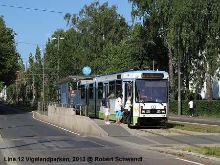
Trikk
Oslo's tram system, cutely called
[elek]trikken has hardly changed over the last 10 years. The section
from Disen to Kjelsas, which had suddenly been closed then, has
reopened, though this section has some worn-out track, indeed.
Otherwise the routes are pretty o.k. and the trams get through the
city at an acceptable speed. Most stops have some sort of platforms,
sometimes integrated into the pavement, although stepless boarding is
a privilege for some passengers only, anyway. Most lines are operated
with the older single-ended Duewag trams, reliable, but in this
respect outdated and often too small. The Ansaldo trams, however, are
double-ended and therefore required for lines 17 and 18, which don't
have a turning loop at Rikshospitalet, as well as line 13 to go to
Jar (see below). The Ansaldo trams, however, have proved very
unreliable, so there is a continuous shortage of trams, and on line
13, a minibus carries the few passengers from Lilleaker to Jar, when
a Duewag tram has to help out. I assume the same is true on lines
17/18 between John Colletts plass (loop) and Rikshospitalet.
Strangely, the city or whoever is in charge now, has not taken a
decision yet to order new (and reliable) and urgently needed rolling
stock for the tram system.
I do not understand why line 13 needs
to go to Jar and even to Bekkestua. To do so, a sophisticated
grade-separated junction was built east of Jar, and the rebuilt metro
line was equipped with both third-rail and overhead catenary. This
shared section can only be operated with Ansaldo trams, of which
there aren't enough, as the older trams are not equipped with the
metro's control system. At the moment, this wouldn't be necessary
anyway, as the short section between the junction and Jar is operated
separately, the tram uses the southern track, and the T-bane the
northern (thus operated single-track through the station), this
leaves a very unpractical situation for transferring passengers, as
the trams actually terminate at a special side platform to the south
of the metro station. To avoid building a low-level platform next to
the high-level metro platforms, Ringstabekk station will not be
served by trams once these go through to Bekkestua. At Bekkestua, the
defintive terminus for the trams, there are two stub tracks between
the metro tracks, so here transfers will be quite convenient. But I
wonder whether this sort of mixed tram/metro operation is worthwhile
with all the technical difficulties and investment in infrastructure
it required. My choice would have been for a good interchange station
near Øraker.

But the worst impression left was the
outside appearance of the Ansaldo trams. The cover of the bogies as
well as the painting of the trams as such is worn out and rusty, very
neglected. This may be due to more serious problems the workshops
have to deal with (and the inavailability of the paintshop formerly
located at Avløs depot).
The tram system hasn't been extended
for a while, a line from Sinsen to Tonsenhagen had been planned for a
long time, but has not materialised. Currently a new avenue is being
built along the seafront near the Opera House, and tram tracks should
run in the middle of it, although it is not clear yet whether this
route would replace the current line 18/19 on their way into the city
or complement it.
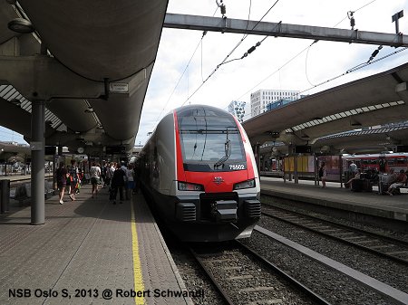
NSB Suburban Rail (Lokaltog)
A lot has been invested in the NSB rail
system in recent decades, both in infrastructure and in rolling
stock. Many sections in or near Oslo have been quadrupled by building
long express tunnels, although 2-track bottlenecks remain between the
four-track stations in the central area, Oslo S, Nationaltheatret,
Skøyen and Lysaker. Routes are now properly numbered, so that the
system is much easier to understand, with L1 and L2 providing a local
service every 30 minutes, and L12 etc. an express service skipping
some inner stations. R10 etc. run even further out into the region.
There are even maps available with these routes, and these maps even
show the zone boundaries clearly (some stations of the Lokaltog
system are outside the 4-zone Ruter system!).

While local services
are mostly operated with refurbished class 69 trains from the 1970s,
plus some Ansaldo partly low-floor trains (class 72), most regional
services are worked by new Stadler FLIRT sets (classes 74+75), which
due to a different front and a rounded belly look slightly different
from the typical FLIRT, but inside they can easily be recognised as
such. The Ansaldo trains offer a similar travel comfort to that of
the FLIRT, but their green and silver livery plus green interior
makes them look very Italian and like an outsider among the otherwise
red/black livery of most NSB trains. Integration between Lokaltog and
T-Bane is much better at Nationaltheatret than at Oslo
Sentralstasjon, where the platforms have been set back towards the
east since the cross-city tunnel was opened in 1980, while the metro
station lies to the north of the railway station (the tram stops,
however, are on the western side and also require quite a long walk
to reach a Lokaltog!).
LINKS
Ruter (Timetables etc.)
Oslo T-bane & Tram at UrbanRail.Net (incl. maps)


