 Knowing that Brisbane and the Queensland government are obsessed by buses and the construction of busways it is actually surprising that it also boasts quite a decent suburban rail network. But a first stroll through the city centre reveals its “real face” - this is bus capital! You can't see them at first, only very few streets in the CBD actually have bus stops, until you come across a large square at the end of Queen Street, with a big hole which acts as a 3-lane ramp on which hundreds of buses enter or leave the underground bus labyrinth built beneath a huge shopping mall (the bus boarding platforms are integrated into a large food court). To provide more capacity, another underground bus station opened nearby beneath King George Square, in front of the Town Hall. This appears more to be a huge modern metro station. These two centrally located underground stations are just the centrepiece of a growing network of busways, but busways of the super-highway type, i.e. long sections of complete grade-separation, including tunnels and viaducts and full-scale stations. While busways may certainly have several advantages, I personally believe that the policy is going in the wrong direction.
  The biggest advantage is without doubt the one-seat ride from the CBD to your home, at a speed which is probably higher than any other possible transport, at least as soon as the bus is on the dedicated busway. But to achieve this exclusive, almost taxi-like service, you need to provide an extremely large amount of different bus routes to reach every corner of the urban and suburban sprawl, which results in a network layout which is impossible to illustrate (at the Transit Information Centre they admitted that they cannot print a bus map because there are so many lines – anyway, they don't even print a map for the central area or for individual suburbs either....). As the enormous flux from the suburbs into the CBD and back home again occurs only during peak hours, I observed MANY buses leaving the central area almost empty during daytime hours. Of course, you cannot have 500 bus routes running every 10 minutes during the day, but if the frequency is not good enough, no occasional rider bothers to wait for that bus. So while regular CBD commuters will know which bus they take and from where, the “system” is useless for occasional riders (not to talk about visitors not familiar with many place names). Even on the busways it is actually not really clear where all these buses go to, as there are so many different lines passing through that even the experienced traveller loses control, inbound it is always easier as most go to the CBD. I don't know about costs, but I cannot really believe that paying the salary of all the necessary bus drivers is not a strong argument against this sort of transportation. In general, the bus fleet appeared more modern than for example in Auckland, and some buses were even powered by natural gas. Still exhaust fumes extraction from the tunnels must also be an important cost factor.
So while I admit that riding a bus on one of those bus-highways is a rapid form of transport, I think it does not help to create a proper system, as a “system” needs to be simple and understandable for everyone.
 But as I said in the introduction, Brisbane also has quite a nice suburban rail system which works pretty well, with most routes being served every 30 minutes (also on weekends!), with some sections carrying two lines. Many sections in the central area have three or four tracks, so for the time being there is no real bottleneck, especially as regional rail traffic that shares some sections is not too important. The Airport to Gold Coast Line is somewhat different from the other typical suburban rail lines: the partly single-track airport access was built with private capital and therefore has a special fare, from Eagle Junction south the trains can be used with normal tickets (see below). South of Park Road station, the Gold Coast trains run express to Beenleigh (some stop at a few intermediate stations, too), from where the line has a more regional than suburban character anyway. The Queensland Rail suburban system used to be branded CityTrain (and this is still shown on some trains), but for some unknown reason this name is no longer used.
 The fleet includes three different generations, the oldest still being the most strongly represented, but having been refurbished, they offer almost the same comfort as the newest series, all with air-conditioning and acoustic station announcements, the new ones also with visual announcements. Operation and dispatching appears a bit more old-fashioned than in Melbourne, there is a second man (I think I have only seen male drivers and conductors...) always in the cabin of the second trainset (most trains are operated as two 3-car sets), and there is an “invitation” saying “Doors closing, stand clear!” They also announce the next station and which side the platform is on. The floor height only matches the platform height in a few stations, sometimes when there is a slight curve, it can get quite high! The conductor has a manual ramp for wheelchair access.
 The stations are generally in a good shape, some have a 1930s appearance, while others have been rebuilt completely, and now feature lifts and footbridges. As in Melbourne, all stations have generally usable toilets. Many stations still have older Queensland Rail signs, strongly faded and sometimes impossible to read the name. Others have been replaced with a new design, not too appealing in my opinion, but the newest ones have a strong orange stamp, for TransLink, the Transportation Authority of Southeast Queensland. So, large orange signs now at least hint car drivers at existing stations, but unlike in Melbourne, the colour does not reveal the mode, thus a busway station looks the same as a rail station. A feature worth copying in other places is the automatic acoustic pre-annoucement of the next train 2 minutes before its arrival, like “The next train on platform 2 is a City and Ferny Grove service and will arrive in approx. 2 minutes” or similar.
One thing I hated in the beginning, and finally accepted it although I'm still not convinced of is the new fare system. Paper tickets are still sold for single rides, only. Anybody else needs to acquire a “go card”, a smartcard that can be used in the entire Translink area which is rather large, probably some 150-200 km in the north-south direction. This area is divided into 23 zones in each direction from Brisbane CBD and the corresponding fare is deducted from the go card, and therefore one has to touch on and touch off at all times. The first problem is that one never really knows how much it costs, I tried to understand, but couldn't. At least, it was generally less than I expected. I couldn't find out either how long the system accepts a touch-on as a continuation of the previous trip, and in many cases the system doesn't seem to understand where you are going... One reason for this is that the rail stations outside the central area are open-access stations, so you need to touch on and off as you walk onto the platform through one of several possible entrances (luckily, unlike Melbourne, there are several entrances!), there are even touch-on machines in the middle of the platform. So, in my case (I admit it is not the most typical), I touched off at the final stop, and a few moments later I touched on again to go back into the city and the system would accept my return journey as a continuation of the previous journey, so often, when I touched out in the city centre I wasn't charged for the return trip! Anyway, you get other discounts, like off-peak, and if you use it a lot in one week, it gets half price, etc. That's what I mean, that you never really know how much you will pay.
Implementing such a system costs millions of dollars, so why not implement it properly? Why maintain single paper tickets, which require all accesses in the central areas which have proper ticket barriers to be manned at all times to open the gates for paper ticket holders, also the Airport Train issues paper tickets! Due to the lack of proper ticket gates in outer stations, ticket inspections are still necessary on the trains, and I had them on the first train I took! So the problem of fare evasion persists.
 When I went to Gold Coast, I got off at Nerang and was picked up by a local fan, the typical situation when you forget to touch out! And I forgot. I wasn't sure how I could solve this situation, but when the guy dropped me at Varsity Lakes (the southernmost station of the system), the ticket office lady told me, I should simply touch out first at the machine inside the station (this one has proper gates, though open....), and then touch on again to return to Brisbane. This means that I “finished” my journey three hours after getting off the train and it still accepted it as valid. Anyway, as I wrote for Melbourne, I prefer simple tickets which for a set price say where you can go, and with the option of unlimited rides. The Brisbane system doesn't help to get more people out of their cars – the whole philosophy behind “day/weekly/monthly passes” is that you are more likely to use public transport if you already have a ticket (at a fair price!), and the feeling that you made the most of it. Having to pay a new fare for each trip makes you always think twice whether you should actually do it.
Brisbane at UrbanRail.Net
 When I left my accomodation near South Yarra station for the first time last week to explore the city's urban rail system, I thought, the area looks very much like London, but with a Viennese tram system, and indeed there are several similarities, most of all the density of the network, with trams through every second street, a quite frequent service, a mixture of old and new vehicles, etc.
  The Melbourne tram system, certainly a paradise for any tram fan, has everything a tram system can have. Vintage tram vehicles not only operate on the FREE city circle line introduced primarily for tourists but also popular with locals as it is free (though slow and often packed! - labelled line 35), but they also run regularly on line 78/79 through the busy Chapel Street in South Yarra and Prahran, and line 30 (which is a reinforcement service along LaTrobe Street). Besides these, there are four different types of vehicles, two older high-floor trams and two standard low-floor trams well familiar to Europeans, the Siemens Combino and the Alstom Citadis (with some newer ones first leased from Mulhouse but now permanently staying down under). The Combino trams surprised me for the small amount of seats they offer, I'll have to check at home whether the European versions have the same seating arrangement. The other weak point is that they are rather loud, probably partly due to the loose wheels they have in the middle, but they are always loud rattling along the streets, both when you're inside and outside. The Citadis seem to be slightly more quiet and offer much better seating, so in this case I would opt for the French solution. But anyway, I was told that Bombardier trams have been ordered as the next generation.
 As far as alignment is concerned, the network also includes everything one might think of, from street-running in mixed traffic with cars, to marked-off lanes, to reserved right of way, to railway alignments taken over from former suburban railway lines (line 96 to St Kilda, and 109 to Port Melbourne). Sometimes boarding is from street level (car drivers generally stop, and sometimes I observed tram drivers telling them off if they didn't or even writing down their number). When the doors open, a sign like that at pedestrian crossings folds out and trams have flashing lights on. Generally my impression was that traffic among cars runs smoothly and that it is not too dangerous, as obviously everybody driving around here has grown up with trams, so it's not a strange element for them in road traffic. Sometimes there is a narrow boarding area in the middle of the street protected by a fence, but it's very narrow, so one doesn't really feel comfortable waiting in that space. In recent years many stops have been completely rebuilt and are now proper “platform stops” and also shown as such on line panels. These mostly have electronic next-tram indicators. Generally, all stops have a proper stop sign (in green, of course, like everything related to the trams), and mostly there is also a timetable displayed, but sometimes I found it missing. As is normal with street-running systems, the punctuality is somewhat at random, sometimes I was surprised how much on time a tram arrived, and sometimes you wait for a while and then you get two or even three vehicles arriving at the same time.
  The termini are mostly very basic, and generally one single-track in the middle of the road. This may be quite a problem during peak service, when the stop is still occupied by the previous tram, or the stop has to serve even two different lines. At some termini, there is a set-down point still in the double-track section, so at least passengers can get off instead of waiting to enter the terminus proper. I was surprised that several stub termini located perpendicularly to another passing tram line do not have a track connection to that line, which is common in other places to facilitate diversions in case of disruptions.
 Swanston Street in the downtown area is probably the busiest tram route in the world (maybe Karlsruhe's Kaiserstraße is similarly packed and therefore now gets a tunnel underneath), with a total of 9! lines running through there – and 7 of these terminate at Melbourne University, which has quite a peculiar layout to cope with so many reversing trams (all bidirectional and single units): there are three reversing sidings between the running tracks, located one behind the other; if I have observed it correctly, an arriving tram goes into the next available siding, but obviously cannot remain there long either. Despite this heavy traffic on Swanston Street, the system works fine, but generally there are far too many stops, basically on every street corner, and sometimes in between, too. Being so many, the maps don't show all the stops, not even the line panels do. So for better orientation, the stops are numbered. But the stop signs also show the name of the stop (basically the crossing street). The numbering system is not completely useful, although it helps, of course, but with the construction of platform stops, the total number has been reduced on some sections, but the numbers remain. Also, the number of the stop can only refer to one line, and when there are two or more lines running along the same stretch, the numbers on one line may get out of order. Usually the numbers run from the city centre to the suburbs. The stops on the lines that were extended into the Docklands area had to be given negative numbers, well, in reality its D1, D2, etc.
 The trams share the fare system of the Metro and bus system, but recently it was decided that all tram routes can be used with a zone 1 ticket to simplify things. On outer stretches (part of the overlapping zones) the cheaper zone 2 ticket can also be used. Officially, and I was told so today by a ticket inspector, everybody has to validate their Metcard each time they board, but nobody does it as it doesn't really make sense, but those using a Myki smartcard have to touch on and off, which takes quite a bit more time, so it seems almost unimaginable that the new system will one day work as the only ticket, as it would delay boarding and alighting enormously. And they will still need ticket inspectors (and inspecting Myki tickets also takes much longer as they have to introduce it into their control device!). I heard from some people that the extremely costly introduction of the smartcard system was more of a political decision than an economic one, especially as the distribution of the revenue seems to be working fine as it is now.
 While the general appearance of the stations is quite good, all clean and tidy, and most with usable toilets, I was often annoyed by the bad accessibility. Probably thought to create a properly separated paid area, most platforms are enclosed by fences, so one often has to walk a long way to the actual entrance when an opening at the other end of the platform would be easy to make and save passengers a lot of time. Therefore I didn't understand either why they don't put proper ticket gates, if the access is channelled through a small slot anyway. At many stations with side platforms, the two platforms are not really connected, but one has to walk to a nearby level crossing to get to the other side (well, I have to admit, that being used to right-hand operation, I sometimes mistook the platform until I realised....).
 There are basically three different types of trains, although some of the older Hitachi trains are still in service during peak, but I only spotted a few and never got a chance to actually ride them. The second-oldest are probably the largest number, those are the refurbished Comeng trains. They are quite pleasant, except for their peculiar door handles. Unlike on the newer trains, which have a normal button to open the doors, these have a knob, and you have to manually slide the doors open, which can be quite hard, especially if you carry things in your hands.
 The design of the three underground stations is quite European, in fact they could be S-Bahn stations in German cities like Frankfurt, Stuttgart or Munich or even Hamburg, which were built at the same time. There is another covered station at Box Hill (with a shopping mall on top), but this is very basic and not really appealing. Many of the surface stations preserve a nice old station building.
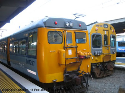 The JVL, which is actually the original route of the North Island Trunk Line towards Auckland, is a steep single track line with various tunnels and passing loops. It is basically separated from the other lines from Wellington Station, although the tracks it normally uses are linked to the other tracks there. This line has recently been upgraded in preparation for the new Matangi trains about to enter service; unfortunately I only spotted one of them on a test run. Meanwhile, this line is operated with EMUs from the 1950s. It is a quite picturesque line as it winds its way up the mountain and provides some nice views of the bay.
 The PPL will be extended further north on 20 February 2011 from Paraparaumu to Waikanae and will change its name to the Kapiti Line (named after the region it serves), although the new timetable still has the “PPL” abbreviation. For the extension of the suburban service the line was doubled and electrified, and a new, though simple station built at Waikanae. The PPL is mostly double-track, although there is a single-track section with five tunnels along the coast between Muri and Paekakariki. There are two longer tunnels after the PPL diverges from the HVL, which were built in the 1930s to create a more direct and less steep route for the mainline to Auckland. The PPL route is also served by one daily passenger train to and from Auckland, “the Overlander” (12 hours!), as well as the “Capital Connection” a daily commuter train to/from Palmerston North.
 Wellington is not only NZ's leader in suburban rail, but has also the most environment-friendly bus system, as it boasts quite a large trolleybus network, apparently the only trolleybus system worldwide that operates on the left side. Unfortunately I didn't get a chance to explore it properly – simply because the trolleybuses remain in the depot on weekends for some strange reasons. While some lines are then operated with diesel buses, others don't operate at all. Still, the city's main transit corridor is used by numerous diesel buses also during the week, which often form clusters which reduces their travel speed through downtown.
 Last but not least, the Wellington Cable Car deserves a mention, too, as this is authentic urban rail. It is also a major tourist attraction as visitors can enjoy a great view from the top and start their downhill walk through the Botanical Gardens, but it is also used by many locals to climb up the steep mountain from Lambton Quay, the city's major shopping street. It is called a “cable car” as it was indeed operated in the early days like the San Francisco cable trams, but it was rebuilt into a normal Swiss-type funicular in the 1970s.
 Christchurch, however, has a heritage tram line, which runs in a circle around downtown on a new route opened in 1995. At present this service is being extended to the southern parts of the city centre and the Polytech campus. As of now, it is only a tourist attraction, with no single tickets available for spontanous short trips; a 2-day ticket, which allows unlimited hop-on hop-off costs 17 NZD (some 9 €). Locals can, however, buy an annual pass to use the tram. In any case, walking is in most cases faster than taking one of the three trams which run daily every 8 minutes. With the new extension and further proposals, the basis is being laid for what may one day become a modern light rail system.
 The two lines running south from the city centre take two different routes as they leave Britomart, but further south rejoin and most trains continue to Papakura. Only a few trains continue even further south on the main line to Wellington to terminate at Pukekohe. This network layout has the curious effect that actually the headway on the outer section, with trains about every 15 minutes, is better than on some inner sections, notably the Eastern Line via Sylvia Park. The stations south of Newmarket, however, are now also served by the Onehunga Line, a branch re-opened in 2010. The Western Line runs every 15-30 minutes, with every other train terminating at Swanson. This line used to be mostly single-track, but has been doubled in recent years all the way until just past Swanson. At the same time, all stations have been modernised or completed rebuilt, the one suffering the most changes being New Lynn, which was put into a trench to eliminate an important level crossing. Now only a few level crossings remain, and at some stations, also passengers have to cross the tracks. Provisions have also been made for electrification, and along some sections masts can already be seen along the tracks. The Southern and Eastern Lines, which have been double-track for a long time, have an older appearance, but several of the busier stations have already been modernised recently. Infrastructure work for electrification has also started here. Another major work completed in this upgrading process is the new station at Newmarket, an important shopping area, and Auckland's second „downtown“. To allow trains from the Western Line to change direction here, the station now has three tracks, but in the future it will also be possible to run direct trains from Grafton towards Britomart as the junction north of Newcastle is now a full triangle.
 At present the service is provided with either diesel multiple units or push-pull trains with diesel locomotives (which look very much like shunting locos to me). The latter are much more pleasant as at least the noise inside the carriages is acceptable, whereas the DMUs are horribly loud. Both types cannot compete with electrically powered trains when it comes to acceleration, not to mention the exhaust fumes they deliver when leaving a station. Therefore it was high time for Auckland to go for full electrification! Let's hope that the new electric trains were designed to match the platform height, as the present rolling stock requires a high step up to climb into the vehicles.
 The re-opening of the Onehunga Line must have been rather a political decision than part of an overall effort to create a rapid transit system. It was probably cheap to do, as the track was already there, but the line is only single-track and very slow, with numerous level crossings on its short route. It certainly served some politicians to say, hey, we did something. It has been proposed to extend the line to the airport, but this would then really give a rather embarrassing image of the city if tourist had to take this „airport express“ into the city. It would probably take as long as the current airport bus.