Sunday, 28 July 2013

OSLO T-bane & Tram

This was my first visit to Oslo after almost 10 years. I had come in autumn 2003 in preparation for my book 'Metros in Scandinavia' (still available!), so I focussed mostly on the T-bane system, although I did a bit of tram riding, too. This time (23-28 July 2013) I had a closer look at the tram system as the visit was in preparation for my forthcoming 'Tram Atlas Northern Europe'.

All in all, Oslo has quite an extensive urban rail network considering the size of the city (around 630,000 inh.) and its metropolitan area (about 1 million). There is a dense tram network that primarily serves the central area, a metro (T-bane) that primarily links the suburbs to the city centre, plus a frequent Lokaltog (suburban & regional rail) network for the larger urban area and region.


T-bane

The most striking difference I noticed since I was here last is the completely renewed rolling stock on the T-bane. Back in 2003, all trains were still red, some older than others, and in the meantime, all have been replaced by new Siemens 3000-series 3-car sets. These are similar to the V train on the Vienna U-Bahn, wider, of course, as Oslo's T-bane trains are among the widest in the world at 3.2 m, allowing 3+2 seating in one row. Instead of red, the new trains were painted white with grey doors, but I guess that this was not a very good decision, as the white colour after a few years looks rather dirty, which becomes especially apparent when one of the older 3-car sets is coupled to a brand new one that still looks beautifully white. In any case, I would have preferred a red livery, much more noticable as a company brand, whereas the white trains look pale in the landscape, and I realised on the first day, which was covered with white clouds, that there is no contrast between train and sky. I would have to come back in the dark winter to see if the white trains look shiny then. Otherwise they are prefect, smooth ride, nice spacious interior, quiet, but probably too expensive for 'normal' cities (due to steep gradients they need more motorised axles and advanced brakes as well, I suppose) and that's why Siemens has recently come up with the trashy Inspiro metro train instead of developing this train to be used as their standard metro train.

The T-bane often reminds me of the Frankfurt U-Bahn. With rather long trains it carries large crowds, but despite the metro-like sections it does not really appear to be a proper metro. Except for line 1, all other sections are now grade-separated and operated with a third-rail power supply, but the route alignments, often very winding and steep) and especially the standard of the surface stations make it look rather like a typical German Stadtbahn: most surface stations are just an asphalted high-level platform with little more than a small shelter (again, I have never been here in the winter, but I guess people know their timetables well to avoid extra waiting in the cold...). Some have recently been upgraded along with a line upgrade (like currently on the eastern leg to Bergkrystallen or the entire Grorudbanen to Vestli), but the upgraded stops now appear to be modernised surface Stadtbahn stops in Frankfurt. The only exception is Ensjø, which has only recently received a more substantial upgrade and is now partly covered (awaiting construction on top of it), but as in many other cases, access to the station from the western side is still via a public bridge, i.e. if you want to get to the opposite side, you cannot get from one platform to the other inside the station, but need to take a detour (in other cases often quite long and badly signed) via a bridge that does not belong to the station complex. Some of the newer surface stations like Sinsen and Bekkestua at least have an overall roof structure with wooden elements, but cold winters may also have suggested fully encased stations here (like Kalasatama in Helsinki). Some of the underground stations, though pretty metro-style in layout, are not too pleasant, my negative favourite is Trosterud, which I renamed Trostloserud (trostlos in German is desolate). Luckily Carl-Berners-plass has been refurbished a bit with coloured glass panels, but the overall inpression is still that of a damp cavern, and a ceiling other than black would brighten the entire space up enormously (the same is true for Nationaltheatret). My favourite station remains Stortinget with its large and clearly laid out central vaukted hall, the wide ramps down to the platforms and an easily distinguishable colour scheme. Even the rather new and elegant Nydalen station appears very badly lit.


Line 1 up to Holmenkollen and Frognerseteren is a different case altogether. As a local expert told me, decisions in Oslo are not always predictable and rather spontaneous and this is probably how the Holmenkollbanen also became a 'metro' line with third-rail power supply. Ten years ago, it used to be mostly operated by the unpopular 2000-series, but now it is also operated by the Siemens 3000-cars, unsuitable for this line in many respects. First of all, the platforms, though somehow upgraded a few years ago, are too short for the 3-car trains, so only the doors in the first two cars can open. In a very user-unfriendly way, this policy is also maintained at Holmenkollen station, where the platforms were built for 6-car trains! and where most passengers (tourists that go to the ski jump) get off, completely confused by the fact that the doors don't open in the third car (though announced also in English several times on the route), but there can't be a technical or logical reason why the driver shouldn't open all doors at this station. Precaution, in case he/she forgets to switch it back to selective opening for the following stops? I would think that in a high-tech country like Norway this should actually be done automatically by the operation control system.

In any case, I think that the Siemens trains, good as they are on proper metro lines, are not the ideal choice for this route. They virtually torture themselves up the winding route at the lowest imaginable speed, both up and down, and leaving quite a wide gap at many platforms, as normal metro cars are simply too long for such a winding route. Ten years ago, there was some discussion whether the Holmenkollen line should rather get connected to the tram system. Technically, I guess it would have been wiser to use some sort of articulated light rail cars like the Alstom RegioCitadis. From a passenger's point-of-view it is certainly better to have it connected to the metro tunnel, but as only 3-car trains can be used, while on all other lines 6-car trains are the standard during most of the day, line 1 doesn't fit properly into the shared (overloaded) tunnel headway (and therefore for some time they were actually curtailed at Majorstuen, but passengers claimed a through connection into the city). Whichever route would be chosen to bring it into the city centre as a light rail line on existing or new tram tracks, this would certainly increase travel times. On the other hand, I found it quite a luxury that all line 1 trains go to the Frognerseteren terminus, which is only useful for walks through the woods, and trains were close to empty even on the best days of summer beyond Holmenkollen. The last houses are at Lillevann, but even that stop seems to be barely used during daytime, so terminating every other train at Holmenkollen (and opening all doors there) would just be as fine. It is not quite clear either why a third rail power supply was necessary on this line after more than a 100 years of overhead wires. The route still has many level crossings, where generally an overhead equipment seems safer, but I guess that maintenance is easier, especially in harsh winters, with a third rail. All level crossings are protected by automatic barriers. Otherwise, the formerly used switching from overhead to third rail, as has also been done in Rotterdam for many decades now, could have persisted in Oslo, too. I assume that the visual impact of the overhead equipment was not an issue here, as it is in many new tram cities, as the overhead lines had been on this line longer than most houses alongside it.

The junction where all western lines converge near Majorstuen station reminded me a bit of some 100-year old junctions on the London Underground. All branches diverge in a grade-separated junction, but especially outbound L2/5 trains crawl over the L1/6 tracks. Inbound trains often have to line up before getting into the busy tunnel. There are plans for a second city tunnel plus a new line to Fornebu (old airport area), and this would require a complete reconstruction of Majorstuen station into an underground transfer station, requiring new approaching tracks, but this could be another 20-30 years before it is built.


In general I was amazed that the T-bane runs its normal timetable also during the summer holidays, while the tram service (much busier on some routes like line 12 with tourists) was reduced from a normal 10-minute to a 15-minute headway. Most T-bane trains ran with 6 cars, when a 3-car set would have been more than enough.

What has also improved over the last years is the Ruter fare system. Previously those stations located in the municipality of Baerum, west of Oslo, were outside the Oslo zone and an extra fare was required. Now all T-bane stations and tram stops are within zone 1 (Oslo), so a 24-hour ticket for 80 NOK (some 10 EUR) or a 7-day pass for 220 NOK is enough to explore the urban rail system. And unlike other Norwegian cities, these passes are also good on the NSB suburban rail network (not on the airport train Flytoget – but you can get to the airport also easily on an NSB train! > 4 zones). Now mostly electronic tickets are used, a Reisekort for regular passengers, but available without an extra charge also when you buy a 7-day ticket, or an Impulskort for single tickets or 24-hour-tickets bought from vending machines or kiosks. Oslo, however, does not really take full advantage of these electronic tickets, as they just need to be validated once just like paper tickets used to. So, there is no exact statistics how many passengers are carried by which operator, in many other cities the primary reason to introduce such a system in order to distribute the revenue accordingly. Metro stations in the central area have proper ticket gates, but these were not in use (maybe they are at certain peak hours – but this would require at least one manned access as there are still some paper tickets left). The only ticket inspectors I saw in five days were at the ferry terminal on a nice sunny day...

Trikk

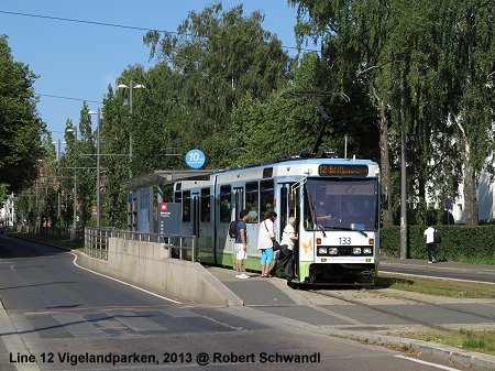
Oslo's tram system, cutely called [elek]trikken has hardly changed over the last 10 years. The section from Disen to Kjelsas, which had suddenly been closed then, has reopened, though this section has some worn-out track, indeed. Otherwise the routes are pretty o.k. and the trams get through the city at an acceptable speed. Most stops have some sort of platforms, sometimes integrated into the pavement, although stepless boarding is a privilege for some passengers only, anyway. Most lines are operated with the older single-ended Duewag trams, reliable, but in this respect outdated and often too small. The Ansaldo trams, however, are double-ended and therefore required for lines 17 and 18, which don't have a turning loop at Rikshospitalet, as well as line 13 to go to Jar (see below). The Ansaldo trams, however, have proved very unreliable, so there is a continuous shortage of trams, and on line 13, a minibus carries the few passengers from Lilleaker to Jar, when a Duewag tram has to help out. I assume the same is true on lines 17/18 between John Colletts plass (loop) and Rikshospitalet. Strangely, the city or whoever is in charge now, has not taken a decision yet to order new (and reliable) and urgently needed rolling stock for the tram system.

I do not understand why line 13 needs to go to Jar and even to Bekkestua. To do so, a sophisticated grade-separated junction was built east of Jar, and the rebuilt metro line was equipped with both third-rail and overhead catenary. This shared section can only be operated with Ansaldo trams, of which there aren't enough, as the older trams are not equipped with the metro's control system. At the moment, this wouldn't be necessary anyway, as the short section between the junction and Jar is operated separately, the tram uses the southern track, and the T-bane the northern (thus operated single-track through the station), this leaves a very unpractical situation for transferring passengers, as the trams actually terminate at a special side platform to the south of the metro station. To avoid building a low-level platform next to the high-level metro platforms, Ringstabekk station will not be served by trams once these go through to Bekkestua. At Bekkestua, the defintive terminus for the trams, there are two stub tracks between the metro tracks, so here transfers will be quite convenient. But I wonder whether this sort of mixed tram/metro operation is worthwhile with all the technical difficulties and investment in infrastructure it required. My choice would have been for a good interchange station near Øraker.


But the worst impression left was the outside appearance of the Ansaldo trams. The cover of the bogies as well as the painting of the trams as such is worn out and rusty, very neglected. This may be due to more serious problems the workshops have to deal with (and the inavailability of the paintshop formerly located at Avløs depot).

The tram system hasn't been extended for a while, a line from Sinsen to Tonsenhagen had been planned for a long time, but has not materialised. Currently a new avenue is being built along the seafront near the Opera House, and tram tracks should run in the middle of it, although it is not clear yet whether this route would replace the current line 18/19 on their way into the city or complement it.

NSB Suburban Rail (Lokaltog)


A lot has been invested in the NSB rail system in recent decades, both in infrastructure and in rolling stock. Many sections in or near Oslo have been quadrupled by building long express tunnels, although 2-track bottlenecks remain between the four-track stations in the central area, Oslo S, Nationaltheatret, Skøyen and Lysaker. Routes are now properly numbered, so that the system is much easier to understand, with L1 and L2 providing a local service every 30 minutes, and L12 etc. an express service skipping some inner stations. R10 etc. run even further out into the region. There are even maps available with these routes, and these maps even show the zone boundaries clearly (some stations of the Lokaltog system are outside the 4-zone Ruter system!). 


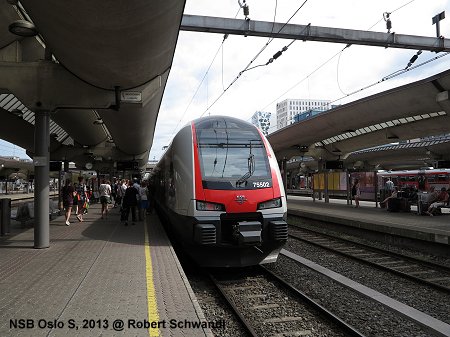
While local services are mostly operated with refurbished class 69 trains from the 1970s, plus some Ansaldo partly low-floor trains (class 72), most regional services are worked by new Stadler FLIRT sets (classes 74+75), which due to a different front and a rounded belly look slightly different from the typical FLIRT, but inside they can easily be recognised as such. The Ansaldo trains offer a similar travel comfort to that of the FLIRT, but their green and silver livery plus green interior makes them look very Italian and like an outsider among the otherwise red/black livery of most NSB trains. Integration between Lokaltog and T-Bane is much better at Nationaltheatret than at Oslo Sentralstasjon, where the platforms have been set back towards the east since the cross-city tunnel was opened in 1980, while the metro station lies to the north of the railway station (the tram stops, however, are on the western side and also require quite a long walk to reach a Lokaltog!).


LINKS

Ruter (Timetables etc.)

Oslo T-bane & Tram at UrbanRail.Net (incl. maps)


Monday, 15 July 2013

LIEPAJA & DAUGAVPILS Trams


Besides the capital Riga, two rather small Latvian cities maintain modest tram systems, which I visited on my Baltic tour in July 2013 in preparation for my Tram Atlas Northern Europe, planned to be released in autumn 2013.


LIEPAJA

Liepaja is a coastal town in western Latvia, once an important Soviet military base, and now more of a seaside resort, home to some 87,000 people. The town's only line is just 7 km long, but as the urban area stretches mostly north-south, the tram can take the role of a primary axis through the town. It runs from the industrial area occupied by a metallurgical factory to the railway and bus station (there are only two passenger trains a week to Riga!), and then south towards the town centre located on the south bank of the so-called Trade Canal. The most central stop is called Kurzeme (Courland) after an adjacent shopping centre, although the square it is placed at is actually called Rožu laukums (Rose Square). It continues south and used to terminate at the central cementary until recently, when a new 1.6 km section was added at the end of May 2013 – this was in fact the first new tram line built in the Baltic States since 1984!


Liepaja's 1000-mm gauge tram line is in a relatively good shape. It is served by an almost homogenous fleet of Tatra KT4 vehicles, some original ones from Soviet times, and some second-hand trams purchased from East German cities such as Erfurt and Cottbus (inside they still display many German stickers like 'Notbremse' or 'Türöffner'). All trams are covered with full adverts, which gives each car a special identity, while it is not clear whether the tram company actually has a colour scheme in its cooperate identity. Some decorative elements at the new stops plus the website make me think that it could be green (there are also some green buses, while most other buses run in their original livery revealing they were purchased from some Swiss and other Western cities).


The new extension was, of course, a clear sign that the modest line will be maintained, and currently also upgrading of the old sections is in full swing (in summer 2013, the section between Kurzeme and Livas laukums is operated only on one track while the trackbed of the other track is completely renewed) but trams still keep running every 7-8 minutes, which I consider quite a good offer for such a small town. Most sections of the line are in fact on a dedicated sort of right-of-way, although this is not always clearly defined and cars may invade the reserved space, but generally the operation was fluid, albeit not too fast. The only sections with mixed traffic are the one across the bridge over the Trade Canal and along Ventas iela on the new section, where the roadway was raised at the Vainodes iela stop to slow down car traffic and allow better boarding. Most stops have (rather low) platforms, but at some boarding is required from street level. In any case, the platforms will still be too low for any kind of low-floor vehicles.


For a mere 1.50 LVL (approx. 2.13 EUR) one can use the tram and all buses during one day. A single ticket without transfer bought from the driver costs 0.50 LVL. Unlike other Baltic cities, which have invested a lot in the implementation of a smartcard system, Liepja maintains a German-style ticket system, i.e. you buy a book of single tickets or a day ticket at a kiosk and stamp it in the tram/bus. Tickets bought from the driver also need to be stamped!


DAUGAVPILS

Located in the far east of the country, Daugavpils is Latvia's second largest city, with some 100,000 inhabitants. The city is predominantly Russian-speaking (although Latvian remains the only official language), and its tram system is also typical Russian in many ways. I happened to be there on a Saturday, when the rolling stock in service was almost exclusively KTM 5 vehicles seen in many Russian cities as well. Although well-painted on the outside, they looked rather worn out and rusty inside, hoping to be replaced soon by new Belorusian trams ordered. So the future of the Daugavpils tram system seems to be secured, too. The tracks were in a rather bad state, but also here, track renewal work was going on between Ventspils iela and Saules veikals, with only one track available for operation. Line 1 was running pretty frequently for a Saturday afternoon, and even line 3 out to Stropi was quite busy with people going for a swim in the lake there. While line 1 runs every 7-8 minutes on weekdays, the other two lines have rather unusual headways, line 2 every 28! minutes and line 3 every 25 minutes, which results from the existing passing loops on the single-track sections, I suppose.


Only opened in 1946, the Daugavpils tram system features several single-track sections, notably the outer sections on lines 2 and 3. Interestingly, the stretch shared by all three lines is not in the city centre (which would be between Tirgus and Universitate), but on a section east of the bridge across the railway line. Most sections are separated from road traffic and features some kind of platform, which like in Liepaja, will not be high enough to allow proper level boarding once low-floor trams have been purchased.


While most passengers on St. Petersburg's trams, which I visited a month ago, now use a plastic smartcard to pay their fare, Daugavpils allowed me to experience a typical Russian tram conductoress selling single-trip paper tickets for 0.30 LVL (0.43 EUR).
 
 
LINKS
 
Liepaja Tram (Official Site)
 
Liepaja Tram at UrbanRail.Net (incl. map)
 
Daugavpils Tram (Official Site)
 
Daugavpils Tram at UrbanRail.Net (incl. map)


RIGA Tram


In preparation for my forthcoming 'Tram Atlas Northern Europe' I visited the Latvian capital for three days in July 2013 (3-5th).

Like Tallinn, Riga has both a tram and a trolleybus system. Although trolleybuses will also be featured in my atlas, I'll focus on the tram system here, as urban rail is the subject of this blog.


Riga's tram system is the largest in the Baltic States, and Riga is also the largest city in the region. On the map there are 9 tram lines, but this is a bit misleading as two of them do not operate regularly: line 3 offers some 14 journeys a day at no identifiable headway, and line 9 only operates during peak hours. The busiest is line 6, which runs every 7-8 minutes, while line 2 is the least-frequent with a tram every 20 minutes only. On all lines, headways increase notably during peak times and are reduced significantly during daytime off-peak hours. Except for line 5, which runs from a suburb on the west bank of the Daugava River to another on the right bank, all other all-day lines terminate somewhere in the city centre without a proper interchange station between them. Someone coming on line 6 and wishing to continue across the river on lines 2, 4 or 10, needs to walk some 500 m in search for a departing tram, or jump on a line 5 tram for 2-3 stops and then change again. I don't know whether this has always been so, or whether it is due to the restricted use of the new Skoda low-floor trams which only serve line 6, and now partly also line 11. So hopefully, as new trams arrive, lines will be better interconnected to provide improved cross-river service (especially as with the construction of the new National Library on the left bank, this side of the river seems to be gaining importance). In Riga, the introduction of low-floor trams requires an upgrade in the electrical overhead equipment, as older trams use a trolley pole for power collection, while new trams are equipped with a pantograph.


Generally, Riga's tram system is rather old-fashioned, with lots of sections, especially in the more central areas, in mixed traffic with private vehicles and also numerous mini-buses. Trams and trolleybuses only share a short section on line 6 on its way across the railway tracks near Zemitani station. Despite the use of low-floor trams on line 6 and 11, the general concept of boarding platforms seems to be a rather new one in Riga. Only the recently renewed section between 45. vidusskola and the line 6 terminus at Jugla (see photo below) is equipped with proper platforms, the only other stop where I identified platforms was Kurzemes prospekts/Jurmalas gatve on line 4, although the other stops on the outer line 4, which was the last addition to the system in 1984 and has a dedicated right-of-way, as well as other sections on dedicated rights-of-way, have some sort of low platforms too. So, a lot needs to be done to upgrade this system into a modern tramway. The same is true for the track, which requires a complete renewal on most sections, although the Skoda 15Ts cope pretty well and offer quite a smooth ride on worn-out track. Having some sort of bogies between modules, the gangway between two modules occupies almost 2 m leaving only a narrow corridor, too narrow for passengers to stand. With the front bogie placed almost at the extreme of the tram, the driver's cabin is unusually large, and quite luxurious compared to the tiny space available in the older trams.


What I really hated in Riga is the naming convention of stops. In lots of cases the stops in opposite directions carry different names. This is not only a horror for map makers, but must also be confusing when you indicate a stop to someone who may come to visit you. It must also be quite tricky for modern journey planner devices to get this right. There is, for example, a trolleybus terminus called Petersalas iela, where transfer is easy to tram line 5, and while in the inbound direction the tram stop is also called Petersalas iela, in the outbound direction it is Ganibu dambis, whereas the outbound Petersalas iela stop is two stops further west! This is just one of numerous cases, and on the trolleybus and dieselbus network it is the same, of course. For locals, this may have some logic, as the stop name usually refers to the next crossing street, but for the rest of the world it is simply confusing. Even worse, the stops that serve the central railway station and also parts of the old town are sometimes called Stacijas laukums (Station Square) and sometimes Centrala stacija (Central Station), no idea which concept is behind that! Anyway, my proposal is to reorganize the entire Station Square situation by building a road tunnel and establishing a good public transport hub on the surface instead. This would also eliminate the rather unattractive pedestrian tunnels in this area.

Talking about Old Town, Riga's no. 1 tourist attraction: there is simply a stop missing between Nacionala opera and Nacionalias teatris (850 m!!), where the main entrance to the Old Town is located next to the Freedom Monument at Kalku iela/Brivibas bulevar. Older maps even show a stop in this location, and trams often stop there anyway because of a zebra crossing without traffic lights.


All routes are double-track except a short segment at the northeastern end of line 5 and a longer section on the outer line 10, where boarding the tram can become very dangerous, as the stop sign is sometimes actually located on the opposite side of the bidirectional road. A similar life-threatening situation can be found at Tilta iela on line 5, a busy stop, where people change to the trolleybus, but to get off the tram, passengers need to hope that no car is coming from either direction! This type of "stop" should be forbidden by law. If no reserved right-of-way is available, the tram tracks should at least be in the middle to avoid this bizarre and dangerous situation.


What I liked in Riga was the uniform overall appearance of trams and buses, all in a pleasant blue & white colour scheme, only some Skoda trams carry full adverts. What I don't like, though, is that in a Russian tradition, trams, trolleybuses and normal buses (autobus) may carry the same number. Fortunately the mini-buses, a kind of plague in all Baltic cities (a cheap way of organising public transport and keeping many drivers busy, albeit at the cost of immense air pollution!), were assigned 3-digit numbers like 203. Trolleybus lines 9 and 27 operate in diesel mode between the Daugava bridge and the railway station, with the trolley poles lowered, so in the case of line 9 you actually get two different lines 9 crossing the Station Square. Probably most Eastern European passengers have been trained properly to distinguish a diesel bus from a trolleybus, while most westerners would just identify a 'bus'. Unlike St. Petersburg, where trolleybus stops have a special sign, here it is a shared bus sign, where numbers are listed as A 1 2 3 ... for 'autobusi' and T 1 2 3 ... for 'trolejbusi', while 'tramvajs' stops have a different sign showing a tram. Some tram stops, most notably on the renewed Jugla section, have network maps. I didn't see an open customer information office anywhere, so I don't know whether these maps can be picked up. Interestingly, an independently produced diagrammatic map, a bit messy though, with all tram, trolleybus and bus lines was sold at some kiosks. Tram and bus stops are all equipped with timetables, and these are also available in a quite extensive form on the internet.


Riga has also switched to electronic smartcards, but unlike in Tallinn, Vilnius or Kaunas, a 24-hour ticket (1.90 LVL = 2.70 EUR) is available at kiosks in the form of a cardboard one-use ticket (yellow e-talon), while monthly passes or other types can be stored on a blue plastic rechargeable e-talon. Skoda trams are equipped with ticket machines, but they don't issue day tickets, just single tickets or allow the blue card to be recharged.


Besides the tram and trolleybuses, Riga also has an electric suburban rail system, but despite being much more frequent than any other rail service in the Baltics, it is far from being called an S-Bahn or RER. Platforms are hardly higher than the track itself, and the train floor is probably 1.2 m above the top of the rail, which means that even for passengers with unrestricted mobility it can be quite an adventure to climb into the train. Senior passengers are pushed by fellow passengers. Carrying suitcases or prams is reserved for the very sporting guys! Otherwise the modernised RVR 'elektrichkas' are not too bad. The service is pretty busy on the western line to Tukums via Jurmala, the popular beach resort (although there is actually no station called Jurmala, but Majori and Dzintars are close to the town centre and beaches). Besides the bad accessibility of the trains, another criteria that does not allow to call this service an S-Bahn is the lack of a regular headway. Despite being double-track up to Sloka and probably without any considerable freight traffic, the line to Jurmala is not served every 15 or 30 minutes, but at irregular times difficult to memorise. So, to simplify things, trains run about 2-4 times an hour, some to Dubulti, some to Sloka (both in Jurmala) while a few trains continue to Tukums. Other electrified routes radiating from the Central Station towards the south, southeast and north are served less frequently, but also with one train an hour on average. The trains are not included in the urban fare system, although fares a very low by western standards.
 
LINKS
 
Riga Tram (Official Website)
 
Riga Tram at UrbanRail.Net


Saturday, 22 June 2013

ST. PETERSBURG Metro & Tram


After exploring the urban rail systems of Helsinki, I took the modern Allegro train to St. Petersburg.When I visited Moscow in 2010, I was quite annoyed by the lack of order at the immigration procedure. In the U.S. you may find a long queue, too, but it is strictly organised and vigilated, so although you may have to wait, you know you will eventually get there. Not so in Russia (at least Moscow Domodedovo): there is a huge crowd waiting in front of numerous immigration desks, and you just have to keep your elbows out and you may eventually make it. Until a few seconds before it is your turn, you don't even know which counter will be the one available for you. The Allegro from Helsinki to St. Petersburg, which runs three times a day in only 3 hours and a half, seems to be the only civilised way to get into Russia, you just stay sitting in your train seat and wait until someone asks you for your passport, just like in Western Europe before Schengen. You need to fill in those little papers, of course (keep one half for departure from Russia). The border guards get on at Vyborg and then check people on the way to St. Petersburg.


Now for the real subject of this blog, St. Petersburg urban rail systems, primarily the METRO. There is not much I can say that hasn't already been said, so here's a little brainstorming (I'll add + and – to express what I think):

(–) it is extremely deep
(–) long distances between stations
(+) very clean
(+) quite frequent
(+) not too overcrowded
(+) feels pretty safe and civilized people
(–) extremely loud
(+) mostly well ventilated
(–) up to three different names for what is one interchange station!
(++) 'western-style' signage with colours and line numbers
(+) precious, though not too overloaded stations
(+) smartcard available
(–) rather long walks between lines
(+) most things written in English, too
(–) intransparent platform doors

Of course, one tends to compare St. Petersburg's Metro to Moscow's. I'd say the strongest point in favour of St. Petersburg is the new signage introduced some years ago. For purists, this may ruin the classic design of the stations, but I'd say, it's perfectly integrated and in fact the line colours add a special note. On older photos many stations look dull, with so much marble in all different tones, but nothing much more except the indirectly lit vault. So, now you have got a nice Russian metro with good global signage, which I missed in Moscow. The addition of English on virtually all signs helps a lot, but also makes one lazier when trying to get used to reading Cyrillic. I guess they had professional advisors from London Underground, as everything seems to be in correct English, although I don't know why they decided to use 'Subway' when everybody understands 'Metro' nowadays, whereas 'subway' still is a bit misleading for many British people and they may be surprised how deep those underpasses are.... Transliteration of station names from Cyrillic into Latin is often a subject of discussion, but here it is done at least in a rather consistent form (they use, for example, Ploschad' instead of Ploshchad' as I had learned and thus used on my maps).


One feature exclusive to the St. Petersburg Metro are the old-style platform doors, in many stations on line 3 and a few on the southern leg of line 2. Well, I don't like them at all, they give me a certain feeling of claustrophoby, like in a lift where can cannot even look through the door. Well, I guess I'm not the only one, and that's why both lifts and platform screen doors are always transparent nowadays. In St. Petersburg, these were installed in the late 1960s when the concept as such was unknown in other metros, so they were pioneers and used full metal doors to reduce the costs of the otherwise typical 3-nave tunnel stations. But when you're on the train, you are unable to see who is on the platform (as stations are always quite busy this is not so much of an issue here as it could be in cities like Berlin where you often find non-passenger people hanging round the stations), but when you wait on the platform, it is a kind of surprise whether the door that opens in front of you will lead you into a crowded or an empty car. Intelligent passengers like me 'scan' the train as it enters the station and try to get into the car that is less packed. So travelling south on line 3, it was kind of a relief to reach Proletarskaya, the first 'normal' station without these doors.


What I don't understand about Russian metros is why they are so loud. I know, they mostly use metal linings in tube tunnels, their tracks are not welded so like in London you get the endless clack-clack, but even in the stations you can hardly talk when a train enters. As a result, noone speaks on the train, all look rather serious and grumpy or play with their mobile devices as the entire systems seems to have coverage with several providers. What I like, though, is that acoustic announcements are exactly placed when the noise volume is the lowest and that not only the next station is announced but also the following one (acoustic announcements are in Russian only). But it will be quite relaxing to ride again on the Berlin U-Bahn, for some reason one of the quietest I've seen (but with often dirty stations, badly behaved people, etc.).


The network is growing steadily, and most of the new stations are also quite attractive, although two of them have clearly been made 'cheaper', Volkovskaya in the south and Komandantskiy Prospekt in the north, well they are a bit in the 'global' style, although the arches add some Eastern touch, too. My favourite is probably Obvodniy Kanal, although I was surprised that the new stations are all smaller than the rest, well, again, they have a more 'global' size, the size you would encounter in most western metros, too. The colourful signage, of course, adds a certain Viennese or Boston touch. Of the older stations, I like, for example, Akademicheskaya, simply because it is different, whereas many of the other stations, though elegant, they lack this individual touch which helps passengers recognise their station at once, when the train arrives there. The newest station, Mezhdunarodnaya on M5 was almost 'too much' with its massive golden columns!


When praising the cleanliness of the stations, I'm not just referring to the ever polished floors or handrails, but also to hidden corners or surfaces hardly accessible and only visible from escalators, where in other cities dust and dirt would pile up for years without anybody caring. I guess also the tunnels are washed regularly as even after a day of photographing in the stations I did not observe any dust in my nostrils, whereas they are all black when I do the same in London!

It's amazing how much Russian people have to walk and how much time they have to spend on escalators, would be fun to calculate that for a typical lifetime. The long distances between stations even in the city centre, and often just a single access, require long walks to reach the stations. Also bus or tram stops are not located very near to metro entrances, when I thought they could have been. The new tram line 3, for example, stops south of Pl. Sennaya, although the trams have to go to the square to reverse anyway. If you want to get to Moskovskiy Vokzal on a Nevskiy Prospekt trolleybus, you need to walk some 500 m until you actually get to the railway station. The car lobby seems to be the only lobby here. So, the overall impression one gets is that passengers have to bear with what is there, and they are used to it. But it is certainly not a passenger-friendly transport system.

Fares are relatively low for western standards, just 28 roubles for one metro ride (some discounts with smartcards), so that's just around 70 eurocents, but if you travel a lot there is no unlimited pass, it seems, less so for the entire transport system. The only piece of integration is the Porodozhnik smartcard, you add value to it and then you can use it on Metro, trams and buses, but each time you pay a new fare. A passenger who is lucky to work and live in walking distance from a metro station, will only pay two fares a day, but someone who is not lucky enough, will pay at least double, which seems not much for one day, but adds up to a big sum over several years. I would consider it simply unjust that someone whose daily trip requires more than one vehicle (well, you can change between metro lines as often as you like), pays many times more than those with a single vehicle. This is not only so for metro/tram/bus transfer passengers, but also if you have to take two trams. And sometimes it appears that lines are broken up on purpose, like the long tram line 41 which terminates somewhere 'near' the centre, while line 16 would be a logical extension (although now it was extended to Narvskaya metro station), but this way, most passengers will have to pay twice.


The TRAM system is quite a case anyway. It is still the second largest in the world after Melbourne and before Berlin, but its network looks very much reduced, especially in the central area, where it was virtually banned. The first tram I took was line 6 from Sportivnaya metro station to Primorska metro station. I was hardly able to identify the stop, there was a shelter, but without any information. While waiting I realised that from the overhead line hangs a board which lists the trams that stop there at a height of some 10 m. A tram logo sign also hangs above the street, but later I learned that this is not meant for passengers but for car drivers. The tram stops where the numbers are hung. All without any platforms, of course, in the middle of the street, car drivers slow down more or less, but you'd better watch out! When I stated that in the Metro everything is clean and tidy, tram vehicles look worn out and dirty. After a long day's walks I found it also difficult to climb the high steps. Like on buses and trolleybuses, all trams carry a conductor, mostly female, who checks the smartcards or sells single fares like in the old days. So this is a way of creating a lot of jobs, although the few times I was on trams and buses I observed several people who simply ignored the conductors, so they do lose control when things get busy. The ride is slow and bumpy, too many cars prevent a fluid trip. Stops were announced acoustically and correctly, also with the following stop included. The track is often in bad condition, and as in Tallinn, I preferred riding trolleybuses, at least they speed up when they can. I haven't been to the suburbs on the trams, I guess that there they play an important role as a feeder to metro stations, but overall the picture was not good. Line 3 that was implemented a few months ago on some recuperated section along Sadovaya ulitsa is slightly better as it is operated with quite acceptible new double-articulated and partly low-floor trams. The low-floor element is only of limited advantage as the step from the street into the tram is still quite essential, some 30 cm. So I guess, it's time for St. Petersburg to upgrade what they want to keep of their huge tram system, and give trams priority, at least with marked off or separated lanes, but this is certainly only possible if their is a political consensus to reduce car traffic in the city centre. If this is not possible, I suggest to change most lines to trolleybus operation, which is much more flexible when there are parked cars or, as I observed on two ocasions within this short time, there is a minor car accident which blocks an intersection forever while they are waiting for the police to clear things.


What I have been criticising again and again is the lack of using the full potential of suburban lines to create a proper S-Bahn/RER type of metropolitan railway in Russia. In St. Petersburg, a sort of Passante seems obvious to me: If Baltiyskiy Vokzal is the busiest terminus for suburban trains from the south/southwest, and metro line 1 is the most overloaded, then it should only be logical that instead of spilling virtually all passengers from the Elektricky into the metro, those trains should go directly into the city centre. My spontaneous proposal would be for a tunnel from Baltiyskiy Vokzal to a city centre station at the Sennaya Ploschad hub, then to Pl. Vosstaniya to serve the Moskovskiy Vokzal, too and finally join up with the suburban lines that head north from Finlandskiy Vokzal, and you've got the "Peterburgskiy Krossrail". At least, the Metro is fairly well connected to suburban rail stations at three termini and several other stations, too. Devyatkino at the northern end of M1 even provides same-platform interchange!

LINKS


Sunday, 16 June 2013

HELSINKI Tram - Metro - Suburban Rail

[Edit May 2018: After another visit 5 years later I have made some updates you can find here]

Besides doing a bit of sight-seeing, of course, I had four full days to explore the Greater Helsinki transport system (11-15 June 2013 – 1 day taken off for a day trip to Tallinn – see separate blog entry). I already knew Helsinki from a visit in 2003 in preparation for my book 'Metros in Scandinavia'. At that time I focussed mostly on the metro, although I did ride the tram and suburban trains too, but now I had more time to see it all again. Not too much has changed since my first visit, lots of new trains are in service on the suburban lines, and the tram system has been expanded with short extensions mostly in the West Harbour area.
Helsinki has a well-integrated fare system, which distinguishes between fares for Helsinki only (or any of the other adjoining cities) or a 'region ticket' for Greater Helsinki (or the Capital Region) which includes the cities of Vantaa in the north (where the airport is) and Espoo and the small town of Kauniainen in the west. A day ticket for Helsinki alone would be 8 EUR, and for the entire region 12 EUR. To be flexible enough, I bought a 5-day region ticket for 36 EUR. Yes, fares are higher than in Central Europe, but compared to other things, tickets are only slightly more expensive. On buses, those passes (sold as smartcards) need to be held against the card reader at each boarding, but on trams, metro and trains they just have to be shown to ticket inspectors. The metro does not have access barriers. People who use a smartcard as a cash card need to select the fare zone before touching in. Metro and tram run exclusively within the Helsinki boundaries, so the zonal system is only relevant for trains and regional buses (those with a 3-digit number, if I understood it correctly).
Maps (a blue one for Helsinki and a green one for the region) can be picked up at several HSL information centres like inside Rautatientori metro station. The problem with the Helsinki hand-out map is that on one side it shows all bus lines on a city map, but NO tram lines, and on the other it shows only tram lines and NO buses, so changing from buses to trams and viceversa can become quite a tricky business if you're not familiar with the city (and I picked up the English/German edition certainly produced for visitors). Also, the geographical tram map shows stops, but no names for these stops, instead there is an additional diagram map with stop names. This map, however, does not show the destination which is actually displayed on the trams, as it mostly does not coincide with the name of the last stop (a thing I will never really understand! But this happens, unfortunately, in a lot of cities). The large tram maps posted at tram stops do include bus routes, too. All rather unsatisfying, and with a lot of room for improvement. I hope that the planned renumbering of tram lines 3B and 3T into lines 3 and 2 will take place during this summer as it is indeed confusing (at the railway station, both lines use the same stop!). I never got it right in my head, probably also because the T in 3T doesn't mean anything to me. And while on line 3 the distinction is between two halves of the circular route, on the othe circle line 7, the 7A and 7B denotes the direction of the route taken, clockwise or anti-clockwise. 


Generally the TRAM system is in a good shape, although it is a very classic system with a lot of street running, but many sections are marked off from the road lanes or have even been slightly raised or separated by a curb. Only a few outer sections are on a dedicated right-of-way lined by trees, most notably along Mäkelänkatu, the main entry road from the airport shared by lines 1 and 7. Line 1, however, is the odd line within the system, and does not operate after 19 hours or on weekends! And the unprefixed line 1 only operates during some off-peak hours terminating in the city centre, whereas at times line 1A is extended down to Eira. Some of the busier lines even run until 01:30. Riding trams is, however, rather slow, due to numerous traffic lights and no priority for trams. I always hate it when even left-turning cars are given priority although they have a separate lane. Most stops have next-tram indicators of various types, which is good as the timetable is not strictly followed... Line 4 appears to be the most frequent with trams about every 5 minutes serving the Katajanokka branches alternately most of the day. This morning, I observed that the 4T branch to the ferry terminal gets extremely busy with ferry passengers when a ship arrives and apparently HKL does not react to this regular influx by sending more trams, which could just shuttle between the terminal and the city centre, instead all trams run to Munkkiniemi.

With the first of the new Transtech low-floor trams just rolled out for testing, the tram system is currently operated with two generations of vehicles, the older Valmet high-floor trams, a lot of which have meanwhile been retrofitted with a low-floor section, which doesn't really give them much more capacity but helps to speed up boarding especially for the large numbers of prams in this child-friendly country. It was certainly wise to extend the lives of this older stock as they are quite comfortable to ride.
The newer Variotrams, which were already in service in 2003 but at that time rather scarce due to many teething problems, are now regularly seen especially on lines 3, 6 and 9, if my observation is right. I would say, they are o.k., although Variotrams anywhere aren't among my favourites, mostly the seats are not very comfortable, both the way they are placed on top of the wheelsets, and the upholstery they used, so all in all a tour on the older trams is more pleasant, but on hot days the Variotrams may be your choice due to the air-conditioning. Generally the tram provides a good service in the inner city, an area most tourists would not leave anyway, and as most lines are frequent and easy to understand, the trams are in fact frequently used by tourists.

The METRO's function is quite different as it is only of very limited use for trips within the central area. Located between Stockholm and St. Petersburg, Helsinki also opted for a deep-level metro, in this case (unlike St. Petersburg) it was fairly easy to dig (or rather blast) through solid bedrock and thus avoid too much disruption on the surface. The negative consequence of such a decision is that passengers may find it too cumbersome to go down so deep just for a few stations and instead opt for the surface tram. On the other hand, the metro is a fast and reliable service to reach the eastern districts of the city. The trains ride very smooth, the track is well-laid, just the plastic seats are a bit hard. Overall I like the strong orange identity present in everything, a proper logo, large signs, etc. The stations are mostly o.k., but in the deep-cavern stations, a hung-in ceiling mostly doesn't let you appreciate the cavern as they would in Stockholm. Most of the surface stations look rather plain, although Siilitie has nicely been rebuilt a few years ago. The fill-in Kalasatama station is also very modest, and it looked quite dirty from the dust coming from the surrounding construction sites; it is still waiting to develop its full potential as many areas of the large port redevelopment are still underway or hardly started.
Along with the metro's western extension, the existing line will be made driverless. The only preparation for this that is visible are the platform screen doors installed for testing at the Vuosaari departure platform edge. They already calculated that travel times will actually increase slightly, probably because of the door opening and closing procedure. And they still have to educate users, as I observed one woman who even tried to force the doors with her pram. These people not only put themselves and their babies at risk, but are also responsible for the delays as a driverless system may be halted for quite a while until someone interferes manually at the control centre. Maybe people will be convinced that it is better to wait for the next train, as they are promised to be more frequent. Right now there is a train every 10 minutes on each of the eastern branches, this should be reduced to half the waiting time, resulting in a train every 2.5 min on the trunk section.

In Espoo, the construction of the Länsimetro (West Metro) is clearly visible at many sites, but as this section is also blasted through bedrock, construction sites are only necessary at selected locations, for shafts and accesses. But as all sites are protected by metro-orange boards they can easily be spotted. It's actually a pity that also the section between Lauttasaari and Keilaniemi is deep underground, because a surface bridge alignment would have provided a nice view of the island hopping between Helsinki and Espoo.
What seems a bit exaggerated on all rail systems is the equal treatment of Finnish and Swedish on all signs. This is, however, quite useful if you have some notion of Swedish, which for German and English speakers is at least a sort of cousin language, so many things are easier to read as most of us will not understand many words in Finnish. But although Swedish (only spoken by some 6% in the Helsinki area) is always listed in the second place I'd suggest to use Italics to make it clearer distinguishable what is what. Sometimes you get a Spanish/Catalan effect and only one letter is different as in Kaisaniemi/Kajsaniemi, mostly it is a direct translation of the name like Ruoholahti/Gräsviken (Grass Bay), and sometimes it looks like two completely different things (Pasila/Böle). Anyway, it's fun to learn some of these languages through station names. And Finnish is pretty easy to pronounce, just put the accent on the first syllable....

The service VR provides on the suburban lines is quite metro-like on some routes, with trains every 10 minutes stopping at all stations to Kerava, Vaantankoski and Leppävaara, where these trains have their own dedicated pair of tracks, and I think, no level crossings at all. Suburban trains that run further out and skip the inner stations, run on the mainline tracks shared by long-distance trains. The metro-like routes are now mostly exclusively served by new Stadler FLIRT trains, which have low-level access throughout, although with steps between carriages, but generally a very pleasant train.

There are two things I don't like about this suburban service:
1) the lack of a proper identity like S-Bahn, S-tog or Pendeltag, instead these trains are just listed as 'local traffic' (Lähijunat/Närtrafik - in English they actually use 'Commuter trains', a term I don't like at all except for real American commuter trains which only run inbound a few times in the mornings and back home again in the evening). So, I would hope they used some sort of trendy image for this excellent service, maybe even 'metro' and although it is still part of the VR network, it could form a unified metro system with the HKL Metro in the eyes of the passengers. With the completion of the airport ring line, it should even become more metro-like on the inner sections.
2) the excessive use of route identifying letters, almost as complex as the 4-letter codes on the Paris RER system, almost intransparent for the occasional user. But the current system obviously has a long tradition and may not easily be overthrown, but maybe some letters used for only a few services should be phased out for the sake of simplicity. I have not studied the different stopping pattern enough to make a suggestion, but I'm sure something could be done. I don't know whether the Vaantankoski line, which is quite metro-like and a new edition from 1975 was given the letter M for Martinlaakso (where it initially terminated) or to insinuate its metro character, as additionally it is also identified by the orange colour. Well, in fact it's older than the proper metro (1982).
3) A third point I would make on the negative side would be the long way you have to walk to actually catch one of the more frequent services. But as a solution is already in the making in the form of an underground loop that will even more create a proper metro line, I will only describe the current situation. A and M trains depart from some added platforms on the western side of the central railway station, but these are some 200 m further north than the older tracks, the same is true for the N etc. services to Kerava on the eastern side. So if you happen to be at the rear of one of these trains and you need to catch the tram or the metro, you easily have to walk 500+ metres, i.e. almost a typical inner-city metro interstation distance. The future loop will have a 'Keskus' (centre) station further south, actually to the south of the present metro station, and while interchange with trams should also get easier, most people will also be carried closer to their final destination in the city centre. There will be two intermediate stations, one at Töölö, the other next to the metro station at Hakaniemi. As interchange with long-distances trains is available at Pasila anyway, it shouldn't be a problem that the central railway station will be a bit far from Keskus station. I don't know what the current plans are, but I assume that the airport line will operate as a proper ring (a sort of 8-shaped route) while the Leppävaara (or Espoo) and Kerava lines can form another through line. So, between Huopolahti and Tikkurila or Hiekkaharju there should then be a train every 5 minutes during most of the day. Outer suburban services are planned to continue terminating at Helsinki station.

LINKS
Helsinki at UrbanRail.Net
HKL - Metro & Tram Operator
HSL - Greater Helsinki Transport Authority

[Edit May 2018: After another visit 5 years later I have made some updates you can find here]