Saturday, 11 October 2014

ATLANTA MARTA


After riding only light rail systems and streetcars in the last two weeks, it was nice to finally travel on a real metro once again, after all, my real passion. I arrived on the plane from New Orleans on Oct 7th, so right from the airport to my hotel in downtown I had the chance to use MARTA. In fact, before you actually get to the MARTA station, in most cases you will first enjoy a ride on the underground Plane Train that connects all terminals of this huge airport, somehow in a more logical way than in Dallas-Fort Worth. From the domestic baggage claim it is only a short walk to the MARTA station, and the ticket vending machines seemed easy to handle although they wouldn't take foreign credit cards, i.e. they don't accept foreign ZIP codes, but luckily, there is also at least one staffed ticket counter with a friendly lady helping quickly, so that was a huge plus compared to Chicago O'Hare. I bought a 4-day Breeze card for $20.00, i.e. $19.00 for the 4 days plus $1.00 for the smartcard. The choice of different tickets is also a real plus for MARTA, as you can choose between 1, 2, 3, 4 or 7 days. A single trip would cost $2.50. So, as far as airport connections go, Atlanta can be counted among the best in the U.S., it's a short 20-minute ride to all downtown destinations, and the same train continues further north and also serves Midtown and the Buckhead/Lenox business area, and all for $2.50 or less, and every 5-6 minutes! The Breeze card is needed to get into the station and also to get out, I guess just as a door opener, because with a flat fare system it wouldn't make sense. All gates are for in and out, so be careful before tapping in and make sure noone is coming out the same gate at the same time, as your Breeze pass may then be blocked for a few minutes, if you don't get in immediately where you tapped in. Happened to me once when crowds were coming off a train at North Springs, but describing my problem to an employee, she opened the gate for me. Rail timetables are available at most stations, they include a black-and-white map, no colour maps are available, though, neither full system maps, seem to be out of print, I can only assume that they are waiting for the Streetcar to open before publishing a new edition, otherwise it would be a shame. This brings us directly to MARTA's very bad side, namely bus information. I hardly saw any bus maps posted, and at busstops, except near Five Points or other major interchanges, there is no information at all which bus stops there, where it could take you and when it would happen to pass. So that is a clear fail for MARTA, actually beyond embarrassing! At major rail/bus interchanges there are shelves with plenty of timetables for the lines that depart from there, but honestly, I find these timetables always a bit difficult to read as in the end all you can see for a normal daytime hour is 'buses every 20 minutes' or so. Why is it not possible in so many U.S. cities just to go to a bus stop and see if there is a bus coming and where it is going? Am I really so old-fashioned that I don't want to use a smartphone all the time for these things?

When I left the MARTA system for the first time at Peachtree Center, my first impression of Atlanta was that it is a rather hilly city. Well, Peachtree Center station actually lies deep below the highest point of downtown, so you take very long (and slow as in Western Europe) escalators to reach the surface, but from there you actually walk down in all directions. The second impression was, the street layout is a bit confusing as Atlanta doesn't have a simple and often boring grid system like most U.S. cities. And the third impression was that most streets in Atlanta are called Peachtree, adding to my confusion...

Let's come back to the rail service. The network is pretty simple with basically two routes. Although they introduced line colours in 2009, the signage is still in the original style, with orange for the north-south line and blue for the east-west. I think I even heard a driver once saying 'this is where the West Line ends'. The Gold Line is actually shown in yellow, and if I recall correctly, it was supposed to be called the Yellow Line but apparently the large Chinese community on the northwestern leg objected to this, so they renamed it Gold Line instead.

While the East-West Line seems more like a mere link between downtown (with only two downtown stations, Five Points and Georgia State) and the suburbs, the North-South Line connects many important parts of the city, the airport, the downtown business center, Midtown, which also has lots of offices, the Art Center area, and further north also the Buckhead/Lenox business and shopping area, so it has more of a metro feel to it, although the long station distances in suburban areas also make it an RER/S-Bahn-like rail line, quite like BART.

MARTA uses a logo pole outside stations, with its rainbow colours and the station's name, but on the station building, if there is one, it only says 'marta'. I wonder how locals refer to the rail system? Would they say 'I will take MARTA to the airport' and mean the rail system, as MARTA also operates buses. Or would they just say 'I'll take the train' as there is hardly any other train anyway? Apparently it's not called 'Metro'. But I guess they wouldn't use the line colour either. Inside the stations, there are next-train indicators which usually just say 'Red – North Springs 2 min', depending on the type of screen, this is displayed in the corresponding colour. Generally, these next-train indicators are badly placed. With 183 m long platforms there should be at least three such monitors mounted perpendicularly above the corresponding platfrom edge to be viewed from any point when waiting on the platform, instead they are often placed somewhere in the middle and you actually have to look for them. And again, they often display other things between train announcements, I think this should be strictly separated, you can have all sorts of screens to broadcast adverts or whatever announcements, but the next train should be displayed at all times. Otherwise, directions are given as 'Northbound' etc. When the next train enters the station, you won't miss it, because it blows a full horn twice as it enters the station. Otherwise the trains run rather quietly. Inside the trains, the destination is either announced by a recorded voice or by the driver. On some trains I observed that the 'The next stop is …' message displayed on a rolling indicator remained on even past that station, which can be quite confusing if you don't look up all the time. The train control system should be able to switch to the next station announcement immediately after leaving a station, even though accoustically the announcement may come a few minutes later, given the long distances between some stations. I wonder whether it is really necessary to make announcements like 'Próxima estación' in Spanish, after all, immigrants are still supposed to learn English, I assume, and translating these primitive announcements is a bit like saying, you're too stupid to understand 'the next station is'. Also, I have seen larger hispanic groups in most other U.S. cities. Additional information like 'for elevators get off on the right side' might be more useful to be translated. This information is given at Five Points, where both levels of this immense interchange station have what in Europe used to be referred to as 'Spanish solution' as it had been used in Madrid and Barcelona, i.e. there is an island platform plus two side platforms and train doors open on both sides. Most metro cities would envy Atlanta for this generous interchange station, it actually looks oversized given the number of passengers. I wonder if it ever gets really crowded. 


I also felt a bit lonely at Peachtree Center station, where you would expect a real flux of passengers diving into the station or emerging from it at least at peak hours, instead it may occur that you are the only person on the long escalators, and noone is travelling in the opposite direction either. I was actually surprised this morning just after eight, that two of the three escalators went down, I would have expected to have two upwards to carry large crowds up from the train to their offices...

The trains move quite fast or at least at an acceptable speed between stations. The track, however, seems to be damaged on some sections, so the trains start to jump to an extent that it can become uncomfortable for the passengers, especially between Arts Center and the northern junction. This should be fixed immediately before a derailment occurs, or the ATO system has to be reprogrammed to slow the train down a bit on these sections.

Inside, the trains are very spacious, and despite the hard plastic seats, they were quite comfortable for me. I don't know about real peak hours, but during most of the day, they have almost too much spare capacity, so they could actually shorten the trains to 4 cars instead of 6 (the Green Line runs with only two cars), but probably the splitting process is not worthwhile. Now refurbished, the older trains, which originally had these thick colour bars at the front, now look pretty much like the newer Ansaldo cars, with a black front and just a thin band with the MARTA colours. Some of the married pairs are covered with adverts:


All in all, the system is laid out for much larger crowds, they could operate 8-car trains, and certainly at much shorter intervals. Right now, the headways are not bad, but, of course, on outer sections waiting times between trains can be 12 minutes. All in all, MARTA's rail system reminded me a lot of BART in San Francisco. The trains feel light and swift as they roll over a mix of viaducts, cuttings, freeway medians and tunnels.


The stations along both routes have a similar style, most with rather substantial structures mostly made of concrete, either bare and untreated or with some surface finishing, and given the length of the platforms, the stations really appear big. Most surface stations have uncovered end sections, which is nice when taking a photograph. There are plenty of escalators and also lifts. The floor height of the train exactly matches the platform height, so boarding is easy and fast and station dwelling time is rather short, providing an overall good impression of a swift ride.


The underground stations are not bad, but except for Peachtree Center with its bare rock visible on both side walls, they are not too exciting either, they actually appear a bit dated, and although built in the 1970s, they rather look 1960s, with white tiles in some. Fortunately, like the surface stations, all have some sort of artwork or artistic enhancement to make them a bit more exciting:


They are all pretty spacious, though, but certainly lack the grandeur of Washington DC's Metro. Civic Center has a unique layout being placed on the lower level of a road bridge that spans an urban freeway, with windows on either side. Ashby is noteworthy for having each platform on a different level to allow for the grade-separated junction at its western side. Some stations could be better signposted on street level. At North Avenue, for example, the northern access is hidden inside a building, and there is no real hint to that on the street. I walked past that entrance until I found the southern access which has a street level wegde-shaped entrance building. Even at Peachtree Center, the northern accesses are not too clearly identifiable.

The underground stations can get pretty hot, though, as there is no proper ventilation, instead they have placed huge ventilators on the platforms to alleviate the suffering passengers. This platform temperature is certainly also a result of the hot air disposed by the air-conditioned trains. Stations with side platforms have a feature which is basically good, although not so welcomed by train spotters because it obstructs the view of the train on the opposite track: a band with the station name continuously repeated at the height of the window, so passengers inside the train can easily read where they are. The station information panels have rail system maps, a downtown extract, but unfortunately no neighbourhood map, something nowadays really the standard on state-of-the-art metro systems. So, MARTA, catch up!


I was a bit too early to see the Atlanta Streetcar working. Their website even announced test runs for yesterday, but in the end I didn't see any trams moving when I walked past the depot heading towards the Martin Luther King Jr Historic Site. I'm sure, the tram will help a lot to redevelop this east end area, now a bit run down, but already showing signs of recovery with new construction. The streetcar line seemed pretty finished, all the stops were in place with signs, no electronic displays, though, but high enough platforms to allow level access into the four Siemens S70 cars which have been delivered. But before the line actually starts working, I dare criticise two things which I predict will become an issue soon. The first is not so bad, but I think a central stop should have been placed eastbound before the line crosses Peachtree Street, or just opposite the westbound stop called Woodruff Place. The closest stop to what I would consider the most central point is either further west at Luckie/Cone (the signs actually read 'Luckie at Cone') or further east at Park Place, both out of sight from that intersection, especially the latter one, as it is around the corner. The second issue seems more severe, a programmed delay between the last two stops going west, between Carnegie and Centennial Olympic Park, where on two consecutive days I have observed a severe traffic jam on the lane the streetcar is supposed to share. So, I wonder how they will solve this problem. Otherwise, the streets the tram will roll on, didn't seem too busy, but this will be its vulnerable point. Will they dare to divert traffic to other roads? Let's hope that the initial line is a success and that the streetcar system is extended to other parts of the city, too.

Next stop: JACKSONVILLE


LINKS


Tuesday, 7 October 2014

NEW ORLEANS Streetcars


After the last cities I had visited in the U.S., St. Louis, Dallas and Houston, coming to New Orleans was certainly exciting, finally a city with a really lively downtown area (Bourbon Street maybe too lively...), and together with perfect weather, it has been fun to explore the city and its streetcar system.
Without doubt, the streetcars belong to New Orleans like the cable cars belong to San Francisco, but they are not just another tourist attraction but an integral part of the city's transport system, and as such I will treat them in this analysis.
We'll have to distinguish between the St. Charles Streetcar, the one with the green cars and the only one that is authentic, and the other lines, those with the red cars, which pretend to be old, but aren't.


The St. Charles Streetcar is a listed monument and as such was chosen to be preserved the way it is. That's also the reason it is not fully accessible, so if you can't climb in, you can't ride it. So far so good! The first thing I never understand with these old streetcar lines, why do they have to be operated like a streetcar 130 years ago? Why can't they at least raise the platforms to something like 15-20 cm so that the first step up into the vehicle is easier? It wouldn't change the 'design' of the stops. Why can't they put at least some sort of information at stops? The only thing you find is a 'Car stop' sign, which is already a lot compared to the surface sections of Muni Metro! But would a small table with basic information like route number, destination and at least headways be too much to ask for? As with the new lines, trains are extremely irregular at times with more passengers like this past weekend because the boarding is absolutely inefficient, so a tram may take 15 minutes or more just to leave Canal Street and turn around into St. Charles Avenue. At least on the green vehicles, the fare box is located in a more logical place (easier to place as all stops have boarding from the right side), but too many people pay cash and so they have to funnel their knitted dollar notes into the slot, plus a quarter for a single ride, or they buy a day pass for three dollars, funnelling three banknotes into the slot, plus those who do not know what they want, so boarding takes ages. And as a result, the headways can't be kept, i.e. you can be sure that if no tram arrives for a long time, two or three less crowded ones will follow soon after. But drivers were not really too energetic about asking people to wait for the next vehicle. Luckily there are quite a few crossovers along the line, so cars can turn back at several points, I observed that at Broadway just after Audubon Park as not so many people go to the end of the line. Amazing though, that this line runs all night! Theoretically every 30 minutes, but it is nowhere written when that is. I would think that if headways are longer than 15 minutes, the proper times must be posted at all stops. In all cars there are signs that exit is through the rear doors, but noone cares, and on the St. Charles Streetcar I wouldn't care either because to get out the rear door you have to push the door open, and honestly, I did it once, but hardly managed being a 185 cm tall man! And if you have a bag or two with you, it would be impossible! Another problem along this line is the excessive number of stops, namely 54 on a 10.6 km line, no wonder it takes at least 45 minutes to ride the entire line. Wouldn't it help everybody if some were simply cancelled? I'm sure the heritage office would not object to improvements in all these fields. They didn't object the modern fare boxes either and demand a conductor selling tickets as would have been the case a 100 years ago, I assume.
All the other lines were actually newly built in the last 30 years. But they are operated like a streetcar in the 1890s, it is really a pity because there must be a better way to combine a classical look of a streetcar with a modern operation. 


The oldest of the new lines is the Riverfront line, which is actually the fastest line but operated far below its potential simply because you never know when it comes along and because headways are far too long. It runs close to the popular areas in the French Quarter and the French Market, but it is hidden behind a (what I learned today) now unused floodwall, so unlike Canal Street where you can see from a distance if a tram is approaching, on the Riverfront you have to actually go to the stop, but there is no clear information, although there are screens but hardly legible, they even show the position of the trams. I have actually read that this line has 7 vehicles, but why are they not running, or at least 6? I think I only saw 2 or 3 at one time. To be really attractive there should be a tram at least every 10 minutes! Six cars would be an acceptable service on this short line. Absurdly, at the terminus French Quarter, the screen says, 'car #20xx is approaching' when it is actually in the station, and who cares when it is approaching when all that matters is when it is departing, an information strictly omitted. I wonder who these incomptent people are who design such an (dis)information system? And there should be more trams going from French Market directly to Canal Street, like on weekends, but far more frequently! Now many passengers have to change at Canal Street, cross several streets and then at the end of the Canal Street lines it is completely unclear where they have to board the next tram! When I went down the southern leg of the Riverfront line, drivers made everybody alight at Julia Street, although they went further down to reverse, but I guess the last stop is only served when the Convention Center is open.


The Canal Street line has a perfect tramway alignment in the median of the wide road, so it is even more a pity it is operated like an old-fashioned streetcar instead of a modern tramway. This line is heavily used by locals who would actually deserve something better. Even good-old Blackpool realised that proper vehicles are needed to provide a proper service, and the red replica cars are certainly no state-of-the-art vehicles. 


To be ADA-compliant, they have two wheelchair lifts! I only saw them in service once. But everybody else has to climb the steep steps just like on the old original green cars. Again, I observed mothers with their kids on their arms and with bags and trolleys heaving themselves up into the car, digging out their wallet to pay the fare. And paying the fare on the red vehicles is even weirder, as the farebox is placed in the middle and turned around. The drivers always turn round, and noone understands how to put the money in, so they have to do it for them, so with lots of tourists boarding at the lower end of the line, a trip from Harrah's to Rampart may easily take 15 minutes for not even 1 km! Once the trams get passed the junction where the Loyola Streetcar turns off, the ride gets a bit speedier because not so many people get on. The last stop on this line is Cemeteries, but when you leave the single-stub terminus there is no legal way to cross the busy street to reach the main cemetery. Whereas the main line to the Cemeteries is frequently served (officially every 16 minutes), the branch to City Park only has a tram every 30 minutes, although it is a very popular destination on weekends, and also a very nice park! So my proposal would be to order proper modern tram vehicles for this line, with much higher capacity and, above all, better accessibility to speed up boarding, install more ticket vending machines (I think I only saw one somewhere downtown). Like on the Pöstlingbergbahn in Linz, Austria, where similar heritage issues had to be solved, these modern cars can have a retro look, and they could be mixed with the existing replica cars that could continue to serve the City Park branch. Of course, also on Canal Street, at least 10 stops should be eliminated. The remaining stops should at least have low platforms, instead of complete street-level boarding. At least, the stops are easier to spot, as they have shelters and a busstop-like sign with the route number and route name and colour. Some shelters had maps posted, but also here the standard of the information provided could be improved with basic timetable information and fares, etc. Streetcar leaflets were available in some vehicles. On the red cars, doors at the rear open automatically, so getting off is a bit easier than on the green cars. They also feature air-conditioning.


The newest addition to the streetcar system was the Loyola Streetcar, a short branch to the Amtrak and Greyhound station. Although it was not built on a reserved lane, it is quite fluid on Loyola Avenue, less so on Canal Street. But again, its 20-minute headway is too long, considering that you can get to most destinations it serves within 20 minutes walking, especially as again there are no timetables posted, so you never know how long you would have to wait or whether it would be better to walk straight away. There is no reason at all, why this line has to be operated with old replica cars, because ideally it would be used by passengers arriving with luggage on trains or buses, and to lift those into these cars may be a major challenge, too.
It is completely incomprehensible to me that some transit operators still don't understand that good headways and complete information about them are basic to attract riders and provide a good service. And I do not accept fancy websites or mobile trip planners, but I want in situ information, properly posted and electronic for real-time updates.
I have not seen much work yet on the future North Rampart route, but hopefully it is coming soon, plus the link along Esplanade to link up with the Riverfront line. A circle line around the French Quarter operated with vintage vehicles, plus the old St. Charles Streetcar should actually be enough to keep tourists happy, so the rest of lines could instead become modern streetcar lines. But by modern, I do not mean the sort of tiny streetcars operated in Portland or Seattle, but at least some kind of articulated tram like that starting soon in Atlanta or Cincinnati.


Fares in New Orleans are at the cheap end, with $1.25 for a single ride (+ $0.50 for a transfer), and a day pass for the entire RTA system is just $3.00! I bought a 3-day pass at Walgreens for $9.00, so it actually doesn't give a discount, and in the end I didn't fully use it on the last two days, but never mind. I think the farebox was prepared with smartcard readers, but I didn't see anyone pay with one.

Next stop: ATLANTA


LINKS

RTA (New Orleans Regional Transit Authority)

New Orleans at UrbanRail.Net

Saturday, 4 October 2014

HOUSTON METRORail


Although it is quite a short distance from Dallas to Houston, I took a plane to be able to ride the Skylink peoplemover at DFW Airport before departing as this is only possible once you're inside the security area. It was a swift round trip, the trains only operated in the anticlockwise direction, there was some work going on on the other track, thus taking pictures of a train moving in the opposite direction was impossible (there was one parked along the track, though). Anyway, there are no trains from Dallas to Houston, so as I really don't fancy taking any Greyhound buses anymore after some disgusting experience in the past, the only alternative would have been to hire a car, in the end it would not take longer to drive than to take a plane.
     Well, arriving at George Bush's Airport in Houston is not very convenient as Houston is now one of a few major U.S. cities left without any rail transport to its airports. So I had to take a shared van shuttle to my hotel, which compared to DART in Dallas costs exactly 10 times as much.
     The purpose of my visit (1-3 Oct 2014) was, of course, to check out Houston's only light rail line, and to start off, we have to re-classify it as 'tramway', nothing negative as such, just to keep things clear. It uses the same Siemens S70 rolling stock as seen on many proper light rail systems in the U.S., but 'light rail' would imply at least some sort of rapid transit-style alignment on outer sections, whereas Houston's METRORail is very much like any modern European tramway, like those you would find in all French or Spanish cities, running on urban roads, though largely on a reserved lane. This is generally marked off from car lanes by little stumps, so emergency vehicles could easily use the tram lane, although on some sections it is also fenced off to prevent people from crossing the tracks.


     So, now that we have classified it as 'tramway', it is quite a good service comparable to what you would find in France. On the southern, original section, trams run every 6 minutes which is good for an ambitious photographer, whereas on the northern, new extension, they only run every 12 minutes, and often only with single cars, whereas the southern part, starting from the 3-track Burnett Transit Center station (the only elevated station on the system), they always run in 2-car sets. The southern part serves the downtown area as well as the huge Texas Medical Center area further south. It was interesting to observe that the cars are actually busier on outer sections than in the centre, especially late afternoon, when hundreds of hospital workers take the tram for a few stops south to get to their cars. The northern part, however, runs through low-income neighbourhoods, as it appears, and most people on my tram went to the northern end to change for a bus there.
     The ride is reasonably smooth and fast, just the only tight curves between Quitman/Near Northside and Fulton/North Central are run through at rather low speed. Lying on urban roads throughout, all track is grooved rail, which is always a bit noiser than proper vignol rails on segregated routes.


     The stations all have a pleasant, though not exciting design, could be anywhere in the world. There are mostly two ticket vending machines and even an area map. What is missing, however, is an overall system map, especially now as no printed version was available either, I guess because they are waiting for the new lines to open soon, which will certainly imply some route changes for buses. There are electronic indicators, but they don't show the minutes for the next train to arrive, instead an accoustic announcement is heard one minute prior to arrival, when also the indicators start showing the next train. All accoustic announcements are made in English and Spanish.


     Something particular to Houston are the offset platforms in the downtown and hospital areas, where the road width didn't allow a wide island platform. So wisely, to avoid overcrowding, they placed the north and southbound platforms in a staggered arrangement, at the central stop called Main Street Square, there is actually one block between them (and this section of the road is designed as a sort of fountain where the trams run through, because otherwise there is not much of a square there, except for many people hanging around that area, but that doesn't make it a square...). In view of the opening of the Green and Purple Lines, a transfer station was added between Main Street Square and Preston, called Central Station Main, but this one has an island platform. So while this new station, located between the two intersecting tracks (which run through parallel streets), will help to transfer to the new lines, I was really shocked to find out that the new lines will actually stop one block further east! Whose idea was that? Why can't they just stop around the corner? Instead there should be an additional downtown stop halfway to the next stops to the east. Also on the western side of the new lines, I don't understand why there is no 'final' stop where the trams have to reverse under the freeway bridge? It would certainly serve some people (even the hardcore rail fans to walk to the Amtrak station!) and would not imply any extra time as trams have to go there anyway to reverse. Otherwise they could actually just have built a loop to get from Capitol Street (westbound) to Rusk Street (eastbound), as for the moment there is no plan to extend these lines further west (although there should be!).


     The trains are all of the same type, although of two different generations. While the 200-series is basically the standard S70, just with the couplers hidden due to this urban alignment, the older 100-series has square headlights and a more rounded front, but more important to the passengers, the seats are arranged differently, notably the section next to the driver's cab faces forward, so you might get a view out the front window, whereas on the newer ones you'd be travelling backwards. And the seats in the older ones are far less comfortable than in the newer ones, at least for me. Unfortunately I didn't see any of the new CAF vehicles which must be on delivery now for the forthcoming opening of the Green and Purple Lines. In the city centre, everything seemed in place for these lines, but still kind of fenced off as a worksite, so I guess testing has not really started yet. So it might be the end of the year until these lines open, although all Red Line maps already announce their arrival.


     All in all, Houston's tramway is quite nice and useful, but considering the size of the city and its 4 million inhabitants in Greater Houston, the size of the network is ridiculous, especially when compared to its northern rival Dallas. The planned University Line will certainly be a needed addition, although I wonder whether it shouldn't run along Westheimer Road instead, i.e. several streets further north, or better, get both routes built. Yesterday I travelled on the 81 bus from downtown to the Galleria area, Houston's sort of City West, the posher part of the city with lots of shopping areas (whereas in downtown there are virtually no shops, just office towers!), and it took me around 45 minutes on a very bad road, so a proper rail link between Downtown and what's referred to as Uptown should be a priority. It felt like going on the bus to Santa Monica in Los Angeles, a never-ending trip!
     Houston's METRO is probably among the cheapest to ride in the country, with a single ride just $1.25, but I also have to say, it has been the most confusing fare system I have seen, and even on the third day, it is not really clear to me. On the first day, when I wanted to take the first train at Smith Lands station in the south, I was quite upset that a day pass was not available from the machine, which only issues single-ride tickets on paper. Certainly, I had read about their Q-Card system, but didn't have it in mind. So to start with I bought a paper ticket hoping to find out later where I could get a Q-Card. Well, you can get it in typical grocery stores and at the METRO store next to Downtown Transit Center, but as I was passing on the tram, I didn't see it. So I got my Q-Card in the shop inside the university at UH-Downtown, but none of the four employees knew how you could use it as a day pass. So I added $5.00 in value to it, hoping that it would automatically function as a day pass, at least the next day. The basic idea is not bad, you tap it three times and becomes a day pass, i.e. it is capped at $3.00, a very good deal indeed, but only if you use it with a Q-Card Day Pass smartcard, which on the other hand can also be used as a normal pay-per-ride smartcard. So, to start with, why are there two different cards, why doesn't the capping work automatically for everybody, like for example in Dubai? A normal $1.25 paid with Q-Card gives free transfers within 3 hours! Officially travelling in one direction, but certainly the system cannot detect your direction, so it is a 3-hour pass. So while my Q-Card worked fine most of the day yesterday, I'm not sure about my last trip as it gave a strange message, so I don't even know whether I was travelling 3+3 hours or so, or what. I had a ticket inspection in the morning, and all was fine. Today, on my third day, I actually chose 'Day Pass' at the machine, but as the minimum you can add is $5.00, I added $5.00. The card readers later told me a balance of $-0.50, weird, as I would expect my balance to be at least $0.50 plus $2.00 not spent on this day pass, but even when I put it into the loading machine, it only says, Day Pass contracted and balance $-0.50. So where has my money gone? What is now actually on my card? So, I have to say, this smartcard system is not acceptable. Especially as it is too complicated to obtain and then to use, considering that day passes are a popular choice for visitors not familiar with the system and confronted with it in areas they may park their cars and where there are no grocery stores. The machines, like Ventra's in Chicago, should be able to issue new smartcards, or as is often the case in other cities, issue disposable one-use cards with a chip inside. Or what does it take to issue a simple paper day pass, may it be for the price of $4.00 instead, still a good deal – the important thing for the occasional rider is that it is simple and clear – which in the case of Houston it is not. So if you don't want to get into trouble, just get a single fare paper ticket, cheap enough, until they get this sorted out properly.

Despite the huge urban area (even Houston city as a municipality is the size of Greater London, i.e. twice the size of Berlin), there is no commuter rail service, and I'm not aware that there are intentions to implement one. So Houston, despite its efforts to build a few more line, will remain a car-dominated city for a while still.

Next stop: New Orleans


LINKS


METRORail at UrbanRail.Net


Thursday, 2 October 2014

DALLAS DART


After St. Louis, my next stop on this late-summer 2014 U.S. tour was Dallas (28-30 Sept), which boasts the largest light rail system in the country, so I was curious to find out whether it is also a good one. At least, it's not bad, although it has a few flaws, too.


The light rail extension to Dallas DFW Airport was only opened about a month ago, and ahead of schedule, so I was lucky to use it both on arrival and on departure. While generally it is a great thing to have a train go directly from the city centre to the airport, the location of the airport station is rather inconvenient as it still requires a bus ride in one of these minibuses called TerminalLink to get to the respective terminals except for those who fly with American Airlines (which I hope not to do too often in the future as I was almost victim of their overbooking practices, something long banned in Europe!). So they should really build a second peoplemover on the land side of the airport to distribute departing and arriving passengers with their luggage. Because upon arrival when you collect your bag you're dropped outside the security area and need to find the shuttle bus to the DART rail station, and given the size and layout of DFW this may take some time and you may end up rather dizzy because of all the loops the buses have to run through. Anyway, sad also that there seem no provisions to extend the DART line further into the airport to serve all terminals directly. But, all in all, it is a very cheap way to get to the airport as it only requires a local fare of $2.25. But it also takes 50 minutes from the city centre, and add another 30 minutes to get to your terminal! On the way in, I was also a bit disappointed as it has lots of slow-running sections, notably around North Lake, I guess this is to reduce noise emissions in this affluent area. On the way out, there were not too many air travellers on the train either, although they do a lot of advertising for the new extension. Maybe, DFW is not so much a destination but just a hub?
The DART system is indeed rather large and you can feel its size when you travel on one of the long outer legs. In fact, except for the downtown section it feels more like an S-Bahn, a feeling emphasized by rather long intervals of 20 minutes during off-peak, so taking a picture on these outer sections often brings with it long waits between trains, and with clouds coming and going, it can be frustrating when they reappear just in the moment when your long-awaited train finally arrives and you were hoping to get a good shot.
Probably DART's major flaw is the use of high-floor vehicles with low-floor platforms, so boarding a train often reminded me of our Tatra trams back home in Berlin. In Dallas, however, all trains have been extended with a central low-floor section, so at least it is fully accessible for wheelchair users or people who find it hard to climb the steps. The low-floor section is, however, very short so you tend to avoid it and leave it for the people who need it most. This is the same problem with many European tram system that use old stock with this kind of added low-floor section. In Dallas I usually travelled in the first car, not just for safety reasons, but because seats are orientated in the driving direction and you can get quite a nice view out through the driver's cab. High-floor vehicles generally have the advantage of providing a smoother ride, and generally it is quite good on these Kinkisharyo trains. I never liked their front design, they look too clumsy for urban routes, they should have a somewhat more gentle front, instead they appear like heavy rail trains. Also the bogies should be covered somehow. They also blow a horn at road intersections, and ring a bell when entering a station, but not too excessively, rather according to the crowd waiting on the platform. They generally run 2-car sets, but on the Green Line they used 3-car sets during my stay. I don't know whether this is the norm or just because of the Texas State Fair taking place at the moment so more people travel to Fair Park station. From the platform length, however, I would think that this is the only line able to use 3-car trains, because especially at stations on the older Red and Blue Lines, there are short slightly raised platform sections (like those found on the Hamburg U-Bahn) to match the low-floor entrance, and these would only coincide with the doors of 2-car trains. Newer stations have a platform height that matches the low-floor entrance throughout.


The stations are all pretty substantial structures, with rather wide platforms and roofed sections. As a general feature, all have a sort of vaulted roof, although this may have various shapes. The one most typical for Dallas is certainly the full vault, although this is always divided into 3 or 4 sections, i.e. in between there are always sections without a roof. What makes the stations quite pleasant are the trees planted on most of them. Some sort of artwork can usually be found on the columns that carry the roof or on the wind shields between them. All the stations have ticket-vending machines which were quite easy to handle, and also maps and timetables. The next-train indicators also function well, they display up to four trains, shown in the line's colour but also written out as 'Blue Line' for those not able to clearly distinguish colours. They don't, however, show where the train is going to, which may be confusing for those not good with orientation. The trains are announced accoustically about one minute prior to arrival. Onboard, the trains identify themselves accoustically before junctions, like 'This is the …. (and then there is an artificial break as if they had to look something up) Orange Line – the final stop is Parker Road station'.


In fact, DART has an easy-to-use fare system and it is also rather cheap. While a 2-hour ticket costs $2.25, a day pass is only $5.00. If you travel beyond the DART area, which is already quite a huge area, you can get a 'regional' ticket or pass for $5.00/$10.00, and this includes all of Fort Worth or the A-Train to Denton. The TRE, the commuter railway between Dallas and Fort Worth is also fully integrated, with a 'local' ticket you can use it up to Centreport/DFW station. So, as far as fare integration goes, Dallas is a good place. DART also has a centrally located customer service centre right next to Akard station in their headquarters. The old bearded man behind the window was not too friendly, though, just saying, we've run out of system maps, when a passing lady heard my dispair and said she would bring one if I waited. After a few minutes she came back with a full box of material and filled up the rack. The old bearded man behind the window should have done the same or at least have taken the trouble to organise such a refill, else he shouldn't be working in a customer service centre!

Headways could be better, though, not just for trains but also for buses which often only run hourly. Although with a 15-minute headway on four lines during peak hours, traffic already gets pretty busy on the downtown transit mall. It's also on this section where the trains are rather loud, probably worn out track combined with litter in the grooved rails, while otherwise the ride was fine. The trains are speeding up properly on most outer sections. Many stations are laid out as rail/bus transfers, and interestingly, in Dallas I saw lots of small neighbourhood buses connecting to the trains. These are often indeed needed as, like in many other U.S. cities, stations on outer sections are far apart, too far to my taste. Just travelling through once, I spotted various locations where I thought a station is missing as the train passes through what can be called a dense neighbourhood for American standards, for example between Mockingbird and White Rock or between Lake Highlands and LJB/Skillman (as the latter is on the eastern side of the freeway it is of no use for people living on the western side!) on the Blue Line or a second stop in Las Colinas at the southern side of the town, just like a stop between North Lake College and Irving Convention Center (well looking at the satellite image, there seem to be a provision exactly where I missed it at Green Park Drive). I know there is always the argument of 'more stops mean longer travel times' which is right, but for those people with no direct stops near them despite a line passing by directly, travel times become excessively much longer, and those people have paid the same share towards construction as others in the area. Other stations, like Irving Convention Center, seem to be badly placed, in the middle of nowhere, far from the namesake venue and not accessible at all for residents across the wide road. Why wasn't it placed some 300 m further west on the viaduct across West Las Colinas Blvd? And what about University station? Is this station actually accessible on foot or only by bus?


DART also features one underground station. Cityplace/Uptown station is quite nice, but too deep to be true (and both inclined lifts were out of service on Sunday!). It is a shame in the first place that such a long tunnel was built under a freeway. Why didn't they just use two road lanes to build the light rail line? The other shame is that there is at least one station missing. I read that actually at Knox-Henderson provisions had been made but as all the money had been spent on the superdeep and superlong tunnel, this important area is not accessible by train! If the area next to the southern tunnel portal is hopefully redeveloped one day soon (five years after the Green Line opened the old tracks of the original tunnel approach are still visible!), another stop might be useful in that area, too.


Dallas also has a streetcar system, the McKinney Avenue Trolley or the 'M-Line'. It is a free service, so we shouldn't complain too much, but I thought it is a pity that a timetable can only be found at very selected places, so one never knows when the next streetcar is coming as in fact, one never knows whether it is coming at all. So the least they could do is put up a timetable at every stop and reduce the number of stops, they are ridiculously frequent, but obviously as it is a heritage service they also want to maintain the user-unfriendly part of an old-style streetcar service. I think they should rather include a more modern approach and instead, charge $1.00 or so for a ride. Luckily, the line is currently being extended in the city centre, as so far it had terminated several blocks from the nearest DART station. Interesting to watch the turning loop at the Uptown terminus, a bit like San Francisco but operated electrically.
And as Dallas wants it all, it is now also building a modern, though initially hardly useful tram line. It starts at Union Station, well, to its south rather than in front and clearly visible, and runs on the Houston Street Viaduct to Oak Cliff. The line will be mostly single-track and without overhead wires, but I doubt it will have much success until it is properly extended at both ends. At the Union Station side everything seemed to be in place, there is also a track link to DART as I assume the streetcar will share the DART depot.


I didn't ride TRE, the commuter railway between Dallas and Fort Worth. At Union Station, it seemed quite busy with passengers in the afternoon peak, but again as with all these lines, I think how sad, why don't they convert it into something proper RER/S-Bahn-like with trains running on clear headways every 20 or 30 minutes and electrify the line, in this case, as DART is pretty S-Bahn-like anyway, integrate it into the DART network. Looking at the almost rapid transit-style alignment of the northwestern Green Line branch, with kilometres of elevated sections through/above industrial estates, money can certainly not be the problem. And I would add another downtown station in Dallas in the West End.


I did, however, try the A-Train, this Swiss made regional train which is a sort of extension of the Green Line. It is o.k. for the service it is meant to provide and it was surprisingly busy late morning. What is not satisfactory, however, is the timetable, which sometimes matches quite well with arriving Green Line trains, while at other times there is a 20-minute wait to continue, which is quite a long time considering that the entire journey to Denton is only 30 minutes. Their timetable indicates when the Green Line arrives, but you have to figure out by yourself when this Green Line train leaves downtown Dallas.


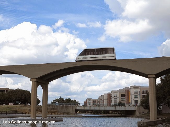
The most bizarre means of transport in the Dallas area is the Las Colinas people mover, once thought to be come a larger distributor in this also bizarre new town. The trains mostly run on demand, but not like the automatic people mover in Morgantown, but manually operated! So at least two drivers are always on stand-by until they receive a call to pick up someone in one of the four stations. Each of the two lines actually operates on its own track back and forth. Two stations are somewhat hidden between or inside office blocks, another is connected to the DART station and the fourth to a parking garage. Taking pictures can be tough if trains pass very irregularly on demand. The last driver who brought me back to the DART station was, however, very nice and waited for a few minutes until I got down on the lawn to take a picture of his cabin coming out of the station again – unfortunately by the time I got there to take my pictures, clouds had again covered the sun... Anyway, thanks for the nice gesture.

Next stop: Houston

LINKS


DART at UrbanRail.Net


Sunday, 28 September 2014

ST. LOUIS MetroLink


The third stop on my 2014 U.S. tour brought me to St. Louis, where I had already been on my very first U.S. trip back in 1995, but at that time I think I only took MetroLink once or twice from the Delmar area into the city and back again.
     The first thing that stroke me yesterday on my first trip from the airport towards downtown was that all stations have a vigilant, which I interpreted as a bad sign after having seen no or hardly any in Chicago or Minneapolis/St. Paul. And as I would find out later, these vigilants are primarily visible on the northern leg, although many of them are young girls who rather play with their mobile devices than actually watch the station. Anyway, not a setting too inviting to take many pictures.
     With a one and a half hour delay to arrive in St. Louis (I think it was due to major problems in the Chicago air space), I did not have much time yesterday to explore the system, so my main day was today, Saturday Sept 27, when trains only run every 20 minutes on each line, so waiting times can be rather long on outer legs. Given that they only operate 2-car sets, the headways should really be reduced especially on the Airport Line which gets pretty crowded up to North Hanley where many people transfer to buses (I resume they are going to northern suburbs like the now world-famous Ferguson).
The second important impression was that this system has a very German feel about it. If you close your eyes and hear the doors shut, with this cracking sound of their folding doors you might think that this is an old train in Frankfurt or Düsseldorf. Also these door-opening buttons were once typical for many German trams. Of course, the high-level platforms give an absolute Stadtbahn feeling, too. In fact, those cars are based on the type B Stadtbahn car developed by Duewag, which was later integrated into Siemens. At the front, next to the driver's cab, they have an additional door like that in Pittsburgh, with steps, but I think it is only used for staff stops at the depots. The cars, however, are a bit aging and don't have modern equipment like station indicators, instead the drivers make all announcements personally, in fact, they almost talk continuously giving all sorts of announcements like next stop and where this train goes, but mostly instructions about what to do and what not. As they do this continuously it gets a bit monotonous and hard to understand.
In the stations there are no properly working indicators, either, not even the automatic announcements are ideal. Even at the junction at Forest Park, the announcement would just say 'A westbound train is arriving in 30 seconds', instead of clearly indicating where this train is actually going. So passengers have to check the front of the train to know if it's theirs. Mostly the driver would then repeat the train's destination so people can jump off if they are on the wrong line. Apparently the network is not properly equipped with a system that identifies trains and thus enables proper information on platform panels. Maybe they wait until they get new trains to modernise this system.

Like on the train front, also at station accesses a huge (M) logo is visible on a pole which also displays the name of the station, so St. Louis boasts one of a few such systems in the U.S. to use a proper logo, something I always welcome
Of all American light rail systems, St. Louis' MetroLink is among the most metro-like when it comes to right-of-way. Long sections are grade-separated, and the newer Blue Line branch to Shrewsbury is almost completely a real metro line. At the existing level crossings, however, drivers are obliged to blow the horn twice, which I find really exaggerated, especially when they can clearly see that the barriers are down and there is no car or person anywhere nearby. For people living nearby any horn not blown would increase the quality of life!


The stations, especially after recently having seen those in Minneapolis/St. Paul, are rather basic, although all have some sort of shelter, but again they are similar to many Stadtbahn stations in Germany, which in most cases are not too sophisticated either. Two of them, Stadium and Forsyth, could also be in Stuttgart, where many such stops are located next to an adjoining tunnel. 


The older underground stations in the city centre are rather dark, with a slightly vaulted concrete ceiling which is illuminated indirectly. The staircases leading to the side platforms on level -1 are quite wide and offset from the platforms. 


The two newer underground stations on the Shrewsbury line are much larger, though not much brighter. What was very disappointing at the University City-Big Bend station (I did not get off at Skinker) were the access stairs and the mezzanine which feel like an unfinished concrete staircase leading down to a cheaply built underground car park, a shame really, because the station hall as such is quite impressive with its massive arches that support the vault.
Accesses seem to be a weak point in other stations, too, most notably at Brentwood where they forgot to build simple stairs in addition to long ramps, or at Forest Park, where only narrow stairs lead to the also narrow platform, although there are two lifts from platform to street level, too. At the airport, the terminus is reasonably close to the check-in area (compared to Chicago O'Hare and Midway and also Minneapolis' both terminals!), but at Terminal 2 passengers have to walk through or over a car park, although the walking distance is not too bad. St. Louis' Gateway railway station is connected to MetroLink's Civic Center station. Interestingly, surface stations in St. Louis also have heating devices – does it get that cold here?
     The Red Line now has a stately length of 61 km! But the question arises if this was really necessary. Apparently, an old railway right-of-way was available for most of its length, but the southeastern most section to College and eventually Shiloh-Scott was built through open countryside. Today was Saturday, so I probably didn't see its real ridership, but I wonder if it gets enough passengers during the week to justify a double-track line through the countryside when many other parts of the proper conurbation don't have any comparable type of service but have to cope with buses instead? Many stations, especially on this branch, are only surrounded by big car parks, whereas trains run through built-up areas without stopping. I would at least suggest an additional station at Belleville South.


A weak point of the otherwise rather fast service is that it avoids large parts of the city centre. I suppose, ideally, the line should have run further north along Washington Avenue or Olive Street to serve important parts of Midtown. Grand station covers parts of that area, but its location under an elevated freeway does certainly not make it an attractive alternative. Hopefully the future Delmar Loop Trolley may one day be extended along this corridor to provide a more local service than MetroLink.
     St. Louis' fare collection system also has a very German feel to it. No fancy smartcards exclusively (there are card readers), instead, day passes are issued as simple paper tickets you show to the bus driver or to ticket inspectors on trains, but I didn't see any. For tickets bought in advance there are German-style validating machines.

Next stop: Dallas

LINKS


MetroLink at UrbanRail.Net