This is a follow-up to my report from 2013 when I last visited Copenhagen. This time I came to join the
celebrations for the opening of the Cityringen, or metro line M3,
which happened on 29 September 2019, luckily without any last-minute
delay as had occured in Aarhus two years ago.

Osterport station - trains largely identical to M1/M2 trains
As a metro enthusiast, I was quite
excited about this inauguration as with its 15.5 km and 17 stations,
the ring line can be considered a major metro project for European
standards, and something like this doesn't happen too often nowadays
(besides some extensions in Moscow, the last was Barcelona's
L9-South with 20 km in 2016 and probably next will be Thessaloniki,
which is likely to become the continent's last new metro at all, and
new tangential lines in Paris).
The construction of the Cityringen went
quite smoothly as it seems, without major problems or delays and
within a reasonable time frame of some 6-7 years, when virtually the
entire inner city had to suffer from the construction sites, of
course. These were limited to station areas as all the tunnels were
excavated as single-track tubes. They often run beneath built-up
areas and thus the line would be difficult to follow on the surface
unless you are very familiar with the city. Talking about tube
construction, as with the "old" lines, the alignment is
very good and trains run at a good speed and take all curves very
smoothly. At times they shake a bit, but to an acceptable degree.
Accelerating and braking is also quite prefectly programmed, so no
complaints on that side from my part.
Gammel Strand station - Cityringen has just opened (29 Sept 2019)
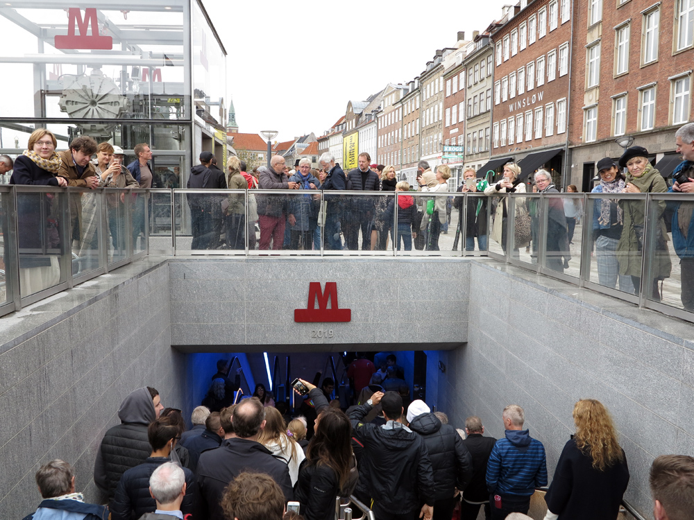
With a friend from the U.S. who
happened to be in town we managed to get down into Gammel Strand
station with the first crowd at 16:00 on Sunday, when the skies had
cleared a bit after heavy rainfall had delayed the speeches at
Radhuspladsen (including the Queen of Denmark!). We were surprised
how well Metro managed the crowds, so trains ran at an acceptable
load, though the windows got steamy soon so you could hardly see
anything out the front or rear windows. We got off at a few stations,
but didn't venture to go outside because we saw that they kept people
from entering to avoid overcrowding, but I think in the end all got
their chance to take a first ride (by the way, all metro and S-tog
lines were free to use on that day!). Later we met up with a local
expert and continued our first-day explorations, and surprisingly,
all went smoothly, I didn't observe any disruptions or major delays
typical for such occasions.
The stations basically follow the
design of the old lines, but with some differences. But I have to
admit that I was a bit disappointed when I saw the first stations as
I had expected more colour, but in the end the use of coloured panels
instead of the old concrete slabs is limited. There are several red
stations, denoting interchange with S-tog services, one in green
(Frederiksberg Allé) and a few with bricks rather than panels, but
many have colourless plastic panels which are quite similar to the
old stations:

Enghave Plads station - pleasant brick cladding

Frederiksberg Allé station - the only "green" station

Norrebros Runndel station

Norrebro station - all S-tog interchanges are red

Skjolds Plads station - similar to M1/M2 stations

Vibenshus Runddel station - decent colour, but hardly perceivable from platform level

Poul Henningsens Plads station - grey but with different pattern

Osterport station - busy S-tog interchange
Otherwise the station boxes are identical, with two
flights of double escalators up and down - but unfortunately both up
escalators still start at the same end position of each platform
instead of having one at either end. I also found that the direction
of the escalators is not well signed, especially on mezzanine level
you basically have to look at the moving steps to see if they go up
and down as there are no signs saying "to trains" or "ai
treni" above the down escalators. Regular users will certainly
get familiar and know that down is normally the escalator further
away from the entrance. The issue I criticised in 2013 about the lack
of escalators from the mezzanine to the surface has only been solved
in a few places, notably in the richer municipality of Frederiksberg,
where the entrances have therefore also been covered (in the case of
Frederiksberg Allé built over with a new building) - by the way, the
choice of the names Frederiksberg and Frederiksberg Allé for two
adjacent stations is certainly not very ideal!

Frederiksberg station - covered escalators up to the surface
My major criticism is for the
wayfinding system. Showing directions on circular metro lines is
always a challenge, but there have been good solutions, notably on
Madrid's L6. On Cityringen it is badly implemented, although the
electronic next-train indicators handle it quite well by showing "via
Frederiksberg" or "via Osterport" or whatever is the
next major interchange in either direction. This is complemented by a
running line of all stations served from that side of the platform:


Large screens show directions
There are accoustic announcements, in
Danish and English, saying that the next train from "Spor/track
1" or "2" goes via so and so, but the track number is
hardly visible, certainly not when you come down the escalator, and
then you still have to search for it. What is completely missing, and
not just on Cityringen but also on the old lines, is a partial strip
map for each side of the platform. The funny thing is that this is a
global convention from China to the USA, virtually on all metros of
the world, but not in Copenhagen. So when you come down the
escalators, there needs to be a strip map showing which stations can
be reached most rapidly from the right side, and which stations from
the left side. On most metro systems the stations of the line not
served from that platform are shown in grey.

Strip maps as displayed at end of platform, without indicating which side of the platform
There is a strip map even
in Copenhagen, but it shows the entire line and not as a circle, but
as a straight line, and does not hint to the respective side of the
platform. This can easily be retrofitted and I hope it will be done
soon. In fact those partial strip maps should also be added to the
respective platform screen doors so people can be sure they are
waiting at the correct side. Apart from that, all stations have a
nice metro map with the Cityringen shown as a proper circle and
future-proofed with M4, saying that the northern branch to Orientkaj
is about to open in 2020:

Talking about maps and information,
only at certain stations of the metro system, a "Welcome to
Copenhagen" brochure is available and only in English and only about the metro, otherwise
I'm still missing a proper customer service centre, I have not seen
any although now many staff were still around on M3 to help
passengers. Luckily I grabbed a few small metro maps on opening day,
as later during normal service I didn't see them anywhere.

Strip map inside trains (with line M3 "starting" at Trianglen), not future-proof for southern M4 branch
To improve orientation for passengers on the train, additional station name signs would be useful on the otherwise empty inner walls, so passengers can see through the train window easily where they are as the signs on the platform are hardly visible from the train, most of the obstructed by the escalators. This could easily be done by adding simple stickers as the area is quite vandalism-safe.
As said before, the stations are largely identical to the older ones, but now have two lifts to guarantee their availability. Some stations have secondary entrances, but only via a bicycle storage room, even the centrally located Radhuspladsen station! These bike rooms are colourful and are mostly painted in a strong orange.
As said before, the stations are largely identical to the older ones, but now have two lifts to guarantee their availability. Some stations have secondary entrances, but only via a bicycle storage room, even the centrally located Radhuspladsen station! These bike rooms are colourful and are mostly painted in a strong orange.

Two lifts at each station, and most with skylights

Lovely logo, here at Nuuks Plads
A much brighter logo sits now next to
all stations, which has also been implemented at some older stations.
The only station with a significantly different layout is
Marmorkirken where the platforms are on different levels on top of
each other due to the limited space available:

Marmorkirken - bi-level station
There are two lifts,
one at either end of the platforms, plus numerous sets of escalators,
two in each direction, and connecting 4 levels, so that adds up to at
least 16 escalators if I have counted correctly.
The interchanges with other lines only
deserve an "ok". Cityringen crosses the old lines twice: at
Frederiksberg this is quite ok, you walk up one level from M1/M2 and
walk around the corner and down a few levels to M3 - what's weird
here is that all escalators, up and down, point away from you instead
of resulting in a logical flow from one line to the other. I doubt
that the southern exit at that station is more important than the
interchange.
At Kongens Nytorv the situation is not
ideal either but "ok". Unfortunately, it was a historic
mistake to not make this station future-proof as an interchange from
the start. The old station is pretty deep, so the new station had to
be placed almost at sub-surface level, but of course, the tube
tunnels require a certain depth. So from the old line you also have
to come up all the way to the mezzanine (two long escalators), then
walk a bit longer than at Frederiksberg through a vast mezzanine and
then down one level (for which three sets of escalators have been
installed).

Kongens Nytorv - mezzanine and transfer corridor

Kongens Nytorv - wider platform than usual
There are no direct lifts from the surface to the
Cityringen platform, you need to change lifts at mezzanine level. But
what I found more disappointing at the most central station is the
lack of other entrances and the bad layout of the only one existing.
When I arrived at Kongens Nytorv on foot from Marmorkirken via Store
Kongensgade, I was expecting an entrance at that corner of this large
square, but none in sight, so you have to cross a major road to get
to the entrance and then walk back to the platform. Once down on the
platform I realised that there was actually a rear exit (the sign
only said "Exit" - funnily they only use the English word
on this line and not "Udgang"), but no indication to where
this exit leads.

Kongens Nytorv - corridor leading to secondary exit
So I walked out that way, up one level where it
suddenly turned direction and after some 100m of granite-clad tunnel,
it leads to an exit next to the opera house, well, more or less
across the street from the main entrance! So many questions starting
with "why" came to my mind! Why is there no proper second
mezzanine on the north side of the Cityringen station with an exit
towards Store Kongensgade and another one towards Nyhavn, the busy
restaurant area, and instead a misleading exit towards
Tordenskjoldsgade - misleading because if you enter the station
complex here and actually want to take an M1/M2 train, it will take
you on a long detour. This entrance should lead into the large
mezzanine directly! This is really weird as Kongens Nytorv has been a
contruction site for the last 25 years and now it is badly done! At
least the fixed stairs from the mezzanine to the surface have been
completely rebuilt and are now much less steep than they used to be -
so maybe my criticism has helped...
As for interchanges between M1/M2 and
M3, these options are not announced accoustically like "Change
here for lines M1 and M2!", neither are there any announcements
like "Change here for the S-tog/S-train".

Norrebro - open-air interchange with elevated S-tog
At Norrebro the interchange between
metro and S-Tog will be as good as is possible in that situation,
with two sets of escalators as well as lifts being added to the
elevated S-tog side platforms, and here also escalators have been
installed between the surface and the mezzanine in the metro station.
As with the other S-tog/metro interchanges, the facility has not been
finished yet.
At Osterport, a connecting pedestrian
tunnel is still under construcion, but in the meantime, metro
passengers have to use a set of temporary stairs to come to the
surface and walk around the construction site to get to the railway
station. To comfort them, metro staff are handing out vouchers for
free coffee at 7-Eleven... Just as we will see at the Central
Station, the lifts are located at the "wrong" end of the
station for people changing to S-tog or other trains services.

Kobenhavn H - metro entrance at rear side of railway station, with tiny logo

Kobenhavn H - on the left, future interchange tunnel to S-tog and other trains
The location of the metro station at
Kobenhavn H is far from ideal. It is certainly at the back side of
the station, and maybe not the best side either. From a logical point
of view, it should really have been located on the eastern side where
there is a main entrance to the railway station, possibly with an
access directly within the station concourse as any world traveller
would it expect to be. To serve the area west of the station,
possibly an additional station would have been needed. But
complaining about this now doesn't help us anyway. When the later
planned direct transfer tunnel is completed, interchange between
metro and trains will be quite ok, though through a very narrow
tunnel. Until then you have to leave the metro station and hope that
many people head for the railway station, because from where you
surface you don't see any sign at all where the railway station is or
where to access it. The rear entrance is very small for a major
railway station and has no sign whatsoever, just the usual crowd of
people thrown out of the station by the police hanging around
there... What's also surprising at this location is the tiny logo
indicating the metro station, only denoting secondary bicycle
entrances at other stations. And again, the lifts are at the other
end of the station, so for passengers coming to the surface with
their luggage using the lifts, the orientation will even be less
easy.
All in all, Copenhagen has certainly
grown up with the opening of this line. I still remember that
Copenhagen was something like the largest non-metro city in Western
Europe when I started in the mid-1990s, and now it is very well
covered by a swift system. And it seems to be very popular among the
local population, forgotten are the initial troubles and it is
perceived as a very reliable system. Maybe even victim of its own
success, the Metro company now has increased fares, i.e. to use the
metro you have to pay a surcharge on certain tickets, and monthly
pass holders have to decide whether the metro is included or not.
This is certainly a wrong step as Copenhagen has always had good fare
integration and breaking this is a step backwards. But maybe the
Metro company actually wants to dissuade people from using their
trains to avoid overcrowding as trains do get pretty full during rush
hour. The next logical step would therefore be to increase capacity,
this could maybe be done by adding a fourth car, but possibly some
stations wouldn't be able to handle the crowds anyway. Notably
Kongens Nytorv which has always been a busy station as it serves the
Old Town, and now as a transfer station it will even have to handle
more people. Now a train arrives about every 90 to 120 seconds during
peak hours in either direction, not really enough time to empty the
platform before the next train discharges its passengers. Norreport
station may be relieved a bit as many passengers will now change to
Cityringen instead of the S-tog.


Carlsberg S-tog station replaced Enghave station in 2016
While the metro is now the popular
means of transport in Copenhagen, the S-tog is losing terrain as it
is aging. Many trains carry graffiti and also stations are not always
in good shape. The system is currently being upgraded with CBTC which
may ultimately lead to driverless operation, which would be a first
on a suburban rail system derived from a mainline railway (like the
Berlin S-Bahn, the Copenhagen S-tog is completely separate from the
rest of the Danish rail system and has a different voltage). The
super-wide trains are still fun to ride, but the bundled route along
the central corridor is a bottleneck. So the CBTC system is supposed
to allow a more stable timetable. At Copenhagen Central Station, the
S-tog has two tracks in each direction, but at the other stations
just one. Norreport is a special problem, as it is supposed to be the
busiest station in Denmark, but with just two S-tog and two regional
train platforms. It is also the ugliest and most neglected station,
I'm afraid, and for such a busy station, there is no customer service
centre anywhere, although new buildings were added at surface level.
At the Central Station, DSB maintains a rather small traditional
ticket office, and as for some reason I couldn't buy my return ticket
online (DB said it was too late) I had to queue there to get my
ticket to Berlin - I felt like in a Renfe station back in the
1980s... As the S-tog is run by DSB, I imagine that they also handle
questions about the S-tog. There is someone at the door who in most
cases sends you to the self-service ticket machines, though. These
are easy to use and also sell City Pass tickets, the day passes for
all means of transport, available as a "small" or "large"
City Pass, not a very intuitive distinction. The "small"
one is the real City Pass as it covers the city as such plus the
airport, while the "large" one should really be called
"Region Pass" instead, or "City+Region Pass" or
so. Both passes are available for from 24 hours to up to 120 hours!
As for my complaint about a
non-existing face to the integrated transport system, there is one
now, though only to a limited extent! It is called DOT which stands
for Din Offentlige Transport (Your Public Transport). They have a
website with some useful info and their logo is everywhere on all
vehicles, also metro and S-tog trains, but it's not really a
transport authority nor does it have an information office.
LINKS
Copenhagen Metro (Official Website)
