Thursday, 30 April 2015

VALENCIA & ALICANTE Update

I already posted my impressions on Valencia and Alicante back in early 2013, so this blog is just to update a few things I have observed during my recent visit at the end of April 2015.

In Valencia, I checked the latest extension, the newly introduced L9 from Rosas to Riba-roja de Túria. The line surfaces shortly after diverging from the shared airport line (L3/5) and after the first stop La Cova becomes single-track. The two intermediate stations also have passing loops, but apparently only the northern track is used at all times, because the southern (theoretically the inbound) platform doesn't even have any signs or ticket machines, etc. The terminus at Riba-roja is also double track (two stub tracks) but here also only the northern side is used. This sort of temporary station is really the weak point of the entire extension, as it is not at the location of the former Cercanías station (the metro basically replaced an old railway line), but almost a 15-minute walk from the town centre. In fact, they built a paved path along the old rail formation as walking along the main road would require a hill down and up again. I understand that the initial idea was to put the line underground through this town and continue to Vilamarxant, but then the cheaper version was finished. The service runs only every 30 minutes, so more an S-Bahn than a metro, and although the train I took was fairly occupied, the intermediate stations were hardly used. La Presa actually has a large park&ride facility, but only 3 cars were parked there that day! The train was a bit slow on the out-of-town section, but otherwise the ride was quite o.k.


Interesting to see when I read my earlier blog entry that in some cases they seem to have listened to what I had criticised... With the opening of L9, the entire line numbering system was changed to disentangle the network a bit, a looks much cleaner now with a different number for each routing, and the old line 2 is back on the map! They also added accoustic annoucements to warn passengers about the train's destination before a junction (for example "Este tren finaliza su trayecto en Marítim-Serreria"), also line numbers are now shown on train fronts and on next-train indicators! Apparently as I was told, there were lots of errors and mistakes in signage when the new numbers were introduced, some so severe from what I saw on photos that hopefully the responsible person was sacked, but good news is that within quite a short period they seem to have it all fixed.


The rest of the afternoon I spent revisiting the long interurban southern L1 to Villanueva de Castellón I had first travelled on in 2000. As I missed one train at Àngel Guimerà I had to spend 40 minutes before the next train would go out there, so I had time to take a few pictures at Sant Isidre where they had built a new railway station for some regional lines that are currently unable to reach Valencia Nord (they will soon return there but running via Fuente San Luís and backing up into Valencia Nord!). Anyway, eventually I got on my L1 train, quite full, so thought they could really run more often at least to Picassent. I was using a stored-value ticket and as Riba-roja was the last point where I had checked in, and that was already a while ago, I was worried whether the ticket inspectors who came on at Torrent would accept my ticket, but they did. I got off at L'Alcúdia to see at least one of these villages the line serves, but that was just a sleepy almost empty place, so I had to wait another 40 minutes to carry on. While other stations have those Check-in/Check-out machines on all platforms, here I actually had to search for one, placed inside the station building only! When I eventually got to Villanueva, I couldn't bother to hang around there and quickly checked out and in again to return on the same train. I could have taken the risk and not check my ticket, but although that is in zone D, fares are pretty low in Valencia anyway. I was positively surprised that the track on that line, apparently renovated not too long ago as some still-standing signs said, was quite good and the train actually ran faster than on the new L9, but unfortunately the seats in these new trains are simply too hard and uncomfortable, especially on such long journeys! While most stations have standard updated signs, two stops seem to have missed this round of modernisation, Benimodo, which shows signs dating from 1988, and Col.legi El Vedat, which has no signs at all, and is only used by young students from a nearby school (unfortunately they just left for home when I was travelling past...).

In Alicante I basically checked out the new line 2 to Sant Vicent del Raspeig, which had been completed years ago but only opened several months after my previous visit. This line is a typical modern tramway, all on reserved right-of-way through a very urban environment, but it is pretty slow and only runs every 15 minutes. So my major complaint about the Alicante system are the long headways, which at 30 minutes are even worse on L3 and L4 (but there restricted by a single-track section). But L2 could really run more often as it does become quite busy. I was surprised to see one tram operating as a 2-car unit, but that doesn't help much, if such a compound only appears every now and then (I think the students' travelling habits are not so predictable!). The shared tunnel section does not seem to be close to capacity yet.


Another negative issue in Alicante is the lack of an easy-to-use day ticket, especially being a tourist destination! So, as I didn't really need a 10-ride ticket, I had to buy a single ticket (1.45€) before/upon each boarding. I wonder whether this is the only city in Spain with ticket machines inside the trams? And it seems they have a problem with fare evasion, because at one point a brigade of at least 10 ticket inspectors invaded the tram, supported by some security people!


Later I had a look whether the old 4L branch from Sangueta to Puerta del Mar was still in place or disconnected or even dismantled, but it is still there, even the tram signals were still working, just the huge train indicator at Puerta del Mar looked rather abandoned. 

Read my previous blog posts on Valencia & Alicante! 


Monday, 27 April 2015

PALMA (Mallorca) Metro


This has been my second visit to Palma, the first was in January 2009, not too long after the Metro had opened in 2007. I have come back now to take a few more pictures for my forthcoming "Metro & Tram Atlas Spain" due to be released later this year.


Palma is actually a very nice city, but the Metro is close to useless for the city, in fact it is probably the most useless metro system in Europe and possibly in the world. It is only good to transport students from the city centre to the university campus located some 7 km outside of town. Although this would normally be enough reason for such a rail line it seems that Palma's students prefer other options for some reasons. Frequencies are rather those of typical S-Bahn systems, with a train every 15 minutes during busier times, and only every 30 minutes during other times, with no service at all on Saturday afternoon and Sundays. Like any university campus, this one is spread out but the metro station is not located somewhere in the middle but on the fringe of the campus requiring long walks from some areas. So, you could call it the Metro where your seat is guaranteed.

I'm now talking about the original metro line, which is now officially M1. This metro line was also the most unexpected to be built and probably the fastest to be put into service (although it had to be closed for several months shortly after opening because one of the underground stations was flooded and apparently this possibility had not been taken into account during the hurried planning. About 80% of the line is underground, although it doesn't go through any densely built-up areas, instead it only runs through an industrial estate where the visual impact of some sort of surface line wouldn't have caused any problems. Also the university terminus is underground, although it lies on the edge of the campus and a surface station wouldn't have disturbed anyone. So, all in all, a lot of money was wasted for something that was not really a necessity. Everyone knows that I'm a devoted metro enthusiast, but for Palma, I think, some sort of light rail within a larger context would have been a much better choice.


The line ends at Pl. Espanya, which is the city's major interchange point. But as there is no proper fare integration, of course, noone would use the metro for just 1-2 stops to change to a bus at Pl. Espanya paying another full fare, and there are plenty of buses available along the same route. So, finding some kind of deal for a common fare system is urgently required. Talking about fares, like in most Spanish cities, these are relatively low, but in the case of Palma rather unpractical, as there is no multiple-ride ticket or day pass, so you need to buy a single ticket each time you want to enter the system, as stored-value cards are only available for people living in Mallorca! So each time you enter the system, you have to get a paper ticket for 1.60€, and quite uncommonly, these tickets carry a QR code you have to hold against a reader to open the doors. But at least in 50% of all my entries, I had problems with these readers and had to try various times. As you have to do the same procedure on exiting due to additional fare zones on the regional lines, this would normally lead to some overcrowding at the exit gates. So I don't really understand why they chose such a system not used anywhere else I have been to, it's more what you'll find at theme parks or so. Probably most riders are regular riders who use a smartcard instead.


Line M1 is not badly built, though. The short 2-car trains offer a smooth ride, track seems to be properly laid (it certainly helped that the metro line is actually part of a larger railway system), and even the stations are rather pleasant. The city terminus at Pl. Espanya was generously/excessively laid out with 10! terminal tracks (FGC handles much denser traffic with only five tracks at its Pl. Catalunya terminus in Barcelona!), and although the platforms lie deep enough on level -2, the location of the escalators would not allow an easy extension into the city centre proper, but such far-sighted issues were probably irrelevant during the speedy planning. Another flaw of this huge terminus is the lack of an underground walkway to the old town area, instead people have to cross a 6-8 lane main road on the surface. This underground hub also includes a bus terminal for regional buses, but apparently, some of these have to take a long detour to actually get in there... Those buses are part of the TIB system which also includes the regional rail lines to Manacor and Sa Pobla via Inca. That the ever-changing Balearic governments are not too good at planning can also be seen in the frustrated project for a "tram-train" from Manacor to Artà in the east of the island. An old railway alignment was prepared for this and even some partly low-floor trams were purchased from Vossloh, but the next government simply cancelled the advanced project and now they have six Citylink trams noone wants and needs. So to give them some reason to be, they operate three morning express trains between Inca and Palma, for which a low-floor platform extension had to be built into the tunnel at Pl. Espanya.

In 2013, line M2 was invented, but this did not require any construction, but was rather a rebranding and service modification for local services now running between Palma and Marratxí serving some villages that have grown to become suburbs. Initially started with new EMUs acquired for the regional services, M2 is now served by metro rolling stock not needed on line M1. As a result, many of the new EMUs are waiting in the depot, as electrification of the outer stretches of the regional lines has been delayed. Compared to the acceptable stations on line M1, those on M2 are simple, if not primitive stops, and the route reminded me a bit of the outer sections of the Valencia Metro, as at some stops you can see an old station building at a lower level and a high platform built next to it. Serving proper villages, the line has some decent ridership throughout the day. At Marratxí, ideally line M2 should terminate on a track between the continuing tracks served by regional trains, but instead they use a bay track on the northern side sharing an island platform with inbound regional trains, which offer convenient connections, with M2 leaving shortly after the regional trains come through. But to change trains in the outbound direction, passengers have to change platforms via an underpass and waiting times for connecting trains are longer. It would probably be advisable to make M2 trains switch to the proper metro tracks as they enter the tunnel, so M1 and M2 would share the same platforms at Son Costa/Son Fortesa and J. Verdaguer and thus offer an improved service at these stations, whereas now it is not clearly signposted which platform will have the next train towards Pl. Espanya.
Next-train indicators are located on the platforms, but many of them did not work. And when they work, they show the next five trains, but who cares about further trains, generally the next two should be enough. In fact, even the second train is irrelevant in Palma, although this is sometimes useful on busy metros where one might skip an overcrowding train knowing the next is following shortly. But as said before, overcrowding is certainly not a problem in Palma...


Besides the basic M2 stations, the image of the Metro is also suffering from many of the trains covered with graffiti. Inside they usually looked o.k. although some litter was lying around. The stations are generally tidy and graffiti-free. Illumination of the underground stations is o.k. but could be slightly brighter. From the train, all stations look rather dim due to the dark windows.

So what could be done to give this metro more sense? Probably rebuilding the entire M1 into a low-floor light rail system and connect it to a city-wide tram system would be the best choice. They could ask their colleagues in Cologne who have enough experience in changing high platforms to low platforms with destroying the platforms, simply by raising the ballast trackbed in the stations. The size and layout of Palma are quite ideal for a good tram system, with several branches radiating from a circular Avenidas route, plus an old town route now served by many bus lines. But a first step really has to be proper fare integration with easy-to-use day tickets for occasional riders and tourists.


Tranvía de Sóller

Visiting Palma, an urban rail enthusiast has to visit the heritage tram in Sóller, too, no doubt. Although the 4 km line is used also by some locals, it is primarily a tourist attraction, and a very popular one. Even in late April many trains (they are made of up to four cars!) are completely full, and at 5.50€ for a single ride, this must be quite a good business. But riding old trams with wooden benches on worn-out track has never been my favourite pastime, but I did, of course go on a full round trip and took lots of photos, too.

LINKS


Palma Metro at UrbanRail.Net


Sunday, 8 February 2015

TENERIFE Tranvía

During my recent winter escape holiday on the island of Tenerife at the end of January 2015 I had the chance to explore its small tram system, el Tranvía de Tenerife, and thus do the necessary research for my forthcoming 'Metro & Tram Atlas Spain' due to be released later this year.


All in all, the modest 2-line tram system has a very French feel to it, not just because of the Alstom Citadis trams used with their 5-colour scheme (I prefer the blue end to the green one), but especially for the alignment chosen. The routes are on reserved right-of-way throughout, and pretty well integrated into the urban environment which with the arrival of the tram certainly experienced an improvement. I was surprised that the decision-makers at the time were strong enough to really reduce space for cars, be it by taking away car lanes or parking spaces, in favour of a reserved route even through the older parts of town where hardly good alternatives for car traffic exist. So, all in all, travelling on the tram is quite fluid, and traffic lights seem well-adjusted so that there are no annoying waiting periods. There are, however, numerous roundabouts which the trams pass through the middle, and having done the entire route also twice driving in a car, I'm not convinced about this solution. When trams pass through, cars actually, or at least, get a red light, but this is somehow contradictory to a roundabout philosophy (I observed, however, that in Tenerife, many roundabouts are illogical, and that suddenly you get a red light to allow pedestrians to cross or even worse, that suddenly you get a 'give way' sign in the roundabout!). Anyway, I would think that these roundabouts are too often the cause of accidents between trams and cars, although I don't know what Tenerife's record is and I did not experience any 'almost hit' situation, in fact, I observed that the locals drive rather cautiously and slowly.

Many track sections are covered by lawn, even on the central section between La Paz and Weyler, which is unusual, as in many other cities such sections would rather be paved to allow emergency vehicles to use the reservation. Between Weyler and Fundación, the tracks are embedded in the roadway, although very limited access is allowed for vehicles. I think that grooved rail was used on all sections when actually Vignol tracks are normally more pleasant to ride on and some sections would certainly have allowed that.


What is pretty fascinating about Tenerife's first line is that on its 12.5 km route it rises from sea level in the capital Santa Cruz up to some 550 m in La Laguna, the old capital and university city of the isle. Thus from some points you get an nice view of the harbour and Santa Cruz. This difference in altitude also explains the somewhat detour the tram takes between the two termini. In Santa Cruz, the two stops Weyler and Teatro Guimerá serve the city centre proper, whereas the trams continue down to the Intercambiador, which is a huge bus station. Unfortunately, the tram is not directly integrated into the complex, so transferring passengers need to walk a bit between buses and trams. Before the big economic crisis, a train line was planned south to Tenerife Sur airport and Los Cristianos, I guess the terminus for that line would also be part of this hub.

So while L1 links the two centres of what is an agglomeration with some 400,000 inhabitants, the layout of the 3.5 km L2 is not really convincing. L1 runs about every 5 minutes on weekdays, whereas L2 has a tram only every 10 minutes or so. It really feels like a second-class annex, requiring a transfer to L1 for almost everybody. And these transfer options are not too convenient, because they are also related to the least convincing sections of the route alignment: both junctions were put below street level – a good thing a such, because it avoids conflicts with cars at two roundabouts – but these underpasses are not well built (a bit like the flaws on Madrid's Metro Ligero): the Citadis, not too good in curves anyway, have to crawl through them at minimum speed! So passengers from the Tíncer end of this line who want to get into Santa Cruz, need to crawl through one of these underpasses twice and change trams at El Cardonal next to the tram depot. So, people who would board L2 at San Jerónimo would probably be faster walking to Taco station and get L1 there directly. And to add to the inconvenience, the two stops shared by both lines have side platforms instead of the otherwise prevalent island platforms (despite of these being the majority, an announcement is heard at these: 'parada con andén central'), so it is not surprising that L2 trams run half empty compared to the well-patronised L1 trams.


The stops all have a standard design, simple, but well done, each with two multilingual ticket machines and an information panel with a map and tram frequencies. As said before, most have island platforms, but some have side platforms. In the case of Príncipes de España, the island platform is actually part of a central Rambla (esplanade). The island platforms are generally accessible via ramps at both ends. The platform height matches exactly the tram floor. So, full accessibility has been achieved, although the steepness of some stops, notably Conservatorio, may be a challenge for wheelchair users. What I appreciate is that the name of the stop is written in big letters on flag-like panels, so they are easily identifiable even for car drivers and thus serve for orientation. The M-logo, however, is not so convincing.


With an average distance between stops of more than 600 m on L1, I think there should be a couple of more stops to give better coverage, notably between Puente Zurita and Cruz del Señor (830 m) in a densely built-up area with a significant gradient, an additional stop inside the big roundabout halfway between these two stops is recommendable. And Las Mantecas stop should really be relocated some 250 m further south just after the ramp to give service to existing housing estates, whereas now it is in the middle of nowhere on a steep gradient. If the area further up towards Campus Guajara gets developed, an additional stop could be added. Similarly, there could be an additional stop between San Jerónimo and the terminus Tíncer (850 m) as the latter is up on a steep hill and noone wants to climb up the hill to catch a tram.


The 26 (or so) Citadis trams are standard Citadis vehicles, with an acceptable interior distribution (especially enough space in the modules with doors), although the single-leaf door at the front leads to some congestion especially as everybody boarding needs to validate their ticket somehow (see below). But I have never been happy with the Citadis' behaviour in curves, luckily, except those described in the underpasses, there aren't any that I would have classified as ridiculous or horrible, as the overall alignment and track layout is quite satisfying, no unnecessary turns or deviations from what is a rather straight-forward route.

There have been several proposals for extensions, notably from the La Laguna end to the northern (more domestic) airport, from Tíncer southwest to La Gallega, the only area available for urban expansion in Santa Cruz, and a second cross-city route that would connect to L1 at Intercambiador, serving the newer parts of the city before turning into the old centre, intersection with L1 at Weyler and heading northeast along Méndez Núñez street towards the north pier of the harbour. It will be interesting to see how the later route will be laid out, as the street in question, besides the Rambla, is one of only a few that actually allow some fluid car traffic, so restricting access for cars here too would be quite a brave decision. But certainly, the tram route would be useful, as it would serve the new landmark Auditorio and the Congress Center. Many areas of Santa Cruz will still be left without tram service, impossible to implement as most streets are too narrow and too steep, although a direct tram line from La Cuesta down into the Santa Cruz centre along the historic route could be feasible if desired.


Unfortunately, like so often in Spain, the positive French influence did not affect the fare system and integration with the local bus company TITSA, although there are several fare options which allow transfer between tram and buses in the metropolitan area (TITSA serves the entire island). Single fares on the tram without transfer to buses are just 1.35 EUR, and a day pass for the tram only is 4.50 EUR: although the ticket might suggest 'guagua' (Canarian Spanish for bus) + tranvía, it is only valid on the tram! So, this ticket seems to be made for tram fans only, for anybody else a multi-ride ticket (5 trips for 6 EUR) or a BonoVía (a money value card sold at 15 or 25 EUR that deducts 1.05 EUR per tram ride plus a small transfer fee if changing to a bus) is a better deal. Even the day pass needs to be validated upon each boarding (each time the machine stamps a car code on the reverse of the ticket so inspectors would see immediately if you forgot to validate it). Many of the locals, especially the younger ones, use their smartphones which they hold against a QR code posted all through the trams (Vía-Móvil system). TITSA operates urban buses with varying headways, they do have a timetable booklet, but are unwilling to produce a map it seems. When I asked why they didn't have one, the lady at the Intercambiador counter answered that there were too many lines to show on a map. I asked her how she thought that proper cities like Paris or Madrid were able to produce bus maps? Unfortunately, I have noticed repeatedly that when a company is in charge of an entire region, they neglect the service they are supposed to provide in the urban area. So, the local population would probably be better served if there was a single transport operator for trams and buses for the metropolitan area, and a different company for regional buses serving the rest of the island.

LINKS

Metropolitano de Tenerife (Tram operator)

Tenerife Tram at UrbanRail.Net


Monday, 20 October 2014

SAN JUAN Tren Urbano


Coming from Miami, Puerto Rico was my last stop on this 1-month tour through the U.S., in preparpation for my forthcoming book 'Subways & Light Rail in the U.S.A. - Vol 3:Midwest & South', due to be released in December 2014. Hot Puerto Rico was, of course, also a nice final stopover before going back to autumn temperatures in Berlin.

San Juan has a single urban rail line, referred to as 'Tren Urbano' rather than the more universal 'Metro', although it is actually a real metro. Let's start with its two major flaws – too long headways between trains and what is without doubt its most significant problem, it ends short of the city centre and therefore operates far below its potential. Otherwise my impression was quite positive.


The current line runs from Sagrado Corazón to Bayamón, but Sagrado Corazón is by no means a natural end of a metro line at all. The initial project included two underground stations further northwest, which are urgently needed to give the entire line a real reason to be. A further extension towards Old San Juan is, of course, very recommended too. Sagrado Corazón lies in a badly developed area, probably not a very nice place to wait for a bus at nighttime, especially as the bus system is the worst I have ever seen in any developed country (after all, this is part of the U.S. and people insist that the U.S. is a developed country....). Unless you already know which bus goes where, there is no real way to find out. Bus stops have a bus stop sign, but that's it, no line numbers, no timetables, no maps, so you completely rely on locals' information, and like my hotel receptionist, some of them have no idea either. Most buses are, however, new and air-conditioned, and riding them is cheap. They are operated by the British company First, and their mother company should be ashamed of the service provided over here. But it is probably not their fault, but a problem of who is actually responsible for proper passenger information? ATI (the government transit department nicely standing for 'Alternativa de Transporte Integrado' – but alternativa of what??), or is it AMA, the bus company, or First, the contracted operator? Anyway, you cannot buy day passes on buses, just at metro stations, so once you find out which bus may take you to the metro, you have to pay 75 cents for the bus, at the metro station you get a day pass for $5.00 which is also valid on buses... But watch out, the day pass doesn't let you get back into a station for a period of approx. 20 minutes, so popping out to take a picture and getting back in again to jump on the next train is impossible, so this can be very time-consuming. Although even with normal strip cards, you sometimes have to try twice as the machine doesn't read them correctly. Ticket vending machines are quite easy to handle, you can buy single fares for $1.50 or put any value on the card and the fare will be deducted on entry. Tickets also have to be swiped when leaving the station. So, all in all, the integrated fare system has only been implemented half-heartedly. I find it extremely bad that not even the big bus station in the Old Town has ticket machines or ticket windows. That there are no maps available, is no surprise. Inside the trains there are some system maps, but they are so small, it is impossible to read them. While other pathetic bus systems in the U.S. have at least some online services, AMA has no information at all, not even a classic list of bus routes, and no trip planner, of course. So this is certainly not first-world standard.


Let's get back to the Tren Urbano – except for the bad headways (a train every 15 minutes) and the city-side end in the middle of nowhere, it is actually quite good. The stations are all big structures, most of them elevated, two underground and some at grade, all very spacious and equipped with all sorts of lifts, escalators and stairs. Most stations are completely covered, in some part of the platform is uncovered, which is not so much a problem now as only 4- instead of 6-car trains are in service and they normally stop at the covered section. Unfortunately all stations appear rather grey, not even the purple line colour adds a little touch as it is too dark. At most stations, there is some work of art somewhere, but at platform level this is only well-visible at Jardines. Some have sculptures outside the station, or murals a decorated ceilings in the entrance areas:


Generally, all stations have pleasant entrances, mostly below the viaduct, and for the stations in a cutting like Martínez Nadal, Centro Médico or Jardines, with a free-standing surface building. 


In the case of Río Piedras, the two entrances are integrated into buildings which apparently replaced buildings previously demolished to allow for the construction of the access shafts to the system's only station built by mining techniques:


The other underground station, at Universidad, however, was built by cut-and-cover, it features one 'headhouse' and one simple entrance. Only a few stations, like Martínez Nadal or Bayamón, have shops like Subway, whereas most shop facilities for example at Sagrado Corazón remain empty and unused (adding to the deserted atmosphere at the terminus). What is missing in most stations are a larger number of benches, and as many young people take the metro, you see lots of people sitting on the floor. I guess with a 15-minute headway more benches should be provided. All stations are staffed with a security person sitting next to the entrance at most times. Only busier stations have two exits, but an emergency exit which looks almost like a full-size exit is visible in some. At Jardines, a proper eastern exit is planned, but has not been finished as the development on that side of the line has not progressed as planned. Unlike most American rapid rail stations, those of the Tren Urbano are quite well integrated into their respective neighbourhoods, and distances between them are more European-style than American, with less than 1 km between them in most cases.

Again, the issue of the next-train indicators is badly solved. At one or two locations in the middle of the platform there is a running indicator saying 'The next train to Bayamón arrives in 4 minute(s)' 'El próximo tren hacia Bayamón llegará en 4 minuto(s)', which means you don't get the information when you look at the indicator, but only when the indicator happens to display it. This is one of the few announcements made in English, too. Accoustic announcements on the train are made in Spanish only. Written info is certainly given in both languages.

San Juan's metro uses a proper logo, visible on trains and also on a pole outside the stations. It is made of various colours and suggests that the 'TU' also stands for the possessive pronoun in Spanish, meaning 'your'. And what is always very welcome, the logo with an arrow is also located at many road intersections or freeway exits, so finding a station is not so difficult. So why can't the people who designed this be recruited to develop a good bus information system too?

The trains are in good condition after 10 years of service, maintenance seems to be adequate, the wheels run smoothly and the track is also properly maintained. The trains don't run too fast, though, and get a bit louder in curves, but nothing too bad. Normally 4-car trains are in service during the week, although platforms are laid out for 6 cars, and on weekends, only 2-car trains are used. The cars are wide enough and feel spacious, the seats are o.k. You can choose between forward, backward or longitudinal seating, so all options are available. I don't know about peak hours, but off-peak there is always a seat left, although the system is quite well patronised for what it is. Although most trains show a TU logo, the original colour stripes on the sides have disappeared and the trains appear an plain stainless steel, emphasizing the overall colourless appearance of the system.

So the overall impression is good, but with a sense of pity that it has not been properly finished and extended to make it a really successful story, but the foundations are laid. Let's hope for the sake of San Juan's people that they will soon get some competent politicians who are strong enough to bring a good project to a good end. As said before, the Santurce two-station extension to Minillas is a must, then the previously suggested leg to the airport and the branch to Carolina, for which tunnel stubs were built just south of Río Piedras station, should follow as well. And another 2 stations towards Old San Juan, the historic city centre, should be added, too. Unfortunately I did not get a chance to ride the AcuaExpress, a ferry service between Hato Rey metro station and Old San Juan, because it was out of service after some accident at the Hato Rey pier.


But the whole system can only be successful if finally someone organises a good complementary bus system too, many stations were laid out for this. But if commuters cannot be sure that a bus will be there at a fixed time to take them to their work or back home, they will not really be willing to switch from their beloved cars to public transport, i.e. there won't be an 'Alternativa de Transporte Integrado'.


Last stop on this tour! Return to first stop: Chicago

LINKS

Tren Urbano (Official Website)

Tren Urbano at UrbanRail.Net


Thursday, 16 October 2014

MIAMI Metrorail/Metromover


Sitting at Miami Airport waiting for my flight to San Juan in Puerto Rico, I'm looking back on my 1-day exploration of the Miami urban rail system, which consists of the Metromover and Metrorail, the latter with just one line basically, so it is easy to do in just one day.

Officially, since the Airport branch opened, there are two colour-coded Metrorail lines, and that's also implemented, there is a colour board in the front window, which also says 'Orange Line' or 'Green Line' in letters for those who cannot clearly distinguish colours. It is also announced by the drivers continuously so you can always be sure you're on the right train. On the platforms, however, an automatic voice only says 'a northbound train is approaching', so it seems this system has not been upgraded since the branch was added. There are next-train indicators, like TV screens, again not too well placed, but with a split screen left for southbound and right for northbound, and trains have a colour dot next to them. And this is the first system in the U.S. that I remember has waiting times with seconds, not just minutes. They display the next trains almost steadily, although short messages are mixed in, too, but for adverts, etc, a separate parallel screen is in charge. All in all, the service is o.k., trains run every 5 minutes on the shared section, except during midday off-peak, they run only every 7.5 minutes, which means every 15 minutes on the northern branches. During off-peak, the system is not really busy, you can always get a seat if you wish. I did, although I didn't like those soft worn-out plastic seats. What's nice, you can sit at the very front of the train and have a great look outside the front window to watch the route. And you can observe the driver, to see whether the train is operated manually or in ATO mode. While the latter is well-tuned and runs quite smoothly, the manual operation I observed on some rides was a bit unpleasant as it seems the driver cannot adjust the speed gradually, but has to select set speed steps, so he continously has to change 'gear' (I just detect myself referring to the driver as 'he', but in Miami I indeed just saw male drivers!). The worst part of the Metrorail system is that it is dated and needs some overhaul. The track is a bit worn-out, but especially the train wheels are below acceptable. I guess that they stopped maintaining them when they ordered new cars in 2012. But having ordered them from Ansaldobreda (who knows why?) the old trains may remain in service much longer than expected... (sorry, but Ansaldobreda's record is fairly bad, except for the automatic metro system they designed for Copenhagen, Milan M5 and Brescia). On the train fronts I missed the original 'M' logo they used to have, now it's just black, but the logo made them distinctive Miami (the same trains are also in operation in Baltimore).

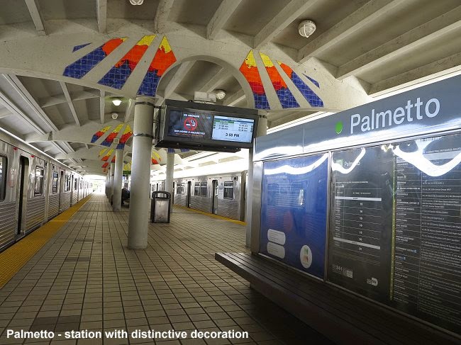
The Metrorail stations are o.k., no exciting architecture or artwork and rather uniform, but generally in a good shape. Like in Atlanta, you need your ticket to get out of the system despite the flat fare system. The only one I remember with a bit of arty decoration is Palmetto, the only station on the first extension of the system:


 The Airport station is quite impressive with its huge vault, the Tri-Rail/Amtrak station next to it still hasn't opened. The weak point here is that everybody has to transfer to the people mover to actually get to the airport. While this is often a good solution when the people mover delivers passengers to different terminals, in Miami the MIA Mover drops everybody at a single station at the airport, and from there you still have to walk a while to get to your terminal. And while at the rail station, exiting and boarding people mover passengers were wisely separated, at the terminal station hords of waiting passengers with luggage obstruct the path for those getting of the train. So, wouldn't it have been wiser to extend Metrorail directly into the airport. Sure, the people mover also serves as a link between the terminal and the rental car station, which is in fact a really huge vestibule, much larger than most train or metro stations in the U.S., and that says a lot about the Americans' travel preferences! So, although the journey from downtown to the Airport is just 15 minutes and thus even shorter than in Atlanta, you need to add at least 10 minutes to walk to and ride the people mover and then walk to the terminal, whereas in Atlanta the rail station is next to the main terminal.


The only major interchange station, that at Government Center where the Metromover runs two levels below Metrorail, is not ideally laid out. There are some escalators missing so they switch the direction according to the main flux of passengers. While this is a logical thing to do, the alternative route is via a hidden lift or rather steep stairs. This interchange was laid out for a second Metrorail line that would cross on the intermediate level. At least part of its platforms plus concrete sleepers are visible on that level, rather ugly and useless anyway, so why don't they use that space for something else? There is no talk about using it for a transit line in the foreseeable future. It really lies there like a ghost station.


I bought a one-day pass for $5.65, but actually paid $7.65 because I purchased an EASY smartcard. Later I found out that like for single tickets you can also get a 1-day pass on a single-use paper smartcard! Anyway, I have started collecting these smartcards now. Otherwise the ticket vending machines were easy to handle and there were plenty of them available. On buses you can still pay cash also.


The downtown Metromover was actually a positive experience, especially after the ridiculous system in Jacksonville. The trains run pretty frequently and are heavily used. Certainly the fact that riding them is free helps to increase ridership. While the Inner Loop line always ran with two cars, the branches vary. I think the southern Brickell loop always had a single car, whereas the northern Omni Loop had one or two cars, without any obvious logic behind that. I think this branch should always have two cars as it does get very busy with people changing to and from buses at the Adrienne Arsht Center stop. But even the southern leg to the Financial Center was well used during late morning hours when you would expect all these office workers to be in their towers. The ride between the junction down that leg is pretty spectacular as the trains climb up steeply to Fifth Street station which lies high above the canal, feels like being on the 6th or 8th floor of a building, and then steep down again. The trains move swiftly, but station dwelling is sometimes a bit too long. It was surprising to see that the new trains have only two seats per car, which says a lot about its popularity, although I think they should add a few more and run double sets instead.


The Metromover stations are proper stations, some high above street level, and unfortunately often only with one escalator, so if this doesn't run in the direction you want, you may have to climb rather steep steps up or down. All stations are equipped with lifts, though. I liked the vaulted roof in some, whose structure reminded me of the Washington DC Metro, though in short, of course.

This morning, however, the Metromover let me down when I wanted to take it to travel towards the airport, as the entire system was closed down, no idea why. So I had to walk across downtown to take Metrorail at Government Center.


In Miami, I was successful in getting a full system map, a Metromover leaflet and a Metrorail timetable! At the Airport they have a staffed office, as well as at Government Center, which is very positive, because this is where one would look for it first. At other stations, there are bus timetables at the entrance, and often with a security guard sitting there, one of them also handed out a full system map they have in cupboards. On the platforms, full system maps and a downtown extract is also displayed, but I didn't see any neighbourhood maps.


Miami-Dade Transit's online trip planner is complete crap. For once, I wanted to prepare a trip properly, knowing that at the busstop it might be difficult to find out where which bus goes, so I did it before on my netbook. I entered two clearly defined addresses to get an answer that no connections were available! Then I clicked on the busstop icon in Google Maps and found out that bus 119 runs frequently from North Beach (where I had to drop my car) to downtown Miami. The Tranist website even showed me a timetable for this line. But when I was out there, the busstops didn't show a bus 119. Instead there was line S going downtown, they must have changed that recently. Anyway, this bus actually runs past my hotel! So why was the system not able to calculate a 1-seat ride? Absolutely useless! Even if it required 3 transfers, the system should be able to provide that information. Unfortunately many transit agencies use only Google Transit, which is a nice service, but too many errors, and if you tell them, they can't change it, because apparently on the transit agencies can make changes. And transit agencies employ lots of incompetent people, unfortunately...

Next stop: San Juan


LINKS


Miami at UrbanRail.Net


Wednesday, 15 October 2014

JACKSONVILLE & TAMPA


JACKSONVILLE Skyway (People Mover)

From Atlanta I flew to Jacksonville on 10 Oct 2014, where I picked up a car to drive through Florida. I really only wanted to stay in Jacksonville for the shortest possible time to see its people mover referred to as 'Skyway'. Luckily, I had planned this stopover for a Friday, so I was actually able to ride it (as I get older I tend to mix up days and although I knew it doesn't operate on weekends, I was happy I made the correct plans...). Anyway, you don't need much time to explore it, trains run frequently every 6-7 minutes, so even a few station stops are possible to take a few photos without spending too much time. The weather was nice and extremely hot, and I got the shots I wanted. And I even didn't have to spend a penny in that city as parking at Convention Center (though not really clear as far as signs go!) and riding the Skyway is free!


Although not shown like this on the maps, the system is operated with a main line, from Rosa Parks Transit Center to Kings Avenue on the south bank, while the spur to the Convention Center was shuttling back and forth from Central during my visit. It seemed that this was normal. The overall impression was that the Skyway is fun but also a bit ridiculous. A 'train' is made of two tiny half-cars, which are not even interconnected, and if it wasn't for the video surveillance system, I would get a bit claustrophobic in them. The trains were fairly busy on a Friday early afternoon, especially between Rosa Parks and Central, people do use it for short hops, but the southbank side was rather quiet, though nicer to take pictures. But I wonder why they gave up the original VAL trains (some of them now run at Chicago O'Hare Airport), which are comparatively well-sized, and replaced them with these ridiculous monorails. Sorry, Bombardier, but not your best delivery! Yet another monorail I consider crap, after that in Las Vegas, Moscow.... The trains are pretty fast, and what I'm often missing on metro systems, the beam has some superelevation in curves, so you can clearly see and feel the train tilt, but in terms of capacity, I would say that a single car of the type running on Miami's Metromover (but with some seats, please) should be the minimum to feel comfortable in them. While the trains on the main line were in their real livery, the shuttle train on the spur was covered with an advert:


The stations are laid out for a least the double length of these trains, and they function without any platform screen doors, although only the section where the doors of the trains are located are open, the rest is protected by a balcony-style railing. Despite being ticketless, there are turnstiles to get in and out, no idea why, maybe to count passengers. I think most stations had escalators and lifts, too.


TAMPA Streetcar (Teco Line Streetcar)

I usually don't care much for heritage streetcars that only run at certain times for the delightment of tourists, but I was positively surprised by the single line in Tampa, Florida. I got there on a Saturday around noon (11 Oct 2014) and was astonished that the terminus in the downtown area had all sorts of information I so often miss with streetcars. There was a map and a full timetable, clearly legible, and a tram every 20 minutes on Saturdays, too. The stations, not just simple stops, are even equipped with ramps for wheelchair access and with a short roof, plus ticket vending machines! Despite being more of a tourist attraction, the TECO Line Streetcar is fully integrated into the city's transport system, so I got a day pass for $5.00 in the form of a magnetic stripcard to hop on and off a few times.


I was also surprised how busy the line got, not so much on the downtown end, but between the Aquarium (Tampa Tribune stop) and the outer end of the line, because that's where all visitors go. There was a market near the terminus, and the stop before that serves a busy leisure area on 7th Street with shops, bars and restaurants. So, I guess there is some traffic even in the evening. And later I found out that all stops have proper timetable information! So many American streetcar operators should come and visit Tampa to see how things should be done. The track and vehicles were in good condition. There is one interesting point where the streetcars have to cross a railway track (also used by Amtrak) perpendicularly at grade. The streetcars first have to make a brake-check stop and then another stop to check signals before actually crossing! Otherwise the single track has several passing loops, so in case of delays, the car in the opposite direction can proceed to the next loop. Unfortunately, all three cars in service that day were covered with adverts on the sides. 


What I was missing, though, was a stop directly in front of the Aquarium, instead you have to get off a few hundred metres before at Tampa Tribune (I assume this is to make people walk along a development called Channelside, or a few hundred metres afterwards, where there is also a car park.

Next stop: Miami


LINKS

Skyway (JTA)


Jacksonville at UrbanRail.Net


Saturday, 11 October 2014

ATLANTA MARTA


After riding only light rail systems and streetcars in the last two weeks, it was nice to finally travel on a real metro once again, after all, my real passion. I arrived on the plane from New Orleans on Oct 7th, so right from the airport to my hotel in downtown I had the chance to use MARTA. In fact, before you actually get to the MARTA station, in most cases you will first enjoy a ride on the underground Plane Train that connects all terminals of this huge airport, somehow in a more logical way than in Dallas-Fort Worth. From the domestic baggage claim it is only a short walk to the MARTA station, and the ticket vending machines seemed easy to handle although they wouldn't take foreign credit cards, i.e. they don't accept foreign ZIP codes, but luckily, there is also at least one staffed ticket counter with a friendly lady helping quickly, so that was a huge plus compared to Chicago O'Hare. I bought a 4-day Breeze card for $20.00, i.e. $19.00 for the 4 days plus $1.00 for the smartcard. The choice of different tickets is also a real plus for MARTA, as you can choose between 1, 2, 3, 4 or 7 days. A single trip would cost $2.50. So, as far as airport connections go, Atlanta can be counted among the best in the U.S., it's a short 20-minute ride to all downtown destinations, and the same train continues further north and also serves Midtown and the Buckhead/Lenox business area, and all for $2.50 or less, and every 5-6 minutes! The Breeze card is needed to get into the station and also to get out, I guess just as a door opener, because with a flat fare system it wouldn't make sense. All gates are for in and out, so be careful before tapping in and make sure noone is coming out the same gate at the same time, as your Breeze pass may then be blocked for a few minutes, if you don't get in immediately where you tapped in. Happened to me once when crowds were coming off a train at North Springs, but describing my problem to an employee, she opened the gate for me. Rail timetables are available at most stations, they include a black-and-white map, no colour maps are available, though, neither full system maps, seem to be out of print, I can only assume that they are waiting for the Streetcar to open before publishing a new edition, otherwise it would be a shame. This brings us directly to MARTA's very bad side, namely bus information. I hardly saw any bus maps posted, and at busstops, except near Five Points or other major interchanges, there is no information at all which bus stops there, where it could take you and when it would happen to pass. So that is a clear fail for MARTA, actually beyond embarrassing! At major rail/bus interchanges there are shelves with plenty of timetables for the lines that depart from there, but honestly, I find these timetables always a bit difficult to read as in the end all you can see for a normal daytime hour is 'buses every 20 minutes' or so. Why is it not possible in so many U.S. cities just to go to a bus stop and see if there is a bus coming and where it is going? Am I really so old-fashioned that I don't want to use a smartphone all the time for these things?

When I left the MARTA system for the first time at Peachtree Center, my first impression of Atlanta was that it is a rather hilly city. Well, Peachtree Center station actually lies deep below the highest point of downtown, so you take very long (and slow as in Western Europe) escalators to reach the surface, but from there you actually walk down in all directions. The second impression was, the street layout is a bit confusing as Atlanta doesn't have a simple and often boring grid system like most U.S. cities. And the third impression was that most streets in Atlanta are called Peachtree, adding to my confusion...

Let's come back to the rail service. The network is pretty simple with basically two routes. Although they introduced line colours in 2009, the signage is still in the original style, with orange for the north-south line and blue for the east-west. I think I even heard a driver once saying 'this is where the West Line ends'. The Gold Line is actually shown in yellow, and if I recall correctly, it was supposed to be called the Yellow Line but apparently the large Chinese community on the northwestern leg objected to this, so they renamed it Gold Line instead.

While the East-West Line seems more like a mere link between downtown (with only two downtown stations, Five Points and Georgia State) and the suburbs, the North-South Line connects many important parts of the city, the airport, the downtown business center, Midtown, which also has lots of offices, the Art Center area, and further north also the Buckhead/Lenox business and shopping area, so it has more of a metro feel to it, although the long station distances in suburban areas also make it an RER/S-Bahn-like rail line, quite like BART.

MARTA uses a logo pole outside stations, with its rainbow colours and the station's name, but on the station building, if there is one, it only says 'marta'. I wonder how locals refer to the rail system? Would they say 'I will take MARTA to the airport' and mean the rail system, as MARTA also operates buses. Or would they just say 'I'll take the train' as there is hardly any other train anyway? Apparently it's not called 'Metro'. But I guess they wouldn't use the line colour either. Inside the stations, there are next-train indicators which usually just say 'Red – North Springs 2 min', depending on the type of screen, this is displayed in the corresponding colour. Generally, these next-train indicators are badly placed. With 183 m long platforms there should be at least three such monitors mounted perpendicularly above the corresponding platfrom edge to be viewed from any point when waiting on the platform, instead they are often placed somewhere in the middle and you actually have to look for them. And again, they often display other things between train announcements, I think this should be strictly separated, you can have all sorts of screens to broadcast adverts or whatever announcements, but the next train should be displayed at all times. Otherwise, directions are given as 'Northbound' etc. When the next train enters the station, you won't miss it, because it blows a full horn twice as it enters the station. Otherwise the trains run rather quietly. Inside the trains, the destination is either announced by a recorded voice or by the driver. On some trains I observed that the 'The next stop is …' message displayed on a rolling indicator remained on even past that station, which can be quite confusing if you don't look up all the time. The train control system should be able to switch to the next station announcement immediately after leaving a station, even though accoustically the announcement may come a few minutes later, given the long distances between some stations. I wonder whether it is really necessary to make announcements like 'Próxima estación' in Spanish, after all, immigrants are still supposed to learn English, I assume, and translating these primitive announcements is a bit like saying, you're too stupid to understand 'the next station is'. Also, I have seen larger hispanic groups in most other U.S. cities. Additional information like 'for elevators get off on the right side' might be more useful to be translated. This information is given at Five Points, where both levels of this immense interchange station have what in Europe used to be referred to as 'Spanish solution' as it had been used in Madrid and Barcelona, i.e. there is an island platform plus two side platforms and train doors open on both sides. Most metro cities would envy Atlanta for this generous interchange station, it actually looks oversized given the number of passengers. I wonder if it ever gets really crowded. 


I also felt a bit lonely at Peachtree Center station, where you would expect a real flux of passengers diving into the station or emerging from it at least at peak hours, instead it may occur that you are the only person on the long escalators, and noone is travelling in the opposite direction either. I was actually surprised this morning just after eight, that two of the three escalators went down, I would have expected to have two upwards to carry large crowds up from the train to their offices...

The trains move quite fast or at least at an acceptable speed between stations. The track, however, seems to be damaged on some sections, so the trains start to jump to an extent that it can become uncomfortable for the passengers, especially between Arts Center and the northern junction. This should be fixed immediately before a derailment occurs, or the ATO system has to be reprogrammed to slow the train down a bit on these sections.

Inside, the trains are very spacious, and despite the hard plastic seats, they were quite comfortable for me. I don't know about real peak hours, but during most of the day, they have almost too much spare capacity, so they could actually shorten the trains to 4 cars instead of 6 (the Green Line runs with only two cars), but probably the splitting process is not worthwhile. Now refurbished, the older trains, which originally had these thick colour bars at the front, now look pretty much like the newer Ansaldo cars, with a black front and just a thin band with the MARTA colours. Some of the married pairs are covered with adverts:


All in all, the system is laid out for much larger crowds, they could operate 8-car trains, and certainly at much shorter intervals. Right now, the headways are not bad, but, of course, on outer sections waiting times between trains can be 12 minutes. All in all, MARTA's rail system reminded me a lot of BART in San Francisco. The trains feel light and swift as they roll over a mix of viaducts, cuttings, freeway medians and tunnels.


The stations along both routes have a similar style, most with rather substantial structures mostly made of concrete, either bare and untreated or with some surface finishing, and given the length of the platforms, the stations really appear big. Most surface stations have uncovered end sections, which is nice when taking a photograph. There are plenty of escalators and also lifts. The floor height of the train exactly matches the platform height, so boarding is easy and fast and station dwelling time is rather short, providing an overall good impression of a swift ride.


The underground stations are not bad, but except for Peachtree Center with its bare rock visible on both side walls, they are not too exciting either, they actually appear a bit dated, and although built in the 1970s, they rather look 1960s, with white tiles in some. Fortunately, like the surface stations, all have some sort of artwork or artistic enhancement to make them a bit more exciting:


They are all pretty spacious, though, but certainly lack the grandeur of Washington DC's Metro. Civic Center has a unique layout being placed on the lower level of a road bridge that spans an urban freeway, with windows on either side. Ashby is noteworthy for having each platform on a different level to allow for the grade-separated junction at its western side. Some stations could be better signposted on street level. At North Avenue, for example, the northern access is hidden inside a building, and there is no real hint to that on the street. I walked past that entrance until I found the southern access which has a street level wegde-shaped entrance building. Even at Peachtree Center, the northern accesses are not too clearly identifiable.

The underground stations can get pretty hot, though, as there is no proper ventilation, instead they have placed huge ventilators on the platforms to alleviate the suffering passengers. This platform temperature is certainly also a result of the hot air disposed by the air-conditioned trains. Stations with side platforms have a feature which is basically good, although not so welcomed by train spotters because it obstructs the view of the train on the opposite track: a band with the station name continuously repeated at the height of the window, so passengers inside the train can easily read where they are. The station information panels have rail system maps, a downtown extract, but unfortunately no neighbourhood map, something nowadays really the standard on state-of-the-art metro systems. So, MARTA, catch up!


I was a bit too early to see the Atlanta Streetcar working. Their website even announced test runs for yesterday, but in the end I didn't see any trams moving when I walked past the depot heading towards the Martin Luther King Jr Historic Site. I'm sure, the tram will help a lot to redevelop this east end area, now a bit run down, but already showing signs of recovery with new construction. The streetcar line seemed pretty finished, all the stops were in place with signs, no electronic displays, though, but high enough platforms to allow level access into the four Siemens S70 cars which have been delivered. But before the line actually starts working, I dare criticise two things which I predict will become an issue soon. The first is not so bad, but I think a central stop should have been placed eastbound before the line crosses Peachtree Street, or just opposite the westbound stop called Woodruff Place. The closest stop to what I would consider the most central point is either further west at Luckie/Cone (the signs actually read 'Luckie at Cone') or further east at Park Place, both out of sight from that intersection, especially the latter one, as it is around the corner. The second issue seems more severe, a programmed delay between the last two stops going west, between Carnegie and Centennial Olympic Park, where on two consecutive days I have observed a severe traffic jam on the lane the streetcar is supposed to share. So, I wonder how they will solve this problem. Otherwise, the streets the tram will roll on, didn't seem too busy, but this will be its vulnerable point. Will they dare to divert traffic to other roads? Let's hope that the initial line is a success and that the streetcar system is extended to other parts of the city, too.

Next stop: JACKSONVILLE


LINKS